Wonosobo Regency
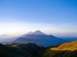
Wonosobo Regency (Javanese: ꦑꦧꦸꦥꦠꦺꦤ꧀ꦮꦤꦱꦧ, romanized: Kabupatèn Wanasaba) is a regency (Indonesian: kabupaten) in Central Java province in Indonesia. Its capital is Wonosobo, located at 7.3684940°S 109.8983841°E, about 120 km from Semarang. The regency is located in Dieng Plateau. Its area is 984.68 km² and its population was 754,883 at the 2010 Census[2] and 879,124 at the 2020 Census.[3]
Wonosobo Regency
ꦑꦧꦸꦥꦠꦺꦤ꧀ꦮꦤꦱꦧ | |
|---|---|
 | |
 Coat of arms | |
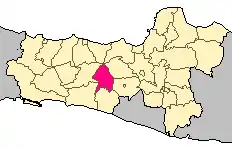 Location within Central Java | |
| Coordinates: 7.2708631°S 109.9140472°E | |
| Country | Indonesia |
| Region | Java |
| Province | Central Java |
| Capital | Wonosobo |
| Government | |
| • Regent | Eko Purnomo |
| • Vice Regent | Agus Subagyo |
| Area | |
| • Total | 984.68 km2 (380.19 sq mi) |
| Population (2020 Census) | |
| • Total | 879,124 |
| • Density | 890/km2 (2,300/sq mi) |
| [1] | |
| Time zone | UTC+7 (IWST) |
| Area code | (+62) 286 |
| Website | wonosobokab |
Etymology
The word "Wonosobo" is derived from Javanese Wanasaba, which in turn came from Sanskrit Vanasabhā. It literally means 'the gathering place in the forest'.
Administrative districts
Wonosobo Regency is divided into the following fifteen districts (kecamatan), tabulated below with their areas and their populations at the 2010 Census[4] and the 2020 Census.[5] The table also includes the number of administrative villages (rural desa and urban kelurahan) in each district and the location of the district headquarters.
| Name | Area in km2 | Pop'n Census 2010 | Pop'n Census 2020 | No. of vill. | Admin centre |
|---|---|---|---|---|---|
| Wadaslintang | 127.16 | 51,402 | 60,502 | 17 | Wadaslintang |
| Kepil | 93.87 | 56,184 | 64,478 | 21 | Kepil |
| Sapuran | 77.72 | 53,845 | 61,209 | 17 | Sapuram |
| Kalibawang | 47.82 | 22,269 | 27,101 | 8 | Karangsambung |
| Kaliwiro | 100.08 | 43,978 | 51,824 | 21 | Kaliwiro |
| Leksono | 44.07 | 39,159 | 46,186 | 14 | Leksono |
| Sukoharjo | 54.29 | 31,228 | 35,459 | 17 | Sukoharjo |
| Selomerto | 39.71 | 44,849 | 53,516 | 24 | Selomerto |
| Kalikajar | 83.30 | 57,476 | 70,302 | 19 | Kalikajar |
| Kertek | 62.14 | 76,386 | 90,207 | 21 | Kertek |
| Wonosobo (town) | 32.38 | 82,488 | 91,909 | 20 | Jaraksari |
| Watumalang | 68.23 | 48,569 | 55,765 | 16 | Wonoroto |
| Mojotengah | 45.07 | 58,163 | 67,481 | 19 | Kalibeber |
| Garung | 51.22 | 47,954 | 56,988 | 15 | Garung |
| Kejajar | 57.62 | 40,933 | 46,197 | 16 | Kejajar |
| Totals | 984.68 | 754,883 | 879,124 | 265 |
Climate
Wonosobo has an elevation moderated tropical rainforest climate (Af) with moderate rainfall from July to September and heavy to very heavy rainfall in the remaining months. The following climate data is for the town of Wonosobo.
| Climate data for Wonosobo | |||||||||||||
|---|---|---|---|---|---|---|---|---|---|---|---|---|---|
| Month | Jan | Feb | Mar | Apr | May | Jun | Jul | Aug | Sep | Oct | Nov | Dec | Year |
| Average high °C (°F) | 26.0 (78.8) |
26.2 (79.2) |
26.6 (79.9) |
26.8 (80.2) |
27.1 (80.8) |
27.1 (80.8) |
26.9 (80.4) |
27.3 (81.1) |
27.5 (81.5) |
27.7 (81.9) |
26.8 (80.2) |
26.0 (78.8) |
26.8 (80.3) |
| Daily mean °C (°F) | 22.0 (71.6) |
22.1 (71.8) |
22.4 (72.3) |
22.5 (72.5) |
22.8 (73.0) |
22.3 (72.1) |
21.8 (71.2) |
22.0 (71.6) |
22.4 (72.3) |
22.9 (73.2) |
22.4 (72.3) |
21.8 (71.2) |
22.3 (72.1) |
| Average low °C (°F) | 18.0 (64.4) |
18.0 (64.4) |
18.2 (64.8) |
18.3 (64.9) |
18.5 (65.3) |
17.5 (63.5) |
16.7 (62.1) |
16.7 (62.1) |
17.3 (63.1) |
18.1 (64.6) |
18.1 (64.6) |
17.7 (63.9) |
17.8 (64.0) |
| Average rainfall mm (inches) | 513 (20.2) |
443 (17.4) |
486 (19.1) |
339 (13.3) |
254 (10.0) |
136 (5.4) |
110 (4.3) |
93 (3.7) |
118 (4.6) |
237 (9.3) |
357 (14.1) |
486 (19.1) |
3,572 (140.5) |
| Source: Climate-Data.org[6] | |||||||||||||
References
- Badan Pusat Statistik, Jakarta, 2021.
- Biro Pusat Statistik, Jakarta, 2011.
- Badan Pusat Statistik, Jakarta, 2021.
- Biro Pusat Statistik, Jakarta, 2011.
- Badan Pusat Statistik, Jakarta, 2021.
- "Climate: Wonosobo". Climate-Data.org. Retrieved 12 November 2020.
External links
| Wikimedia Commons has media related to Wonosobo Regency. |
| Wikivoyage has a travel guide for Wonosobo. |
Regencies and cities of Central Java | ||
|---|---|---|
Capital: Semarang | ||
| Regencies |  | |
| Cities | ||