Vorsklytsia
Vorsklytsia (Ukrainian: Ворсклиця) is a river in the Belgorod Oblast of Russia and the Sumy Oblast of Ukraine and a right tributary of the Vorskla.
| Vorsklytsia | |
|---|---|
 | |
| Native name | Ворсклиця (Ukrainian) |
| Location | |
| Country | Russia, Ukraine |
| Region | Belgorod Oblast, Sumy Oblast |
| Physical characteristics | |
| Source | |
| • location | Central Russian Upland near Proletarsky |
| • coordinates | 50°46′26″N 35°46′52″E |
| Mouth | Vorskla |
• coordinates | 50°22′39″N 35°06′54″E |
| Length | 101 km (63 mi)[1] |
| Basin size | 1,480 km2 (570 sq mi)[1] |
| Basin features | |
| Progression | Dnieper→ Dnieper–Bug estuary→ Black Sea |
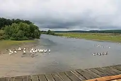
The valley of Vorsklytsia is trapezoidal with a width of 4–5 km (2.5–3.1 mi) and the river runs in great meanders. The floodplains are swampy, especially in the lower reaches, the right bank is often quite steep, the left bank rather low. The gradient of Vorsklytsia is 0.77 m/km. The river freezes in early December and remains frozen until mid-March.[1][2]
References
- Географічна енциклопедія України : у 3 т. / редколегія: О. М. Маринич (відпов. ред.) та ін. — К. : «Українська радянська енциклопедія» ім. М. П. Бажана, 1989
- Worsklica // Słownik geograficzny Królestwa Polskiego i innych krajów słowiańskich. — Warszawa : Filip Sulimierski i Władysław Walewski, 1895. — T. XIV : Worowo — Żyżyn.
This article is issued from Wikipedia. The text is licensed under Creative Commons - Attribution - Sharealike. Additional terms may apply for the media files.