Visakhapatnam district
Visakhapatnam district (formerly known as Vizagapatam district[4]) is one of the nine districts in the Coastal Andhra region of the Indian state of Andhra Pradesh, headquartered at Visakhapatnam.[5]: 14 It is one of the nine coastal districts of the state.The district share broders with in the north and east, Vizianagaram district , Anakapalle district in the south-west and Bay of Bengal in the south.[5]: 15
Visakhapatnam district | |
|---|---|
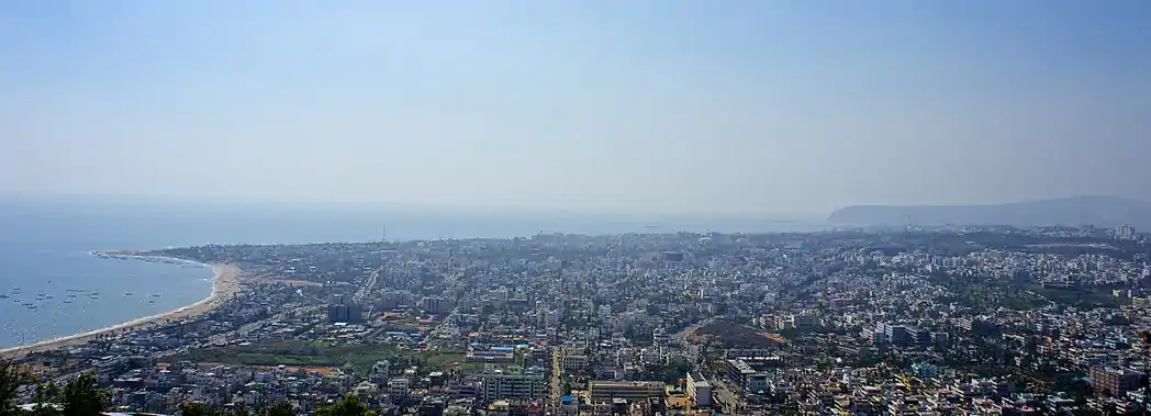  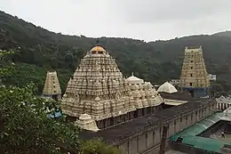 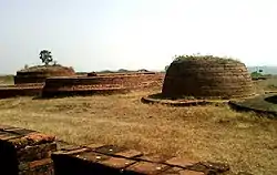 Clockwise from top: View of Visakhapatnam from Kailasagiri, Simhachalam Temple, Stupas at Bavikonda, pylon at Visakhapatnam Steel Plant | |
| Nickname(s): Vizag | |
.svg.png.webp) Location of Visakhapatnam district in Andhra Pradesh | |
| Coordinates: 17.7°N 83.3°E | |
| Country | |
| State | Andhra Pradesh |
| Created | 1 April 1936 |
| Headquarters | Visakhapatnam |
| Administrative Divisions | |
| Government | |
| • District collector | Dr A Mallikharjuna IAS |
| Area [1]: 28 | |
| • Total | 1,048 km2 (405 sq mi) |
| • Urban [1]: 28 | 632.16 km2 (244.08 sq mi) |
| • Rural [1]: 28 | 416 km2 (161 sq mi) |
| • Rank | 26th |
| Population (2011)[2] | |
| • Total | 1,959,544 |
| • Rank | 13th |
| • Density | 1,869.8/km2 (4,843/sq mi) |
| • Rank | 8th |
| • Sex ratio | 1,006♀️/1,000♂️ |
| Languages | |
| • Official | Telugu |
| Literacy | |
| Time zone | UTC+5:30 (IST) |
| Postal Index Number | 530xxx |
| Area codes | +91–891 |
| ISO 3166 code | IN-AP |
| Vehicle registration | AP-31, AP–39 (from 30 January 2019)[3] |
| Website | visakhapatnam |
History
During the British rule in India, Visakhapatnam emerged as a district. On 1 April 1936, Bihar and Orissa Province was split to form Bihar Province and Orissa Province. Parts of the Vizagapatam district (i.e., Nabarangpur, Malkangiri, Koraput, Jeypore, Rayagada etc.) and the Ganjam district (excluding Ichchapuram, Palasa, Tekkali, Pathapatnam and Srikakulam) of Madras Presidency were transferred to Orissa Province along with portions of the Vizagapatam Hill Tracts Agency and Ganjam Hill Tracts Agency.[6][7][8]
Later, in 1950, Srikakulam district was carved out from the erstwhile Visakhapatnam district.[9] In 1979, part of the district was split to form Vizianagaram district.[10] Visakhapatnam district is currently a part of the Red corridor.[11]
Administratve divisions
The district has two revenue divisions, namely Bheemunipatnam and Visakhapatnam, each headed by a sub collector. These revenue divisions are divided into 11 mandals. The district consists of one municipal corporation. Visakhapatnam city is the only municipal corporation.[12]
Mandals
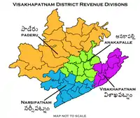
There are 6 mandals in Visakhapatnam division and 5 in Bheemunipatnam division. The 11 mandals under their revenue divisions are listed below:
| # | Bheemunipatnam Division | Visakhapatnam Division |
|---|---|---|
| 1 | Bheemunipatnam | Gajuwaka |
| 2 | Anandapuram | Pedagantyada |
| 3 | Padmanabham | Gopalapatnam |
| 4 | Visakhapatnam Rural | Mulagada |
| 5 | Seethammadhara | Maharanipeta |
| 6 | Pendurthi |
Politics
There are two parliamentary and six assembly constituencies in Visakhapatnam district. The parliamentary constituencies are
- Visakhapatnam
- Anakapalli (partially)
The assembly constituencies are[13]
Demographics
| Year | Pop. | ±% p.a. |
|---|---|---|
| 1901 | 992,833 | — |
| 1911 | 1,056,683 | +0.63% |
| 1921 | 1,057,223 | +0.01% |
| 1931 | 1,175,984 | +1.07% |
| 1941 | 1,314,362 | +1.12% |
| 1951 | 1,483,653 | +1.22% |
| 1961 | 1,665,213 | +1.16% |
| 1971 | 2,035,831 | +2.03% |
| 1981 | 2,576,474 | +2.38% |
| 1991 | 3,285,092 | +2.46% |
| 2001 | 3,832,336 | +1.55% |
| 2011 | 4,290,589 | +1.14% |
| source:[14] | ||
According to the 2011 census Visakhapatnam district has a population of 4,290,589. This gives it a ranking of 44 in India (out of a total of 640 districts) and 4th in the state. The district has a population density of 384 inhabitants per square kilometre (990/sq mi). Its population growth rate over the decade 2001–2011 was 11.89%. It has a sex ratio of 1003 females for every 1000 males, and a literacy rate of 67.7%. After reorganization, Visakhapatnam district had a population of 1,959,544. Scheduled Castes and Scheduled Tribes made up 167,272 (8.54%) and 22,574 (1.15%) of the population respectively.[5]
Hindus are the predominant community in the district. Muslims and Christians are primarily in the Visakhapatnam metropolitan area.
At the time of the 2011 census, 92.93% of the population spoke Telugu, 2.47% Urdu, and 1.96% Hindi as their first language.[16]
| Total population | 42,90,589 |
| Males | 21,38,910 |
| Females | 21,51,679 |
| Growth (2001-2011) | 11.89% |
| Rural | 22,54,667 (52.55%) |
| Urban | 20,35,922 (47.45%) |
| SC | 1,67,272 (7.68%) |
| ST | 22,574 (14.42%) |
Geography
Visakhapatnam district occupies an area of approximately 11,161 square kilometres (4,309 sq mi),[17] comparatively equivalent to Canada's Cape Breton Island.[18]
Climate
| Climate data for Visakhapatnam | |||||||||||||
|---|---|---|---|---|---|---|---|---|---|---|---|---|---|
| Month | Jan | Feb | Mar | Apr | May | Jun | Jul | Aug | Sep | Oct | Nov | Dec | Year |
| Average high °C (°F) | 28.9 (84.0) |
31.3 (88.3) |
33.8 (92.8) |
35.3 (95.5) |
36.2 (97.2) |
35.3 (95.5) |
32.9 (91.2) |
32.7 (90.9) |
32.5 (90.5) |
31.7 (89.1) |
30.4 (86.7) |
28.9 (84.0) |
32.5 (90.5) |
| Average low °C (°F) | 18.0 (64.4) |
19.9 (67.8) |
23.0 (73.4) |
26.1 (79.0) |
27.7 (81.9) |
27.3 (81.1) |
26.1 (79.0) |
26.0 (78.8) |
25.6 (78.1) |
24.3 (75.7) |
21.6 (70.9) |
18.6 (65.5) |
23.7 (74.7) |
| Average precipitation mm (inches) | 11.4 (0.45) |
7.7 (0.30) |
7.5 (0.30) |
27.6 (1.09) |
57.8 (2.28) |
105.6 (4.16) |
134.6 (5.30) |
141.2 (5.56) |
174.8 (6.88) |
204.3 (8.04) |
65.3 (2.57) |
7.9 (0.31) |
945.7 (37.23) |
Economy
The Gross District Domestic Product (GDDP) of the district is ₹73,276 crore (US$9.6 billion) and it contributes 14% to the Gross State Domestic Product (GSDP). For the FY 2013–14, the per capita income at current prices was ₹124,162 (US$1,600). The primary, secondary and tertiary sectors of the district contribute ₹6,300 crore (US$830 million), ₹21,654 crore (US$2.8 billion) and ₹45,321 crore (US$5.9 billion) respectively.[19] The major products contributing to the GVA of the district from agriculture and allied services are, sugarcane, paddy, betel leaves, mango, milk, meat and fisheries. The GVA to the industrial and service sector is contributed from manufacturing, construction, minor minerals, software services and unorganised trade.[19]
Transport
The total road length of state highways in the district is 964 km (599 mi).[20]
Education
The primary and secondary school education is imparted by government, aided and private schools, under the School Education Department of the state.[21][22] They include 162 government, 2,793 mandal and zilla parishads, 9 residential, 1225 private, 5 model, 34 Kasturba Gandhi Balika Vidyalaya (KGBV), 147 municipal and 829 other types of schools.[23] The total number of students enrolled in primary, upper primary and high schools of the district are 609,587.[24]
Temples
There are thirty six temples under the management of Endowments Department.[25]
References
- "District Census Hand Book – Visakhapatnam" (PDF). Census of India. Registrar General and Census Commissioner of India. Retrieved 14 June 2019.
- "Population". Census of India. Registrar General and Census Commissioner of India. Retrieved 14 June 2019.
- "New 'AP 39' code to register vehicles in Andhra Pradesh launched". The New Indian Express. Vijayawada. 31 January 2019. Retrieved 9 June 2019.
- Pradhāna, Rāmacandra (2008). Raj to Swaraj: A Textbook on Colonialism and Nationalism in India. Macmillan India. ISBN 978-0-230-63406-0.
- "District Census Hand Book : Visakhapatnam (Part A)" (PDF). Census of India. Directorate of Census Operations, Andhra Pradesh. 2011. Retrieved 1 June 2019.
- Provinces of British India
- "The Untouchables". Siddharth Books & Google ebooks. 1948. Retrieved 2 April 2022.
- April 1,1936: Odisha comes into being. Knappilly. 1 April 2018. ISBN 9788190568920. Retrieved 2 April 2022.
- "AP new districts: First formed under the empire, Andhra Pradesh's map shaped and reshaped over centuries". The Times of India. 30 March 2022. Retrieved 2 April 2022.
{{cite web}}: CS1 maint: url-status (link) - Law, Gwillim (25 September 2011). "Districts of India". Statoids. Retrieved 11 October 2011.
- "83 districts under the Security Related Expenditure Scheme". IntelliBriefs. 11 December 2009. Retrieved 17 September 2011.
- "Adminsistrative divisions of Visakhapatnam district". Official Website of Visakhapatnam District. National Informatics Centre. Retrieved 16 January 2015.
- "District-wise Assembly-Constituencies". ceoandhra.nic.in.
- Decadal Variation In Population Since 1901
- "Population by Religion - Andhra Pradesh". censusindia.gov.in. Office of the Registrar General & Census Commissioner, India. 2011.
- "Census of India Website : Office of the Registrar General & Census Commissioner, India". www.censusindia.gov.in.
- Srivastava, Dayawanti et al. (ed.) (2010). "States and Union Territories: Andhra Pradesh: Government". India 2010: A Reference Annual (54th ed.). New Delhi, India: Additional Director General, Publications Division, Ministry of Information and Broadcasting (India), Government of India. pp. 1111–1112. ISBN 978-81-230-1617-7.
{{cite book}}:|last1=has generic name (help) - "Island Directory Tables: Islands by Land Area". United Nations Environment Program. 18 February 1998. Retrieved 11 October 2011.
Cape Breton Island 10,311km2
- "Economy of Visakhapatnam District". Andhra Pradesh Economic Development Board. Retrieved 25 April 2017.
- "Existing State Highways" (PDF). Andhra Pradesh Road Development Corporation. Government of Andhra Pradesh. p. 1. Archived from the original (PDF) on 20 September 2018. Retrieved 11 May 2019.
- "School Education Department" (PDF). School Education Department, Government of Andhra Pradesh. Archived from the original (PDF) on 19 March 2016. Retrieved 7 November 2016.
- "The Department of School Education – Official AP State Government Portal". www.ap.gov.in. Archived from the original on 7 November 2016. Retrieved 7 November 2016.
- "School Information Report". Commissionerate of School Education. Government of Andhra Pradesh. Archived from the original on 8 November 2016. Retrieved 8 November 2016.
- "Student Information Report". Commissionerate of School Education. Child info 2015–16, District School Education – Andhra Pradesh. Archived from the original on 22 May 2015. Retrieved 8 November 2016.
- "Trust Boards Abstract". AP Temples Portal, Government of Andhra Pradesh. Retrieved 24 July 2018.
External links
| Wikimedia Commons has media related to Visakhapatnam district. |
- Official Website
- Vizagport
- Chisholm, Hugh, ed. (1911). . Encyclopædia Britannica. Vol. 28 (11th ed.). Cambridge University Press. pp. 164–165. This contains a detailed description of the town and district under British rule.
Places adjacent to Visakhapatnam district | |
|---|---|
| Topics | |||
|---|---|---|---|
| Regions | |||
| Districts | |||
| Million-plus cities | |||
| Cities (population over 1 lakh) |
| ||
| Tourism |
| ||
| History | |||
| Related lists | |||
| |||