Villers-au-Bois
Villers-au-Bois (French pronunciation: [vilɛʁ o bwa]) is a commune in the Pas-de-Calais department in the Hauts-de-France region of France.
Villers-au-Bois | |
|---|---|
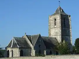 The church of Villers-au-Bois | |
Location of Villers-au-Bois 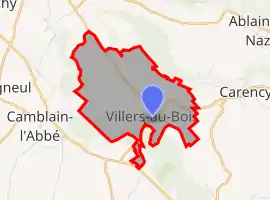 | |
 Villers-au-Bois  Villers-au-Bois | |
| Coordinates: 50°22′26″N 2°40′20″E | |
| Country | France |
| Region | Hauts-de-France |
| Department | Pas-de-Calais |
| Arrondissement | Lens |
| Canton | Bully-les-Mines |
| Intercommunality | CA Lens-Liévin |
| Government | |
| • Mayor (2020–2026) | Bernadette Doutremepuich[1] |
| Area 1 | 5.2 km2 (2.0 sq mi) |
| Population | 599 |
| • Density | 120/km2 (300/sq mi) |
| Time zone | UTC+01:00 (CET) |
| • Summer (DST) | UTC+02:00 (CEST) |
| INSEE/Postal code | 62854 /62144 |
| Elevation | 99–162 m (325–531 ft) (avg. 146 m or 479 ft) |
| 1 French Land Register data, which excludes lakes, ponds, glaciers > 1 km2 (0.386 sq mi or 247 acres) and river estuaries. | |
Geography
Villers-au-bois is surrounded by woodland and situated some 8 miles (12.9 km) northwest of Arras, at the junction of the D65 and D58 roads.
Population
| Year | Pop. | ±% p.a. |
|---|---|---|
| 1968 | 298 | — |
| 1975 | 311 | +0.61% |
| 1982 | 335 | +1.07% |
| 1990 | 369 | +1.22% |
| 1999 | 379 | +0.30% |
| 2007 | 437 | +1.80% |
| 2012 | 563 | +5.20% |
| 2017 | 568 | +0.18% |
| Source: INSEE[3] | ||
Places of interest
- The church, dating from the sixteenth century.
- The large Commonwealth War Graves Commission cemetery: Villers Station Cemetery
References
- "Répertoire national des élus: les maires". data.gouv.fr, Plateforme ouverte des données publiques françaises (in French). 9 August 2021.
- "Populations légales 2019". The National Institute of Statistics and Economic Studies. 29 December 2021.
- Population en historique depuis 1968, INSEE
This article is issued from Wikipedia. The text is licensed under Creative Commons - Attribution - Sharealike. Additional terms may apply for the media files.