Val-de-Reuil
Val-de-Reuil (French pronunciation: [val də ʁœj]) is a commune in the Eure department in Normandy in north-western France. It is located south of Rouen in a loop of the Seine. Created as the new town of Le Vaudreuil in 1972, its name was changed to Val-de-Reuil in 1984 to avoid confusion with its neighbour, Le Vaudreuil.
Val-de-Reuil | |
|---|---|
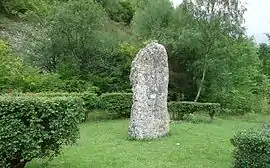 The menhir of La Basse Crémonville | |
.svg.png.webp) Coat of arms | |
Location of Val-de-Reuil 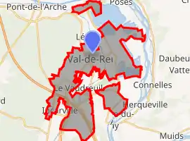 | |
 Val-de-Reuil 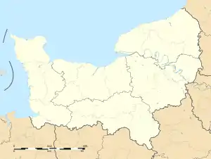 Val-de-Reuil | |
| Coordinates: 49°17′N 1°13′E | |
| Country | France |
| Region | Normandy |
| Department | Eure |
| Arrondissement | Les Andelys |
| Canton | Val-de-Reuil |
| Intercommunality | CA Seine-Eure |
| Government | |
| • Mayor (2020–2026) | Marc-Antoine Jamet[1] |
| Area 1 | 26.61 km2 (10.27 sq mi) |
| Population | 12,910 |
| • Density | 490/km2 (1,300/sq mi) |
| Time zone | UTC+01:00 (CET) |
| • Summer (DST) | UTC+02:00 (CEST) |
| INSEE/Postal code | 27701 /27100 |
| Elevation | 4–120 m (13–394 ft) (avg. 13 m or 43 ft) |
| 1 French Land Register data, which excludes lakes, ponds, glaciers > 1 km2 (0.386 sq mi or 247 acres) and river estuaries. | |
International relations
Val-de-Reuil is twinned with Workington in the United Kingdom.
Population
The inhabitants of Val-de-Reuil are called Rolivalois.
| Year | Pop. | ±% |
|---|---|---|
| 1968 | 398 | — |
| 1975 | 378 | −5.0% |
| 1982 | 4,400 | +1064.0% |
| 1990 | 11,359 | +158.2% |
| 1999 | 13,245 | +16.6% |
| 2008 | 13,702 | +3.5% |
History
Le Vaudreuil (ensemble urbain) was one of the nine new towns created in France in the beginning of the 1970s.
- June 1972: creation of the Établissement public d'aménagement of the new town of Le Vaudreuil.
- December 1972: creation of the urban community (ensemble urbain) of Le Vaudreuil on the territory of several existing communes including Le Vaudreuil.
- 28 September 1981: the urban community became a commune, created from parts of the communes Incarville, Léry, Porte-Joie, Poses, Saint-Étienne-du-Vauvray, Saint-Pierre-du-Vauvray, Tournedos-sur-Seine and Le Vaudreuil. The new commune was named Le Vaudreuil-Ex Ensemble Urbain.[3]
- 19 November 1984: the commune changed its name to Val-de-Reuil to avoid confusion with nearby Le Vaudreuil.[3]
- December, 1985: the dissolution of the établissement public d'aménagement, whose competences were transferred into the commune.
- 1996: Val-de-Reuil joined a communauté de communes with Louviers and Incarville.
- 2001: Val-de-Reuil became part of the Communauté d'agglomération Seine-Eure which has its principal centre in Louviers.
Administration
Val-de-Reuil is the seat of a canton, which includes eight communes and has a total population of 20,555 (1999).
See also
References
- "Répertoire national des élus: les maires". data.gouv.fr, Plateforme ouverte des données publiques françaises (in French). 2 December 2020.
- "Populations légales 2019". The National Institute of Statistics and Economic Studies. 29 December 2021.
- INSEE fiche Val-de-Reuil
External links
| Wikimedia Commons has media related to Val-de-Reuil. |
This article is issued from Wikipedia. The text is licensed under Creative Commons - Attribution - Sharealike. Additional terms may apply for the media files.