U.S. Route 23 in Kentucky
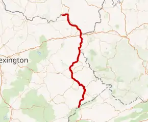
U.S. Route 23 (US 23) is a 157.765-mile-long (253.898 km) United States Numbered Highway in the state of Kentucky. It travels from the Virginia commonwealth line near Jenkins to the Ohio state line west of South Shore via Jenkins, Pikeville, Coal Run Village, Prestonsburg, Paintsville, Louisa, Catlettsburg, Ashland, Russell, Flatwoods, Raceland, Wurtland, Greenup, and South Shore.
 | ||||
|---|---|---|---|---|
| Country Music Highway | ||||
 US 23 highlighted in red | ||||
| Route information | ||||
| Maintained by KYTC | ||||
| Length | 157.765 mi[1] (253.898 km) | |||
| Major junctions | ||||
| South end | ||||
| ||||
| North end | ||||
| Location | ||||
| Country | United States | |||
| State | Kentucky | |||
| Counties | Letcher, Pike, Floyd, Johnson, Lawrence, Boyd, Greenup | |||
| Highway system | ||||
| ||||
| ||||
Route description
US 23 enters Kentucky at the Virginia state line southeast of Jenkins. After a little over a mile, it intersects US 119 at a partial interchange on the Jenkins city line, and US 119 runs concurrently with US 23. The highway then head in a northeasterly direction, bypassing Jenkins. The two then meet US 460 at another partial interchange along the Levisa Fork in extreme southern Pikeville, and US 460 also joins the concurrency. The highway bypasses Pikeville along the Pikeville Cut-Through before US 119 splits off to the east. US 23/US 460 begins running northeast through Coal Run Village and around both Prestonsburg and Paintsville, where US 460 splits off to the west northwest of Paintsville. US 23 then begins running northeastward, before easing into a northerly direction, bypassing Louisa, after which it begins paralleling the Big Sandy River. The route intersects Interstate 64 (I-64) next to the Catlettsburg Refinery before entering the town of Catlettsburg, where it begins a concurrency with US 60. The highway continues north before curving to the northwest to enter Ashland, where US 60 splits off. After Ashland, US 23 continues to run northwestward, paralleling the Ohio River, and running through or around the towns of Russell, Flatwoods, Raceland, Wurtland, and Greenup. After Greenup, it switches to a more northward direction in parallel with the Ohio River before making a sharp change to the west, after which it enters South Shore. Just west of South Shore, US 23 meets the eastern terminus of the eastern segment of Kentucky Route 8 (HY 8), where it turns north and crosses into Portsmouth, Ohio, via the U.S. Grant Bridge across the Ohio River.
Major intersections
| County | Location | mi[1] | km | Exit | Destinations | Notes |
|---|---|---|---|---|---|---|
| Pound Gap | 0.000 | 0.000 | Continuation into Virginia | |||
| Kentucky–Virginia line | ||||||
| Letcher | Jenkins | 1.142– 1.285 | 1.838– 2.068 | Partial interchange; southern end of US 119 concurrency | ||
| 1.500 | 2.414 | Western terminus of KY 3086 | ||||
| 2.460 | 3.959 | Interchange via connector road and northbound entrance ramp | ||||
| Pike | | 10.663 | 17.160 | Southern terminus of KY 3527 | ||
| Dorton | 11.655 | 18.757 | Eastern terminus of KY 805 | |||
| | 15.291 | 24.608 | Northern terminus of KY 611 | |||
| | 19.111 | 30.756 | Eastern terminus of KY 1469 | |||
| | 21.187 | 34.097 | Northern terminus of KY 2167 | |||
| | 22.503 | 36.215 | 15 | Interchange; western terminus of KY 3174; Future rerouting of US 460 east; Corridor Q | ||
| Pikeville | 26.104– 26.374 | 42.010– 42.445 | Interchange; southern end of US 460/KY 80 concurrency | |||
| 30.260 | 48.699 | Southern end of KY 1426 concurrency | ||||
| 30.382 | 48.895 | At-grade intersection; south end of freeway; southern terminus of KY 3496 | ||||
| 30.897 | 49.724 | 23 | Interchange; northern end of KY 1426 concurrency | |||
| 31.665 | 50.960 | 24 | North end of freeway | |||
| 32.144 | 51.731 | Partial interchange includes northbound entrance ramp | ||||
| 32.928 | 52.992 | Northern terminus of KY 3495 | ||||
| 33.610 | 54.090 | Northern end of US 119 concurrency | ||||
| | 34.697 | 55.839 | Western terminus of KY 3227 | |||
| | 36.783 | 59.197 | Southern terminus of KY 2061 | |||
| | 38.922 | 62.639 | Western terminus of KY 3218 | |||
| | 40.125 | 64.575 | Western terminus of KY 1384 | |||
| Floyd | Harold | 41.016 | 66.009 | Eastern terminus of KY 680 | ||
| | 42.570 | 68.510 | Eastern terminus of KY 2557 | |||
| Banner | 49.105 | 79.027 | Western terminus of KY 1426 | |||
| Allen | 50.685 | 81.570 | ||||
| Watergap | 52.922 | 85.170 | Interchange; northern end of KY 80 concurrency; southern terminus of KY 302 | |||
| | 53.632 | 86.312 | Southern terminus of KY 3384 | |||
| Prestonsburg | 55.847 | 89.877 | Interchange; future eastern terminus of Mountain Parkway | |||
| | 57.636 | 92.756 | Eastern terminus of KY 1427 | |||
| | 57.952 | 93.265 | Northern terminus of KY 1428 | |||
| | 60.218 | 96.911 | ||||
| | 60.592 | 97.513 | Southern terminus of KY 3 | |||
| Johnson | | 62.269 | 100.212 | Northern terminus of KY 1100 | ||
| Paintsville | 64.119 | 103.190 | Northern terminus of KY 1750 | |||
| 64.540 | 103.867 | Southern terminus of KY 1428 | ||||
| 66.169 | 106.489 | Partial interchange includes northbound entrance ramp | ||||
| 68.858 | 110.816 | Interchange; northern end of US 460 concurrency; northbound exit and southbound entrance | ||||
| 69.075 | 111.165 | Interchange; southbound exit and northbound entrance | ||||
| | 70.099 | 112.813 | Northern terminus of KY 321 | |||
| | 71.117 | 114.452 | Southern terminus of KY 201 | |||
| Nippa | 73.326 | 118.007 | Eastern terminus of KY 1559 | |||
| | 73.789 | 118.752 | Northern terminus of KY 993 | |||
| | 78.269 | 125.962 | Northern terminus of KY 3224 | |||
| Lawrence | | 83.908 | 135.037 | Western terminus of KY 645 | ||
| | 84.989 | 136.777 | Southern terminus of KY 1760 | |||
| | 85.508 | 137.612 | Northern terminus of KY 581 | |||
| | 89.740 | 144.423 | Western terminus of KY 2038 | |||
| | 93.657 | 150.726 | Southern terminus of KY 2565 | |||
| | 93.933 | 151.171 | Eastern terminus of KY 3395 | |||
| | 95.965 | 154.441 | Northern terminus of KY 32 Connector | |||
| | 97.407 | 156.761 | ||||
| | 100.627 | 161.943 | Eastern terminus of KY 3398 | |||
| | 107.534 | 173.059 | Northern terminus of KY 707 | |||
| Boyd | | 110.987 | 178.616 | |||
| | 114.098 | 183.623 | ||||
| | 115.043 | 185.144 | Western terminus of KY 2842 | |||
| | 118.521 | 190.741 | Northern terminus of KY 3 | |||
| | 118.593– 118.733 | 190.857– 191.082 | I-64 exit 191 | |||
| | 119.009 | 191.526 | Eastern terminus of KY 538 | |||
| Catlettsburg | 120.393 | 193.754 | ||||
| 120.473 | 193.882 | Southern end of US 60 concurrency | ||||
| 121.533 | 195.588 | Western terminus of KY 2535 | ||||
| 121.653 | 195.782 | Southern terminus of KY 168 | ||||
| 122.206 | 196.671 | Eastern terminus of KY 3294 | ||||
| Ashland | 125.019 | 201.199 | Southern terminus of US 23 Bus.; northbound outbound access and southbound inbound access only | |||
| 126.8 | 204.1 | One-way street, inbound access only from US 60 | ||||
| 126.863 | 204.166 | One-way street, outbound access only to US 60 east; northern end of US 60 concurrency | ||||
| 127.050 | 204.467 | Northern terminus of US 23 Bus.; southbound outbound access and northbound inbound access only | ||||
| West Mall Entrance | Interchange; to Ashland Town Center; northbound exit only | |||||
| 128.411 | 206.657 | Northern terminus of KY 168 | ||||
| Westwood | 128.806 | 207.293 | Northern terminus of KY 5 | |||
| Greenup | Russell | 129.299 | 208.087 | Eastern terminus of KY 693 | ||
| 130.224 | 209.575 | Northern terminus of KY 1725 | ||||
| 131.020 | 210.856 | Eastern terminus of KY 224; southern terminus of the Oakley C. Collins Bridge (Ironton-Russell Bridge) | ||||
| 131.069 | 210.935 | Eastern terminus of KY 750 | ||||
| 131.652 | 211.873 | Western terminus of KY 2543 | ||||
| Flatwoods | 132.143 | 212.664 | Northern terminus of KY 207 | |||
| Raceland | 133.295 | 214.518 | Eastern terminus of KY 3105 | |||
| 133.509 | 214.862 | |||||
| | 135.558 | 218.159 | ||||
| Wurtland | 136.581 | 219.806 | ||||
| 136.950 | 220.400 | |||||
| 137.061 | 220.578 | Western terminus of KY 3105 | ||||
| Greenup | 138.638 | 223.116 | Southern terminus of KY 410 | |||
| 139.253 | 224.106 | Northern terminus of KY 1; southern terminus of KY 2541 | ||||
| 140.179 | 225.596 | |||||
| 140.738 | 226.496 | Northern terminus of KY 2541 | ||||
| | 140.898 | 226.753 | Northern terminus of KY 3307 | |||
| | 141.609 | 227.898 | Eastern terminus of KY 827 | |||
| Lloyd | 143.050 | 230.217 | Southern terminus of KY 3116 | |||
| | 145.510 | 234.176 | Access road to the Jesse Stuart Memorial Bridge | |||
| | 146.524 | 235.808 | Northern terminus of KY 3116 | |||
| | 148.011 | 238.201 | Southern terminus of KY 1043 | |||
| | 152.544 | 245.496 | Eastern terminus of KY 3117 | |||
| | 153.038 | 246.291 | Southern terminus of KY 2542 | |||
| | 153.448 | 246.951 | Western terminus of KY 3117 | |||
| | 153.864 | 247.620 | Northern terminus of KY 1043 | |||
| South Shore | 155.726 | 250.617 | Eastern terminus of KY 1082 | |||
| 155.942 | 250.964 | |||||
| | 157.765 | 253.898 | Southern terminus of US 23 Truck; eastern terminus of KY 8; southern terminus of the U.S. Grant Bridge | |||
| Ohio River | U.S. Grant Bridge Kentucky–Ohio line | |||||
| Continuation into Ohio | ||||||
1.000 mi = 1.609 km; 1.000 km = 0.621 mi
| ||||||
See also
 U.S. roads portal
- Special routes of U.S. Route 23
References
- "Official DMI Route Log". Kentucky Transportation Cabinet. Retrieved June 18, 2017.