Tut, Turkey
Tut is a rural district of Adıyaman Province of Turkey, to the north-west of the city of Adıyaman in the range of the Taurus Mountains called the Haci Muhammed. The mayor is Mehmet Kılıc for the Republican People's Party (CHP).[3] The Kaymakam is Yunus Kızılgüneş.[4]
Tut | |
|---|---|
 Tut | |
| Coordinates: 37°47′48″N 37°54′54″E | |
| Country | Turkey |
| Province | Adıyaman |
| Government | |
| • Mayor | Mehmet Kılıç (CHP) |
| • Kaymakam | Yunus Kızılgüneş |
| Area | |
| • District | 486.59 km2 (187.87 sq mi) |
| Elevation | 1,100 m (3,600 ft) |
| Population (2012)[2] | |
| • Urban | 3,760 |
| • District | 10,850 |
| • District density | 22/km2 (58/sq mi) |
| Post code | 02350 |
| Website | www.tut.bel.tr |
The name Tut is the regional form of the Turkish word for mulberry (Turkish: dut), which grow here in large numbers.
References
- "Area of regions (including lakes), km²". Regional Statistics Database. Turkish Statistical Institute. 2002. Retrieved 2013-03-05.
- "Population of province/district centers and towns/villages by districts - 2012". Address Based Population Registration System (ABPRS) Database. Turkish Statistical Institute. Retrieved 2013-02-27.
- "Adıyaman Tut Seçim Sonuçları - 31 Mart 2019 Yerel Seçimleri". www.sabah.com.tr. Retrieved 2019-12-18.
- "Tut Kaymakamlığı". www.tut.gov.tr. Retrieved 2019-12-18.
Tut, Turkey in Adıyaman Province of Turkey | |||||||||||||||||||||||||||
|---|---|---|---|---|---|---|---|---|---|---|---|---|---|---|---|---|---|---|---|---|---|---|---|---|---|---|---|
| Districts | 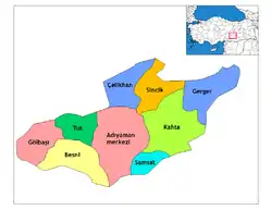 Districts of Adıyaman | ||||||||||||||||||||||||||
| |||||||||||||||||||||||||||
Metropolitan municipalities are bolded. | |||||||||||||||||||||||||||
This article is issued from Wikipedia. The text is licensed under Creative Commons - Attribution - Sharealike. Additional terms may apply for the media files.