Tuolumne Peak
Tuolumne Peak is a mountain, in Yosemite National Park, in the area of Tuolumne Meadows. It is a fractured granite, twin summited peak, and is close to geographic center of the park. Tuolumne Peak is located approximately 2.5 miles (4.0 km) northeast of Mount Hoffmann via a granite ridge-line. It is climbed less often than Hoffman, probably due to a more difficult approach.[2]
| Tuolumne Peak | |
|---|---|
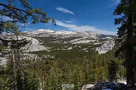 Mount Hoffman (L) and Tuolumne Peak (R) | |
| Highest point | |
| Elevation | 10,845 ft (3,306 m) NAVD 88[1] |
| Prominence | 685 ft (209 m)[1] |
| Coordinates | 37°52′31″N 119°29′5″W[1] |
| Geography | |
| Location | Yosemite National Park, California, U.S. |
| Geology | |
| Age of rock | Cretaceous |
| Mountain type | Granite |
| Climbing | |
| First ascent | Richard M. Leonard and Sierra Club party on July 9, 1932 |
The mountain is in Mariposa County.[3]
There is rock climbing, on Tuolumne Peak.[4]
Tenaya Glacier had effects, at least near Tuolumne Peak, during the Wisconsin Glacial Stage, over-topping the ridge that connects Tuolumne Peak to Mount Hoffman, isolating both tops.[5]
See also
References
- "Tuolumne Peak, California". Peakbagger.com. Retrieved 2019-02-05.
- keema. "Tuolumne Peak California, United States, North America". summitpost.org. Retrieved 31 January 2019.
- "Mount Hoffmann Topo Map in Mariposa County CA". topozone.com. Retrieved 31 January 2019.
- "Tuolumne Peak Rock Climbing". mountainproject.com. Retrieved 31 January 2019.
- "ANCIENT GLACIERS OF THE YOSEMITE REGION". NPS. November 28, 2006. Retrieved 31 January 2019.
This article is issued from Wikipedia. The text is licensed under Creative Commons - Attribution - Sharealike. Additional terms may apply for the media files.