British Columbia Highway 1
Highway 1 is the main route of the Trans-Canada Highway (TCH) through British Columbia, Canada. Its total accumulated distance through British Columbia is 1,039 km (646 mi), including the distance travelled on ferries. It is the westernmost portion of the "Highway 1" designation of the TCH through Western Canada, which extends to the Manitoba–Ontario boundary. The section of Highway 1 in the Lower Mainland is the second-busiest freeway in Canada, after the section of Ontario Highway 401 in Toronto.
.svg.png.webp) | ||||
|---|---|---|---|---|
| Trans-Canada Highway | ||||
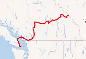 A map of southern British Columbia with Hwy 1 highlighted in red | ||||
| Route information | ||||
| Maintained by British Columbia Ministry of Transportation and Infrastructure | ||||
| Length | 1,047 km (651 mi) | |||
| Existed | 1941–present | |||
| Vancouver Island section | ||||
| Length | 116 km (72 mi) | |||
| South end | Dallas Road in Victoria | |||
| Major intersections | ||||
| North end | ||||
| Mainland section | ||||
| Length | 877 km (545 mi) | |||
| West end | ||||
| Major intersections | ||||
| East end | Alberta border at Kicking Horse Pass continues as | |||
| Location | ||||
| Country | Canada | |||
| Province | British Columbia | |||
| Highway system | ||||
|
| ||||
| ||||
Vancouver Island section
Route details
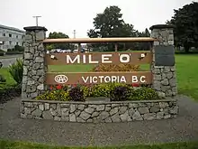
The Vancouver Island section of Highway 1, is 116 kilometres (72 mi) in total length and is known locally as the Island Highway (a name shared with Highway 19); it is the main thoroughfare on the south Island. Most of this section of Highway 1 is a heavily signalized four-lane route. Travellers between Victoria and Vancouver can save considerable time taking the ferry to Tsawwassen and driving the South Fraser Perimeter Road to connect back to Highway 1. The highway begins at the intersection of Douglas Street and Dallas Road in Victoria, where a large "mile zero" sign is erected. Highway 1 proceeds north through the city of Victoria as an urban arterial street for 4 kilometres (2.5 mi), passing by the southern terminus of Highway 17, before leaving the city at Tolmie Avenue. Once out of Victoria there are two at-grade intersections at Boleskine Road and Tillicum Road.
Highway 1 then continues on a 12-kilometre-long (7.5 mi) four-to-six-lane freeway, with seven interchanges along its length, one of which leads to the start of Highway 14. The freeway segment ends at the signalized intersection with Westshore Parkway. After the Westshore Parkway intersection, the highway narrows to two lanes as it enters Goldstream Provincial Park. The highway from this point is known locally as Malahat Drive.
From the southern entrance to Goldstream Provincial Park, the Malahat section of Highway 1, which is known for its steep grades, goes north for 20 km (12 mi). It follows the Goldstream River through the park to the west shore of Finlayson Arm, becomes three lanes on its exit from the park, and passes through the community of Malahat proper, as well as the Malahat Summit, the highest point on the Island section of Highway 1 at 352 m (1,155 ft), en route. The Malahat portion of the highway is a mix of two-, three- and four-lane cross-sections. The section between Tunnel Hill and Shawnigan Lake Road is four lanes. 65 per cent of the Malahat highway is divided with concrete median. The Malahat section ends when it reaches the community of Mill Bay.
In Mill Bay, Highway 1 once again widens out into four lanes (with an interchange at Mill Bay Road at Bamberton), then passes through signalized intersections at Butterfield Road, Frayne Road and Deloume Road. Highway 1 then travels north through a gauntlet of 15 traffic lights for 29 km (18 mi). These provide access to Shawnigan Lake (stoplights at Shawnigan Lake-Mill Bay Road), Cobble Hill (Cobble Hill Road, Hutchinson Road and Fisher Road), Cowichan Bay (Cowichan Bay Road, Koksilah Road, and Bench Road) and Duncan (closely spaced signals at Allenby Road, Boys Road, Trunk Road, Coronation Avenue, James Street, Beverly Street, Green Road, and Drinkwater Road). Next is a signalized junction with Highway 18. The highway then proceeds north for 10 km (6.2 mi) through stoplights at Mays Road and Mount Sicker Road to a signalized intersection at Henry Road serving Chemainus.
From the Chemainus junction, Highway 1 travels 11 km (6.8 mi) northwest to the city of Ladysmith accessed by intersections with traffic lights at Davis Road, Roberts Street, and Ludlow Road. It then continues northwest for another 13 km (8.1 mi) through signalized junctions at Oyster Sto-Lo Road, Cedar Road, Timberlands Road, and Spitfire Way, the last of which provides access to Nanaimo Airport. The highway then reaches an unsignalized junction at Cassidy. Immediately after crossing a bridge over the Nanaimo River, there is an interchange with Nanaimo River Road. There is then a signalized intersection at Morden Road. Highway 1 enters the City of Nanaimo about 6 km (3.7 mi) north of Cassidy, where Highway 19 merges at an interchange onto the highway from the B.C. Ferry terminal at Duke Point. The two highways follow a short freeway that reaches seven lanes at its widest point. It runs another 2 km (1.2 mi) north to a point where Highways 1 and 19 split off at a junction with Cedar Road. Highway 19 proceeds northwest to bypass Nanaimo, while Highway 1 continues north through the city of Nanaimo for 7 km (4.3 mi) to the B.C. Ferry terminal at Departure Bay, where the Island section of Highway 1 terminates.
Highway 1 then enters Departure Bay via ferry, turning east-northeast to enter the Strait of Georgia just north of Newcastle Island. The downtown core of Vancouver comes into view as the route approaches the entrance to Howe Sound. The highway then turns north-northeast just west of Passage Island to enter Queen Charlotte Channel, then rounds the Whytecliff Peninsula to enter the Horseshoe Bay ferry terminal, 57 km (31 nmi) from the Departure Bay dock.
History
The highway was first given the "1" designation in 1941, and originally went from Victoria to Kelsey Bay, a small coastal community north of Campbell River. Highway 1 on the Island was shortened to terminate in the downtown core of the city of Nanaimo in 1953, with the section north of Nanaimo being re-numbered 19. When BC Ferries took over the ferry route between Departure Bay in Nanaimo and Horseshoe Bay in West Vancouver in 1961, Highway 1 on the Island was extended to the Departure Bay ferry dock.
Lower Mainland section
Route details
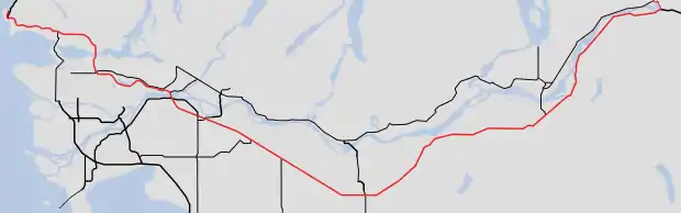
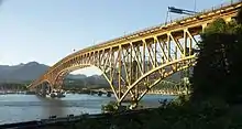
Highway 1's total length in the Lower Mainland is 170 km (110 mi). On the Mainland, the highway begins at the Horseshoe Bay ferry terminal in West Vancouver. From here to the Ironworkers Memorial Second Narrows Crossing, the highway is known locally as the Upper Levels Highway. There are nine interchanges on the 14 km (8.7 mi) stretch of the Highway within West Vancouver. The first interchange east of Horseshoe Bay brings Highway 99 onto a common alignment with Highway 1. After Taylor Way, where Highway 99 takes the exit off Highway 1, the highway crosses over the Capilano River into the District of North Vancouver. Highway 1 travels for 9 km (5.6 mi) through the District and the City of North Vancouver, passing through seven interchanges, until crossing the 1,292 m (4,239 ft) long Ironworkers Memorial Second Narrows Crossing over the Burrard Inlet into Vancouver. (The bridge, previously known as the Second Narrows Bridge, was renamed to commemorate the 27 workers who lost their lives during its construction.) This section of freeway is old and substandard lacking shoulders and proper merging lanes from on ramps.
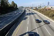
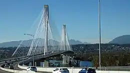
The 4-kilometre-long (2.5 mi) long stretch of Highway 1 through the eastern part of Vancouver is the only freeway within Vancouver's city limits. Highway 1 from Vancouver to Surrey is the busiest segment of the entire freeway in the Lower Mainland. In Vancouver, Highway 1 travels through the Cassiar Tunnel and passes through three interchanges leading to Downtown before crossing into Burnaby at the interchange with Boundary Road. The Burnaby stretch of Highway 1 is 11 km (6.8 mi) long, and goes through four interchanges around the city centre before proceeding into Coquitlam. The Coquitlam stretch is the widest segment in Western Canada of Highway 1. It lasts 7 km (4.3 mi), with two interchanges along its length, the westernmost of them also connecting to New Westminster. The easternmost interchange on Highway 1 in Coquitlam, known as the Cape Horn Interchange, leads to Highway 7 and Highway 7B. Leaving Coquitlam, Highway 1 crosses the Fraser River over the Port Mann Bridge into Surrey.
Sections of Highway 1 from Grandview Highway in Vancouver to 216 Street in Langley vary from being 3 to 4 lanes in each direction and shortens to two lanes after leaving Langley (Metro Vancouver) and enters Abbotsford (Fraser Valley). With one of these lanes being a high-occupancy vehicle (HOV) lane. These HOV lanes were constructed in 1998 as part of the BC MOT's "Go Green" project to promote the use of HOV vehicles, and cost $62 million.[1]
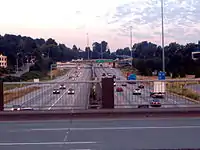
In Surrey, Highway 1 has five interchanges - 152 St (accessed by getting in rightmost lanes before the Port Mann Bridge eastbound), 156 St (HOV only), 160 St/104 Ave, one that connects to Highway 15 and Highway 17, and 192 St (eastbound exit/westbound entrance only). 12 km (7.5 mi) east of the Highway's entry into Surrey, the Highway crosses into the Township of Langley. There are five interchanges on Highway 1 in its 18-kilometre-long (11 mi) stretch through Langley. One leads to 200 St, Langley's major thoroughfare, an HOV-only interchange leads to 202 St, the next one is a recently completed connection to 216 St. After passing 216th the highways leaves the urbanized area and passes through the more rural parts of Langly, at that point the highway narrows from 3 to 2 lanes in each direction. Proceeding in a straight line Hwy 1 passes for long stretches between two more interchanges, a full cloverleaf interchange at Highway 10, and another full cloverleaf at Highway 13. The Hwy 10 and 13 interchanges are the only full cloverleaf interchanges still in use in all of B.C. The section of freeway between Abbotsford and the Langley urban area is prone to chronic traffic congestion due to the reduced number of lanes (4 total instead of 6), the large amount of semi trucks that travel this section and the lack of a nearby alternative route. On summer weekends or during rushhour the traffic on this stretch is often reduced to stop and go due to sheer traffic volume. Even at non peak hours this stretch can experience dense traffic forcing drivers to travel under 50 km/h.
Highway 1 then crosses from Metro Vancouver into the Fraser Valley Regional District upon entry into Abbotsford. There are six interchanges on Highway 1 in its 33-kilometre-long (21 mi) stretch through Abbotsford, one of which leads to Highway 11. Once Highway 1 leaves Abbotsford, it crosses over the Vedder Canal into Chilliwack. The highway goes through Chilliwack for 24 km (15 mi), passing through six interchanges within the city (Yale Road West, Lickman Road, Evans Road, Vedder Road, Prest Road, and Annis Road). An exit to Young Road is also available westbound on the highway.
2 km (1.2 mi) after leaving Chilliwack, Highway 1 reaches an interchange with Highway 9. East of the Highway 9 interchange, Highway 1 hugs the south bank of the Fraser River for 35 km (22 mi), passing through seven interchanges until reaching the interchange with Highway 3 at Hope, British Columbia. Highway 1 takes the exit off the freeway at this point. (The freeway alignments of Highways 3 and 5 continue from this exit, from Exit 170 Highway 5 continues as a freeway until it meets up again with Highway 1 just west of Kamloops at Exit 362.) The vast majority of traffic travelling between Hope and Kamloops follows Highway 5 as it takes over an hour and a half less time to travel when compared to following Highway 1, and that Highway 5 is a controlled-access freeway. As Highway 1 leaves the freeway it drops from a total of 4 lanes to 2.
History
Like its Island section, the Highway on the Lower Mainland was first given the "1" designation in 1941. Highway 1's original alignment started out within the city limits of Vancouver, and followed Kingsway from Vancouver to Surrey, and then went along the Fraser Highway to Clearbrook. From Chilliwack, the highway originally went to Rosedale, which is a community just east of Chilliwack, along Yale Road, then along Flood-Hope Road to where it picks up its current alignment just across the Fraser River from Hope.
In 1959, Highway 1 was given an extension from within Vancouver to Horseshoe Bay by way of the Lions' Gate Bridge and Taylor Way in West Vancouver. In 1962, the section between Clearbrook and Chilliwack was re-routed to a new expressway.
In 1964, the Clearbrook–Rosedale section of Highway 1 was restored to its original alignment. Also in that year, a new expressway (or "freeway"), originally designated as Highway 401, opened up on Highway 1's current alignment between West Vancouver and Rosedale. The expressway became part of Highway 1 in 1973.
In 1986, Highway 1 between Chilliwack and Hope was improved to a freeway. Through the 1990s, all signals and intersections on Highway 1 through Greater Vancouver were removed, making the entire section of Highway 1 between Horseshoe Bay and Hope a freeway.
On June 9, 2011, Highway 1 between 152 Street in Surrey and Highway 11 in Abbotsford was designated as the Highway of Heroes.[2]
Interior section
Route details
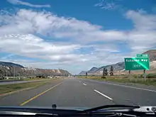
The Interior section of Highway 1 is 704 km (437 mi) long, accounting for over 70 percent of the total length of the highway. For most of the route, it roughly follows the path of the Canadian Pacific Railway. The highway climbs over four passes and summits between the Fraser Valley and Alberta: Eagle Pass (557 m), Rogers Pass (1330 m), Kinbasket Summit (1095 m) and Kicking Horse Pass (1627 m). After leaving the freeway, Highway 1 crosses through the town centre of Hope for 2 km (1.2 mi) before heading north across the Fraser River. At this point, Highway 1 becomes two lanes. 1 km (0.62 mi) north of the Fraser crossing, Highway 1 reaches its east junction with Highway 7. Continuing from the Highway 7 junction, Highway 1 enters the Fraser Canyon and travels for 106 km (66 mi) north on a route that includes seven mountain tunnels, past the communities of Yale, Spuzzum and Boston Bar, before reaching its junction with Highway 12 at Lytton. Leaving the Fraser River, and following the Thompson River another 37 km (23 mi) northeast, Highway 1 reaches a junction with Highway 8. 38 km (24 mi) north of the Highway 8 junction, Highway 1 passes through a junction with Highway 97C. Continuing 5 km (3.1 mi) north, the highway reaches the community of Cache Creek, where Highway 97 merges onto the Trans-Canada from the north. East of Cache Creek, Highways 1 and 97 proceed on their common alignment for 72 km (45 mi), passing through Savona en route to Kamloops. On the edge of Kamloops, the Trans-Canada Highway merges onto Highway 5 (Coquihalla Highway) at a trumpet interchange, returning Highway 1 to its freeway alignment (which through the Coquihalla Highway is a continuation of the same freeway Highway 1 travels on in the Lower Mainland).
The 1/97/5 concurrency proceeds east for 12 km (7.5 mi) mainly as a six-lane freeway through the western part of Kamloops passing through five interchanges. At the five-way Valleyview interchange Highway 5 exits the freeway and diverges north. Shortly after the Valleyview interchange the freeway ends and Highways 1 and 97, enter a four-lane arterial road lined with shopping malls and business. The highway passes through six sets of signal lights in 7 km (4.3 mi) before the freeway resumes and the highway exits Kamloops to the east. This 7 km-long arterial stretch is often one of the most congested areas on the Interior section of Highway 1, due to both the signal lights and Kamloops rush-hour traffic; there are no plans to address this gap in the freeway. Highway 1/97 returns to being a freeway just east of Kamloops, and continues for another 19 km (12 mi) past four interchanges until it reaches Monte Creek, where Highway 97 diverges south from Highway 1. However, despite the highway having at-grade intersections, there are no signal lights on Highway 1 between Monte Creek and Salmon Arm. The divided highway continues for another 19 km (12 mi) beyond Monte Creek until it ends and becomes a two-lane undivided route. For the next 58 km (36 mi) east, Highway 1 takes a winding two-lane route through the communities of Pritchard, Chase and Sorrento with the occasional passing lane. In several locations it travels right next to the South Thompson River, as well as the shores of Shuswap Lake and Little Shuswap Lake. The highway widens back out to a modern four-lane alignment just east of Sorrento for 11 km (6.8 mi) before it reverts to a narrow two-lane cross section for the final stretch to the city of Salmon Arm on Shuswap Lake. Eight sets of lights and a 50 km/h speed limit slowly move traffic through the city centre on a four-lane arterial road. However, unlike Kamloops, congestion is often not an issue on Highway 1 in Salmon Arm. Highway 97B meets Highway 1 at a signal light, 3 km east of Salmon Arm's city centre.
After Salmon Arm, Highway 1 continues east, still as a narrow two-lane winding highway, for 31 km (19 mi) to a signalized junction with Highway 97A at Sicamous, taking a route above the south shore of the Salmon Arm of Shuswap Lake for most of this stretch.
For the next 71 km (44 mi) between Sicamous and Revelstoke, the highway travels over the first major pass, Eagle Pass, which is a relatively low and gradual climb compared to what is farther east. The highway first continues relatively straight through agricultural land in the Eagle River Valley, past the communities of Malakwa and Craigellachie and crossing the Eagle River several times. It widens to a modern four-lane cross section twice in this area, first for a 3 km-long stretch, followed shortly afterwards by an 11 km-long stretch. After returning to two lanes, the Highway climbs out of the flats into a narrow and curvy valley through the Monashee Mountains. The highway passes many lakes, with the largest being at Three Valley Gap. The steep valley walls in the region mean that this section is often subject to avalanche closures in the winter, despite its relatively low elevation. The highway then crosses Eagle Pass and relatively quickly descends down into the Columbia Valley. It then reaches a signalized junction with Highway 23 before crossing a suspension bridge across the Columbia River and entering Revelstoke. The main part of the town is accessed through two signal lights. Higher up the hill, an interchange provides access to the Meadows in the Sky Parkway to the north, while two stop-controlled intersections provide direct access to the south end of Revelstoke.
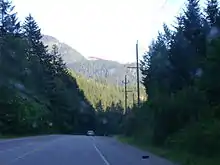
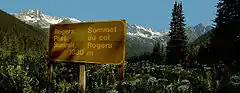
The next 148 km (92 mi) of Highway 1, through the Selkirk Mountains en route to Golden, winds east through Mount Revelstoke National Park and Glacier National Park, where Rogers Pass is located. There are no significant settlements between Revelstoke and Golden. The highway climbs gradually at first, passing through both parks and an area known as Albert Canyon. Occasional turn-offs provide access to trailheads and park attractions, wildlife including grizzly bears and mountain goats are often seen by the road in this section. Right before Rogers Pass, the road goes around a sharp corner and approaches an extremely steep grade as a final climb towards the pass. Prior to this corner being twinned, it was an extremely dangerous spot, as vehicles going down hill often lost control and slid into oncoming traffic. Trucks often navigate this area going as slow as 10 km/h in order to manage the climb or safely descend in control. The top of the pass is narrow and towered over by a ring of spectacular peaks, but is often clouded over. The steep narrow sides cause the highway to pass through a gauntlet of avalanche paths; eight snow sheds provide coverage on the most active avalanche paths. The pass is also the boundary between the Pacific and Mountain time zones. After exiting the pass, the highway descends down a long, but more gentle hill, into the Beaver River Valley. The highway then travels relatively straight until it passes through the east gate of Glacier National Park. Shortly after exiting Glacier National Park, the highway climbs steadily over a long distance to Kinbasket Summit. Although it continues at high elevation for a long distance, it soon abruptly drops into the Columbia River Valley. When approaching from the east, this is the longest steep climb on the whole of the Trans Canada highway, at 4 km, usually bringing semi trucks to a crawl. At the bottom of the hill the highway crosses the Columbia River and passes through the ghost town of Donald. From there it proceeds relatively straight, along the Columbia River, until reaching Golden. Motorists are advised to check their fuel level leaving either Revelstoke or Golden, as there are no refuelling facilities between the two towns. With the exception of two small 2 km-long four-lane divided fragments, this section of Highway 1 is almost exclusively an undivided two-lane road, with climbing lanes in steep areas. Accidents are common on this section, especially in the winter, resulting particularly from dangerous yellow line passing, excessive speeding, animals crossing the road, and icy conditions. Since this section passes through a remote area, there is little cell reception en route. Avalanches in areas where there are no snow sheds lead to frequent road closures while crews clear or blast avalanches after a storm, with such closures lasting anywhere from a few hours to a few days.
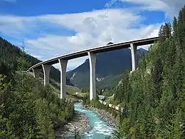
Travellers entering Golden encounter two signal lights, serving many gas stations, hotels and restaurants on both side of the highway. It then reaches an important seagull intersection with Highway 95 which gives access to the south part of Golden including its small downtown. The highway then climbs out of the town and the Columbia Valley, passes through one final interchange on the outskirts of the town, before entering the Kicking Horse Canyon section of the highway, commonly called the "Golden Stairs" by locals. The 23 km (14 mi) Kicking Horse Canyon stretch of Highway 1 between Golden and the boundary of Yoho National Park was one of the most treacherous stretches of highway in North America. Recent improvements, starting in the early 2000s, have upgraded the majority of this section to a modern four-lane highway, entailing blasting a cutting in a mountain and building several large bridge spans, the largest being the Park Bridge. This significantly improved safety, as well as cut travel times through the canyon by about half. As of 2020, all but 4 km of the 23 km-long canyon section has been upgraded. However, the final 4 km still remains one of the most dangerous highways in BC, being a narrow two-lane winding route hugging a cliff edge with extremely steep grades and average travel speeds of about 40 km/h. Rockfalls, avalanches and accidents frequently close this 4 km section. Upgrading this final section to a modern four-lane standard is expected by 2024.[3] The Kicking Horse Canyon is considered to be most scenic section of the entire highway. Bighorn sheep and mountain goats frequent this section. To address this issue, wildlife fences and overpasses are included in all the new four-lane sections. After exiting the canyon, Highway 1 enters Yoho National Park, returning to a two-lane cross section with the occasional passing lane. The highway closely follows the Kicking Horse River and soon arrives at the community of Field. Highway 1 then climbs up the Big Hill towards the Continental Divide at Kicking Horse Pass. At the top of the hill, the highway widens to four lanes and skirts the edge of Wapta Lake. It soon crosses over into Alberta and into Banff National Park at the pass itself, where a rest area is located. Since Kicking Horse Pass is wider than both Eagle Pass and Rogers Pass, avalanches are not an issue on this section of highway, despite it being one of the highest roads in British Columbia. As the highway crosses the pass it enters Alberta and continues as a four-lane highway towards Banff and Calgary as Alberta Highway 1.
History
In the Selkirk Mountains, Highway 1 originally went around the Rogers Pass area by following the Columbia River between Revelstoke and Golden along what was known as the Big Bend Highway. This route was largely gravel for most of existence. In 1962, the section of Highway between Revelstoke and Golden was re-routed through Rogers Pass. This realignment reduced the travelling distance between the two towns by more than 160 km (99 mi). The Big Bend highway was renumbered as Highway 23 and continued to provide an alternative route between the two towns until a large portion of it was flooded under Kinbasket Lake after the construction of the Mica Dam. Over the 1970s and 1980s, Highway 1's alignment between Hope and Cache Creek underwent a massive overhaul, including new tunnels, river spans and passing lanes. Although not part of Highway 1, the opening of the Coquihalla Highway in 1986 also played an important role in the highway's function between Hope and Kamloops. Since the Coquihalla was a freeway and a much faster and safer route between Hope and Kamloops, it drained a lot of the traffic out of the Fraser Canyon section, which was reduced to mainly a secondary scenic route into the interior region. This led to a decline and disappearance of many business in the Fraser Canyon area including the towns of Yale, Lytton, Spences Bridge and Cache Creek. This situation is similar to the well-known example of Interstate 40 draining traffic off U.S. Route 66 causing many of the business in towns along Route 66 to disappear after the opening of the freeway. In near conjunction with the 1987 opening of the second phase of the Coquihalla Highway, a freeway bypass was constructed to re-route traffic on Highway 1 and Highway 5 around the downtown area of Kamloops. Starting in 2004 the highway had a massive overhaul in the Kicking Horse Canyon near Golden including a 5 km realignment.[4] Smaller realignments and bypasses have been constructed over the years in various locations as the highway was upgraded to four lanes.
During major floods in November 2021, sections of Highway 1 between Hope and Spences Bridge were washed away into the Thompson River. Other sections of the highway on Vancouver Island and a railroad underpass near Lytton were also damaged in the same event. As a result of the floods, which also damaged other highways in the Fraser Valley, road connections from Metro Vancouver to the rest of Canada were cut off.[5]
Future
The Interior section of Highway 1 is considered sub-standard when compared to other highways with similar traffic volume in the U.S. or other parts of Canada. The majority of the route is a dangerous, undivided two-lane highway with sharp corners, prone to frequent closures and accidents. To address this, the Ministry of Transportation and Infrastructure has undertaken an effort to twin the highway to four-lane 100 km/h standards between Kamloops and Alberta, with a targeted completion date of 2050. Several stretches of four-lane divided highway, including the Monte Creek to Pritchard section; the four-lane portions of the Kicking Horse Canyon, the 13 km-long passing lanes near Blind Bay, and many smaller four-lane divided fragments typically 2–4 km in length, are the results of this effort. As of 2020, about 25 percent of the highway between Alberta and Kamloops has been upgraded to a divided four-lane cross-section. Several new projects have been funded in the latest budget cycle, including the following:
- A new 4.9 km-long four-lane divided section around Chase, involving the construction of an interchange at the town;
- A new interchange and twinned highway at the West entrance of Salmon Arm;
- A new four-lane bridge across the Shuswap River in Sicamous;
- A new rest area and a 2 km-long four-lane section in the Illecillewaet Valley;
- A 4.4 km-long twinning near Quartz Creek east of Golden;
- And upgrading the remaining 4 km-long stretch of two-lane highway in the Kicking Horse Canyon.
All of this is expected to be constructed over the next 3 years.[6]
Major intersections
| Regional District | Location | km[7] | mi | Exit | Destinations | Notes |
|---|---|---|---|---|---|---|
| Capital | Victoria | 0.00 | 0.00 | Dallas Road | Western terminus and mile zero of Trans-Canada Highway; south end of Douglas Street | |
| 1.20 | 0.75 | Northbound right-in/right-out; BC Ferries to Vancouver (Tsawwassen) and Gulf Islands | ||||
| 1.30 | 0.81 | Black Ball Ferries to Port Angeles; Victoria Clipper passenger ferry to Seattle | ||||
| 2.10 | 1.30 | Johnson Street | One-way eastbound; access from Johnson Street Bridge | |||
| 2.20 | 1.37 | Pandora Avenue | One-way westbound; access to Johnson Street Bridge | |||
| 3.10 | 1.93 | Bay Street | ||||
| 3.40 | 2.11 | Gorge Road, Hillside Avenue, Government Street | Former Hwy 1A north | |||
| ↑ / ↓ | 4.50 | 2.80 | Tolmie Avenue; north end of City of Victoria jurisdiction | |||
| Saanich | 5.10 | 3.17 | Saanich Road, Boleskine Road | North end of Douglas Street | ||
| 6.44 | 4.00 | Tillicum Road | At-grade intersection, signalized; south end of freeway | |||
| 6.79 | 4.22 | Burnside Road, Interurban Road | Southbound exit only | |||
| 7.52 | 4.67 | 6 | McKenzie Avenue Interchange [8] | |||
| View Royal | 9.59 | 5.96 | 8 | Helmcken Road | Helmcken Road Interchange | |
| 11.30 | 7.02 | 10 | Colwood (Island Highway, Burnside Road) | Colwood Interchange Northbound exit and southbound entrance; former Hwy 1A south | ||
| 12.24 | 7.61 | 11 | Colwood (Six Mile Road) | Thetis Interchange Southbound exit and northbound entrance | ||
| Langford | 15.29 | 9.50 | 14 | Millstream Road Interchange | ||
| 15.94 | 9.90 | 15 | McCallum Road | Northbound exit only | ||
| 16.77 | 10.42 | 16 | Leigh Road/Bear Mountain Parkway | Bear Mountain Interchange | ||
| 18.29 | 11.36 | (18) | Westshore Parkway | At-grade, signalized; north end of freeway | ||
| Cowichan Valley | | 37.88 | 23.54 | (38) | Bamberton Interchange | |
| 40.95 | 25.45 | Butterfield Road | ||||
| Mill Bay | 42.68 | 26.52 | Frayne Road | |||
| 43.93 | 27.30 | |||||
| 44.47 | 27.63 | Shawnigan / Mill Bay Road – Shawnigan Lake | ||||
| | 45.31 | 28.15 | Cobble Hill Road, Kilmalu Road | |||
| 48.17 | 29.93 | Hutchinson Road – Cobble Hill, Arbutus Ridge | ||||
| 49.55 | 30.79 | Fisher Road | ||||
| 51.36 | 31.91 | Cobble Hill Road, Cowichan Bay Road – Cobble Hill, Cowichan Bay | ||||
| 55.24 | 34.32 | Koksilah Road | ||||
| 57.31 | 35.61 | Bench Road | ||||
| 59.19 | 36.78 | Wilson Road, Cowichan Bay Road – Cowichan Bay | no left turns onto highway. no left turn onto Wilson | |||
| Cowichan First Nation (Koksilah) | 61.01 | 37.91 | Allenby Road, Chaster Road | |||
| 61.56 | 38.25 | Boys Road | ||||
| Duncan | 62.35 | 38.74 | Trunk Road – City Centre, Maple Bay | |||
| 62.56 | 38.87 | Coronation Street | ||||
| North Cowichan | 62.95 | 39.12 | James Street | |||
| 63.66 | 39.56 | Beverley Street | ||||
| 65.74 | 40.85 | Drinkwater Road | ||||
| 67.24 | 41.78 | |||||
| 69.41 | 43.13 | Mays Road | ||||
| 74.04 | 46.01 | Hwy 1A is unsigned | ||||
| 78.42 | 48.73 | |||||
| Ladysmith | 84.85 | 52.72 | Thicke Road, Edgelow Road | |||
| 88.19 | 54.80 | Chemainus Road, Davis Road (Hwy 1A south) | Hwy 1A is unsigned | |||
| 90.23 | 56.07 | Roberts Street, Transfer Beach Boulevard | ||||
| 91.16 | 56.64 | First Avenue | ||||
| Stz'uminus First Nation | 94.13 | 58.49 | Oyster Sto'Lo Road | |||
| | 96.54 | 59.99 | Cedar Road – Yellow Point, Cedar | |||
| Nanaimo | Cassidy | 98.02 | 60.91 | Timberlands Road | At-grade intersection, signalized | |
| 98.98 | 61.50 | |||||
| 101.38 | 62.99 | (102) | Nanaimo River Road, Fry Road | Nanaimo River Road Interchange | ||
| 103.52 | 64.32 | Morden Road | ||||
| Nanaimo | 105.75 | 65.71 | 7[lower-alpha 1] (106) | Duke Point Interchange South end of Hwy 19 concurrency; BC Ferries to Vancouver (Tsawwassen) | ||
| 107.69 | 66.92 | 9[lower-alpha 2] (108) | North end of Hwy 19 concurrency Partial-at grade intersection with northbound flyover to Hwy 19 north. | |||
| 108.13 | 67.19 | Cranberry Avenue | ||||
| 108.48 | 67.41 | 10th Street, Maki Road | ||||
| 112.35 | 69.81 | |||||
| 113.33 | 70.42 | Comox Road | ||||
| 113.61 | 70.59 | Stewart Avenue | Hwy 1 branches northeast. | |||
| 115.67 | 71.87 | |||||
| Strait of Georgia | ||||||
| Metro Vancouver | West Vancouver | 0.00 | 0.00 | Access via BC ferries; westbound access only | ||
| 0.35 | 0.22 | Keith Road | At-grade intersection, no westbound entrance; west end of freeway | |||
| 0.61 | 0.38 | 0 | Marine Drive | Horseshoe Bay Interchange Eastbound exit only | ||
| 1.84 | 1.14 | 2 | Eagleridge Drive to Marine Drive | Squamish Interchange Eastbound exit only; eastbound access to Hwy 99; westbound access via Hwy 99 | ||
| 2.21 | 1.37 | 3 | Eagle Ridge Interchange Westbound exit and eastbound entrance; west end of Hwy 99 concurrency; westbound Hwy 1 uses exit 3 | |||
| 4.29 | 2.67 | 4 | Woodgreen Drive, Headland Drive | |||
| 6.95 | 4.32 | 7 | Wentworth Avenue, Westmount Road | |||
| 8.54 | 5.31 | 8 | Cypress Bowl Road | To Cypress Mountain Ski Area | ||
| 9.94 | 6.18 | 10 | 22nd Street | Eastbound exit only | ||
| 10.59 | 6.58 | 10 | 21st Street, Westhill Drive | No eastbound exit | ||
| 11.46 | 7.12 | 11 | 15th Street | |||
| 13.15 | 8.17 | 13 | East end of Hwy 99 concurrency; former Hwy 1A east; to Lions Gate Bridge and Downtown Vancouver | |||
| North Vancouver (District) | 14.59 | 9.07 | 14 | Capilano Road | To Grouse Mountain | |
| 15.51 | 9.64 | 15 | Lloyd Avenue | Westbound right-in/right-out | ||
| North Vancouver (City) | 16.75 | 10.41 | 17 | Westview Drive | ||
| 17.92 | 11.13 | 18 | Lonsdale Avenue | |||
| North Vancouver (District) | 19.40 | 12.05 | 19 | Lynn Valley Road | ||
| 21.37 | 13.28 | 21 | Mountain Highway | Signed as exit 22A for Hwy 1 west exiting before Lynn Creek Bridge | ||
| 22.17 | 13.78 | 22 | Mount Seymour Parkway, Lillooet Road | |||
| 22.88 | 14.22 | 23 | Main Street, Dollarton Highway | Signed as exits 23A (Main Street) and 23B (Dollarton Highway) from Hwy 1 west | ||
| ↑ / ↓ | 23.09– 24.42 | 14.35– 15.17 | Ironworkers Memorial Second Narrows Crossing over Burrard Inlet | |||
| Vancouver | 25.03 | 15.55 | 25 | McGill Street | ||
| 26 | Hastings Street | Eastbound exit and westbound entrance; exits onto Cassiar Connector; former Hwy 7A | ||||
| 25.39– 26.13 | 15.78– 16.24 | Cassiar Tunnel | ||||
| 26.32 | 16.35 | 26 | Hastings Street | Westbound exit and eastbound entrance; exits onto Cassiar Connector; former Hwy 7A | ||
| 27.06 | 16.81 | 27 | 1st Avenue, Rupert Street | |||
| ↑ / ↓ | 28.02 | 17.41 | 28 | Boundary Road | Eastbound to southbound exit; northbound to westbound entrance | |
| Burnaby | 28.44 | 17.67 | 28A | Grandview Highway | Westbound exit and eastbound entrance | |
| 28B | Grandview Highway | HOV-only interchange (left exit/entrance), westbound exit and eastbound entrance | ||||
| West end of HOV lanes | ||||||
| 29.64 | 18.42 | 29 | Willingdon Avenue | |||
| 32.26 | 20.05 | 32 | Sprott Street | Eastbound exit, westbound entrance | ||
| 33.11 | 20.57 | 33 | Kensington Avenue, Canada Way | No access from Hwy 1 east to Kensington Avenue north | ||
| 37.38 | 23.23 | 37 | Gaglardi Way | To Simon Fraser University | ||
| 39.11 | 24.30 | 38 | Government Street | Transit-only interchange (left exit/entrance); westbound exit and eastbound entrance | ||
| Coquitlam | 40.55 | 25.20 | 40 | Brunette Avenue | To New Westminster and Pattullo Bridge | |
| 43.68 | 27.14 | 44 | Cape Horn Interchange | |||
| Eastbound exit and westbound entrance; westbound exit via Hwy 7 east | ||||||
| ↑ / ↓ | 44.89– 46.91 | 27.89– 29.15 | Port Mann Bridge over Fraser River | |||
| Surrey | 48.26 | 29.99 | 48 | 152 Street – Surrey City Centre | Eastbound exit and westbound entrance; west end of Highway of Heroes | |
| 49.18 | 30.56 | 49 | 156 Street | HOV-only interchange (left exit) | ||
| 50.10 | 31.13 | 50 | 104 Avenue, 160 Street – Surrey City Centre | Former toll centre for Port Mann Bridge | ||
| 53.47 | 33.22 | 53 | BC Ferries to Victoria (Swartz Bay) and Nanaimo (Duke Point) | |||
| 56.79 | 35.29 | 57 | 192 Street north to unsigned Hwy 916 | Eastbound exit and westbound entrance; no access to/from 192 Street south of interchange; eastbound access to the Golden Ears Bridge | ||
| Langley (Township) | 58.62 | 36.42 | 58 | 200 Street – Langley City Centre to unsigned Hwy 916 | Westbound access to the Golden Ears Bridge | |
| 59.32 | 36.86 | 59 | 202 Street | HOV-only interchange (left exit)[9] | ||
| 62.12 | 38.60 | 61 | 216 Street | To Trinity Western University. Opened in September 2020.[9][10] | ||
| East end of HOV lanes | ||||||
| 65.73 | 40.84 | 66 | ||||
| 73.25 | 45.52 | 73 | ||||
| Fraser Valley | Abbotsford | 82.89 | 51.51 | 83 | Former Hwy 1A west | |
| 86.65 | 53.84 | 87 | Clearbrook Road | |||
| 90.21 | 56.05 | 90 | McCallum Road | |||
| 92.96 | 57.76 | 92 | Closest the Trans-Canada Highway gets to the US border in Western Canada; east end of Highway of Heroes | |||
| 95.51 | 59.35 | 95 | Whatcom Road | |||
| 98.98 | 61.50 | 99 | South Parallel Road | Eastbound only | ||
| 104.52 | 64.95 | 104 | No 3 Road – Yarrow, Cultus Lake | |||
| Chilliwack | 110.16 | 68.45 | 109 | Yale Road West | ||
| 116.05 | 72.11 | 116 | Lickman Road | |||
| 118.19 | 73.44 | 118 | Evans Road | Eastbound exit, westbound entrance | ||
| 119.36 | 74.17 | 119 | Vedder Road | Sardis Interchange; former Hwy 1A east | ||
| 120.53 | 74.89 | 120 | Young Road | Westbound exit, eastbound entrance | ||
| 122.79 | 76.30 | 123 | Prest Road | |||
| 129.21 | 80.29 | 129 | Annis Road | |||
| | 135.29 | 84.07 | 135 | |||
| 138.07 | 85.79 | 138 | Popkum Road – Popkum, Bridal Falls | |||
| 146.35 | 90.94 | 146 | Herrling Island | |||
| 151.54 | 94.16 | 151 | Peters Road | |||
| 153.72 | 95.52 | 153 | Laidlaw Road – Jones Lake | |||
| Hope | 160.09 | 99.48 | 160 | Hunter Creek Road, St. Elmo Road | ||
| 164.76 | 102.38 | 165 | Flood-Hope Road – Hope Business Route | |||
| 167.98 | 104.38 | 168 | Flood-Hope Road | |||
| 170.36 | 105.86 | 170 | Hwy 1 exits freeway and branches north; exit numbers continue along Hwy 5; eastbound exit and westbound entrance | |||
| 171.05 | 106.29 | Old Hope-Princeton Way (Hwy 915:1300 east) | Hwy 915:1300 is unsigned; westbound (southbound) access to Hwy 3 / Hwy 5 | |||
| 172.87 | 107.42 | Water Avenue Bridge across the Fraser River | ||||
| 174.26 | 108.28 | Haig interchange | ||||
| | 196.72 | 122.24 | Yale Tunnel | |||
| 200.70 | 124.71 | Saddle Rock Tunnel | ||||
| 206.96 | 128.60 | Sailor Bar Tunnel | ||||
| 214.89 | 133.53 | Alexandra Bridge across the Fraser River | ||||
| 218.90 | 136.02 | Alexandra Tunnel | ||||
| 223.58 | 138.93 | Hell's Gate Tunnel | ||||
| 223.90 | 139.13 | Ferrabee Tunnel | ||||
| 228.74 | 142.13 | China Bar Tunnel | ||||
| Boston Bar | 236.17 | 146.75 | Boston Bar Station Road – North Bend | |||
| Thompson-Nicola | Lytton | 279.51 | 173.68 | |||
| Spences Bridge | 315.11 | 195.80 | ||||
| 315.68 | 196.15 | Spences New Bridge across the Thompson River | ||||
| | 354.17 | 220.07 | Hwy 926:0901 is unsigned | |||
| 360.17 | 223.80 | South end of Hwy 97C concurrency | ||||
| Cache Creek | 364.35 | 226.40 | Hwy 1 branches east; north end of Hwy 97C concurrency; west end of Hwy 97 concurrency | |||
| Savona | 400.38 | 248.78 | Savona Bridge (Kamloops Lake Bridge) across the Thompson River | |||
| Kamloops | 436.34 | 271.13 | 362 | West end of Hwy 5 concurrency; Hwy 1 / Hwy 97 enters freeway; exit numbers continue from Hwy 5 | ||
| 440.57 | 273.76 | 366 | Copperhead Drive, Lac le Jeune Road | |||
| 442.25 | 274.80 | 367 | Pacific Way | |||
| 443.04 | 275.29 | 368 | Aberdeen Interchange | |||
| 444.34 | 276.10 | 369 | Columbia Street – City Centre | Sagebrush Interchange Eastbound exit, westbound entrance | ||
| 444.92 | 276.46 | 370 | Summit Drive – City Centre | Springhill Interchange Westbound exit, eastbound entrance | ||
| 448.41 | 278.63 | 374 | Yellowhead Interchange East end of Hwy 5 concurrency | |||
| 448.86 | 278.91 | 375 | Battle Street – City Centre | Valleyview Interchange No eastbound exit; east end of freeway | ||
| 450.09 | 279.67 | Vicars Road | ||||
| 451.92 | 280.81 | Oriole Road | ||||
| 451.73 | 280.69 | Highland Road | ||||
| 452.47 | 281.15 | River Road | ||||
| 453.42 | 281.74 | Tanager Road | ||||
| 454.28 | 282.28 | Grand Boulevard | ||||
| 457.49 | 284.27 | 384 | Kipp Road, Dallas Drive, Barnhartvale Road | Interchange | ||
| 462.14 | 287.16 | 386[lower-alpha 3] 388[lower-alpha 4] | Kokanee Way | O'Connor Interchange | ||
| 465.83 | 289.45 | 390[lower-alpha 3] 391[lower-alpha 4] | Lafarge Road | Interchange | ||
| | 471.86 | 293.20 | 396[lower-alpha 3] 397[lower-alpha 4] | Hook Road | Interchange; westbound access to Hwy 97 south (U-turn) | |
| 474.41 | 294.78 | 399 | Monte Creek Interchange East end of Hwy 97 concurrency; no westbound exit | |||
| 485.72 | 301.81 | 411 | Pritchard (Pinantan Road, Stoney Flats Road) | Interchange | ||
| Chase | 501.68 | 311.73 | Shuswap Avenue (Business route) | |||
| 502.60 | 312.30 | Brooke Drive | Interchange under construction[11] | |||
| 504.06 | 313.21 | Shuswap Avenue (Business route) | ||||
| Columbia-Shuswap | | 513.21 | 318.89 | Squilax-Anglemont Road (Hwy 922:0943 north) – Adams Lake, Scotch Creek, Anglemont | Partially grade separated; Hwy 922:0943 is unsigned | |
| Sorrento | 522.30 | 324.54 | Notch Hill Road | |||
| Blind Bay | 528.22 | 328.22 | Golf Course Drive, Cedar Drive | Interchange | ||
| | 531.83 | 330.46 | Balmoral Road, Notch Hill Road | |||
| 534.04 | 331.84 | Broderick Creek Frontage Road, White Creek Frontage Road | Grade separated; right-in/right-out | |||
| 535.44 | 332.71 | Broderick Creek Frontage Road, Carlin Road | Grade separated; eastbound right-in/right-out | |||
| 535.76 | 332.91 | White Lake Road | Grade separated; westbound right-in/right-out | |||
| Salmon Arm | 551.77 | 342.85 | Salmon River Road (Hwy 922:1126 south) | Interchange under construction[12] | ||
| 557.49 | 346.41 | 21st Street NE | Eastbound exit and entrance | |||
| 557.92 | 346.68 | 11th Avenue NE (to 21st Street NE) | Westbound exit and entrance | |||
| 558.21 | 346.86 | 30th Street NE | ||||
| 559.84 | 347.87 | |||||
| Sicamous | 586.68 | 364.55 | ||||
| Revelstoke | 656.38 | 407.86 | West end of Hwy 23 concurrency | |||
| 656.93 | 408.20 | Revelstoke Bridge across the Columbia River | ||||
| 657.39 | 408.48 | Victoria Road – City Centre | ||||
| 657.82 | 408.75 | East end Hwy 23 concurrency | ||||
| | 658.73 | 409.32 | Meadows-in-the-Sky Parkway – Mount Revelstoke National Park | Interchange | ||
| Mount Revelstoke National Park | | 675.38– 687.60 | 419.66– 427.25 | Passes through Mount Revelstoke National Park | ||
| Columbia-Shuswap | | 703.17 | 436.93 | Jack MacDonald Snowshed | ||
| 704.02 | 437.46 | Twins Snowshed | ||||
| 704.78 | 437.93 | Lanark Snowshed | ||||
| Glacier National Park | | 705.41 | 438.32 | West end of Glacier National Park | ||
| 725.27 | 450.66 | Rogers Pass – 1,330 m (4,360 ft) | ||||
| 729.56 | 453.33 | Bench Snowshed | ||||
| 730.46 | 453.89 | Len's Snowshed | ||||
| 730.96 | 454.20 | Tupper #1 Snowshed | ||||
| 731.75 | 454.69 | Tupper #2 Snowshed | ||||
| 732.33 | 455.05 | Tupper Timber Snowshed | ||||
| 749.90 | 465.97 | East end of Glacier National Park | ||||
| Columbia-Shuswap | | East end of Pacific Time Zone • West end of Mountain Time Zone | ||||
| 779.63 | 484.44 | Donald Bridge across the Columbia River | ||||
| Golden | 806.13 | 500.91 | To Kicking Horse Resort ski area | |||
| 807.53 | 501.78 | 780 | Golden View Road, Golden Donald Upper Road, Lafontaine Road | Interchange | ||
| | 818.44 | 508.56 | Park Bridge across the Kicking Horse River | |||
| 830.22 | 515.87 | Wapta Road, Beaverfoot Road | Interchange | |||
| Yoho National Park | | 830.65 | 516.14 | West end of Yoho National Park | ||
| Field | 860.09 | 534.44 | Field Access Road | |||
| | 873.42 | 542.72 | Lake O'Hara Road | Former Hwy 1A | ||
| 877.29 | 545.12 | Kicking Horse Pass – 1,627 m (5,338 ft) | ||||
| Continental Divide; continues into Alberta and Banff National Park | ||||||
1.000 mi = 1.609 km; 1.000 km = 0.621 mi
| ||||||
References
- "Frontier to Freeway – A short illustrated history of the roads in British Columbia". British Columbia Ministry of Transportation. Retrieved October 22, 2009.
- TranBC (June 9, 2011). "Highway of Heroes". Ministry of Transportation and Infrastructure. Government of British Columbia. Retrieved March 9, 2018.
- https://www.kickinghorsecanyon.ca
- "Previous Phases". Kicking Horse Canyon Project. Archived from the original on January 17, 2021. Retrieved April 1, 2021.
- "Coquihalla Highway and sections of Hwy 1 closed due to major flood damage". CBC News. November 15, 2021. Retrieved November 19, 2021.
- "Highway 1 - Kamloops to Alberta - Four Laning - Province of British Columbia". September 12, 2019.
- Landmark Kilometre Inventory (PDF). British Columbia Ministry of Transportation and Infrastructure (Report). Cypher Consulting. July 2016. pp. 399–402. Archived from the original (PDF) on March 11, 2017. Retrieved March 13, 2017.
- Trans-Canada traffic free-flowing at McKenzie interchange
- "Highway 1 and 216th Interchange Project". Ministry of Transportation and Infrastructure. Province of British Columbia. Retrieved March 8, 2017.
- New 216th Street-freeway interchange opens
- "Highway 1 - Chase West to Chase Creek Bridge - Province of British Columbia". Ministry of Transportation and Infrastructure. Province of British Columbia. Retrieved October 18, 2021.
- "Highway 1 - Salmon Arm West". Ministry of Transportation and Infrastructure. Province of British Columbia. Retrieved October 18, 2021.
External links
![]() Media related to British Columbia Highway 1 at Wikimedia Commons
Media related to British Columbia Highway 1 at Wikimedia Commons
Portions of the Trans-Canada Highway system | ||
|---|---|---|
| British Columbia | ||
| Alberta | ||
| Saskatchewan | ||
| Manitoba | ||
| Ontario | ||
| Quebec | ||
| New Brunswick | ||
| Prince Edward Island | ||
| Nova Scotia | ||
| Newfoundland | ||
| ||