Thorncliffe Park
Thorncliffe Park is a neighbourhood in Toronto, Ontario, Canada, in the former Borough of East York.
Thorncliffe Park | |
|---|---|
Neighbourhood | |
 | |
 The northwest portion is only sometimes considered part of Thorncliffe Park | |
| Coordinates: 43°42′17″N 79°20′47″W | |
| Country | |
| Province | |
| City | Toronto |
| Community | Toronto & East York |
| Changed Municipality | 1998 Toronto fromEast York |
| Government | |
| • MP | Rob Oliphant (Don Valley West) |
| • MPP | Kathleen Wynne (Don Valley West) |
| • Councillor | Jaye Robinson (Ward 15 Don Valley West) |
History


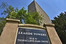
The site of Thorncliffe Park was a farm owned by Robert T. Davies, the wealthy founder of the Dominion Brewing Co. An avid participant in horse racing, under the banner of Thorncliffe Stable, he raced both Thoroughbred and Standardbred horses. After Davies' death in 1916 his estate sold the property to a group of investors from Baltimore, Maryland who built the Thorncliffe Park Raceway racetrack. The track was home to thoroughbred horse racing and harness racing from 1917 until 1952 when it was sold for real estate development. Today, the old racetrack site is commemorated by two streets named Grandstand Place and Milepost Place and the number of buildings that took on racetrack stable names like Churchill, Maple Glen and Wellow Glen.
In the 1950s, developers tore down the racetrack and created one of Toronto's first high-rise neighbourhoods. The neighbourhood embodies some standard urban planning ideas of the era – high concentrations of similar housing types, strict separation of retail and residential development, and the assumption that everyone has a car. Low-rise buildings are clustered inside the enclosure created by Thorncliffe Park and Overlea, while high-rise buildings line the outside of Thorncliffe Park. Retail establishments were concentrated in a single shopping mall, now called the East York Town Centre, between the two arms of Thorncliffe Park Drive at Overlea Boulevard. Smaller retail and service plazas have recently opened along Overlea Boulevard. Many residents on Thorncliffe Park Drive are at considerable walking distance from shops, although this problem is mitigated somewhat, even in winter, by well kept sidewalks and walkways and by frequent bus service.
Street names
Some of Thorncliffe Park's street names commemorate a former racetrack located there, or recognize the Town of Leaside's role in the development of the new community.[1]
- Leaside Park Drive - named in 1966, six months before the Town of Leaside's amalgamation into the Borough of East York.[2]
- Beth Nealson Drive - named for the last mayor of the Town of Leaside.[3][4]
- William Morgan Drive - named for Leaside's reeve from 1948 to 1950.[5]
- Banigan Drive - named for an elected member of Town of Leaside's Council from 1951 to 1955.[6] Banigan was defeated by Charles H. Hiscott in the 1955 election to replace retiring mayor Howard Burrell.
- Pat Moore Drive - named for a Thorncliffe Park resident and community advocate.[7]
- Patriarch Bartholomew Way - recognizes the Toronto visit of the spiritual leader of Eastern Orthodox Christians, Bartholomew I of Constantinople.[8]
Geography
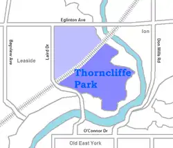
It is bounded on the east by the Don River, on the west by Millwood Road, on the north by Wicksteed Avenue and Research Road, and on the northwest by a railway track between Millwood and Wicksteed. The official community planning area named Thorncliffe Park includes the neighbourhood to the north of the railway tracks, east of Laird Avenue, south of Eglinton Avenue, and west of the Don River.
Demographics
In 2001, immigrants constituted 66% of the population of the Community Planning Area, and recent immigrants constituted 87%. Twenty-eight per cent of the residents spoke a language other than English or French at home, with the most frequent being Urdu and Gujarati.[9] In Toronto as a whole, immigrants constituted 49% of the population, and recent immigrants 11%; 19% spoke a language other than English or French at home.[10] Median household income in 2001 was $38,404 Cdn.; the median income in the entire city was $45,251. Twelve per cent of the families in the Community Planning Area were officially classified as having low household incomes, while 5% of the families throughout Toronto were so classified.[11][12]
A Toronto newspaper reported in 2004 that the neighbourhood had a low crime rate.[13]
Infrastructure
Education
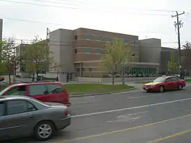
Schools operated by the Toronto District School Board in Thorncliffe Park include Thorncliffe Park Public School, Fraser Mustard Early Learning Academy, Valley Park Middle School, and Marc Garneau Collegiate Institute.
Notable people
- Michael Bliss, historian, author and Officer of the Order of Canada.[15]
- William Dennison, former Mayor of Toronto[16][17]
- Alan Redway, former Mayor of East York, and former Member of Parliament for Don Valley East and York East.[18]
See also
References
- Pitfield, Jane (2000). "13: The Origins of Street Names". Leaside. Natural Heritage Books, A Member of The Dundurn Group. ISBN 978-1-55002-875-1.
- Pitfield, Jane (2000). "18: Selected Highlights of Leaside Council Meetings". Leaside. Natural Heritage Books, A Member of The Dundurn Group. ISBN 978-1-55002-875-1.
- Bradburn, Jamie. "Historicist: The Battle of the Belles". Retrieved January 20, 2022.
- Pitfield, Jane (2000). "18: Selected Highlights of Leaside Council Meetings". Leaside. Natural Heritage Books, A Member of The Dundurn Group. ISBN 978-1-55002-875-1.
- Pitfield, Jane (2000). "18: Selected Highlights of Leaside Council Meetings". Leaside. Natural Heritage Books, A Member of The Dundurn Group. ISBN 978-1-55002-875-1.
- Pitfield, Jane (2000). "Appendix B: Leaside Town Councils 1913-1967". Leaside. Natural Heritage Books, A Member of The Dundurn Group. ISBN 978-1-55002-875-1.
- "Renaming of a portion of Thorncliffe Park Drive west of Beth Nealson Drive" (PDF). City of Toronto. April 15, 2018. Retrieved January 23, 2022.
- "Request to Rename a Portion of William Morgan Drive to Patriarch Bartholomew Way". City of Toronto. June 24, 1998. Retrieved January 23, 2022.
- Toronto, City of (14 July 2017). "Data, Research & Maps" (PDF). toronto.ca. Retrieved 19 April 2018.
- Toronto, City of (14 July 2017). "Data, Research & Maps" (PDF). toronto.ca. Retrieved 19 April 2018.
- Toronto, City of (14 July 2017). "Data, Research & Maps" (PDF). toronto.ca. Retrieved 19 April 2018.
- Toronto, City of (14 July 2017). "Data, Research & Maps" (PDF). toronto.ca. Retrieved 19 April 2018.
- https://www.theglobeandmail.com/servlet/story/RTGAM.20040220.wthorncliff0220/BNStory/Front/?query=
- "Charles H. Hiscott Bridge, Toronto | 1263051 | EMPORIS". Archived from the original on 2021-02-08.
- Bliss, Michael. "Our Leaside includes Thorncliffe Park". Retrieved January 20, 2022.
- "East York's Leaside Tower in Thorncliffe Park, Toronto Mayor William Dennison and his wife stand by the window". Toronto Public Library Digital Archive. Toronto Public Library. Retrieved January 20, 2022.
- "Even while relaxing at home in his 22nd-floor Leaside apartment, Toronto Mayor William Dennison has an attache case full of work beside him". Toronto Public Library Digital Archive. Toronto Public Library. Retrieved January 20, 2022.
- Pitfield, Jane (2000). Leaside. Natural Heritage Books, A Member of The Dundurn Group. p. 478 of 608. ISBN 978-1-55002-875-1.
External links
- Tales from the towers - a 10 Part series on Thorncliffe Park - Globe & Mail 2003
- A food tour of Thorncliffe Park - Toronto Star - Feb 27, 2008
- Thorncliffe statistics - from City of Toronto
Places adjacent to Thorncliffe Park | ||||||||||||||||
|---|---|---|---|---|---|---|---|---|---|---|---|---|---|---|---|---|
| ||||||||||||||||