Tanggamus Regency
Tanggamus Regency is a regency (kabupaten) of Lampung Province, Sumatra, Indonesia. It has an area of 4,654.96 km² and had a population of 534,595 at the 2010 Census[2] and 640,275 at the 2020 Census.[3] The regency seat is the town of Kota Agung Pusat. The regency was created on 21 March 1997. It lies in the southwest of the province, and surrounds Semangka Bay (Teluk Semangka) on its west, north and east coasts.
Tanggamus Regency
(Kabupaten Tanggamus) | |
|---|---|
 Coat of arms | |
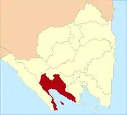 Location within Lampung | |
| Coordinates: 5.3851°S 104.6235°E | |
| Country | Indonesia |
| Province | Lampung |
| Regency seat | Kota Agung Pusat |
| Government | |
| • Regent | Samsul Hadi |
| • Vice Regent | vacant |
| Area | |
| • Total | 4,654.96 km2 (1,797.29 sq mi) |
| Population (2020 Census)[1] | |
| • Total | 640,275 |
| • Density | 140/km2 (360/sq mi) |
| Time zone | UTC+7 (IWST) |
| Area code | (+62) 722 |
| Website | tanggamus |
Administrative districts
Tanggamus Regency is divided into twenty administrative districts (kecamatan), tabulated below with their areas and their populations at the 2010 Census[4] and the 2020 Census.[5] The table also includes the locations of the district administrative centres, the number of villages (rural desa and urban kelurahan) in each district, and its post code.
| Name | Area in km2 | Population Census 2010 | Population Census 2020 | Admin centre | No. of villages | Post code |
|---|---|---|---|---|---|---|
| Wonosobo | 209.63 | 34,102 | 41,281 | Tanjung Kurung | 28 | 35685 |
| Semaka | 170.90 | 34,287 | 39,498 | Sukaraja | 22 | 35386 |
| Bandar Negeri Semuong | 98.12 | 18,213 | 17,282 | Sanggi | 11 | 35686 |
| Kota Agung | 76.93 | 39,386 | 47,147 | Kuripan | 16 | 35381 |
| Pematang Sawa | 185.29 | 15,607 | 17,832 | Way Nipah | 14 | 35382 |
| Kota Agung Timur (East Kota Agung) | 73.33 | 17,645 | 21,581 | Kagungan | 12 | 35383 |
| Kota Agung Barat (West Kota Agung) | 101.30 | 20,749 | 22,839 | Negara Batin | 16 | 35384 |
| Pulau Panggung (Panggung "Island") | 437.21 | 31,906 | 40,310 | Tekad | 21 | 35678 |
| Ulu Belu | 323.08 | 38,718 | 43,803 | Ngarip | 16 | 35387 |
| Air Naningen | 186.35 | 27,051 | 31,237 | Air Naningen | 10 | 35679 |
| Talang Padang | 45.13 | 43,029 | 53,297 | Talang Padang | 20 | 35377 |
| Sumberejo | 56.77 | 31,146 | 36,056 | Sumberejo | 13 | 35374 |
| Gisting | 32.53 | 36,006 | 43,049 | Kuta Dalom | 9 | 35378 |
| Gunung Alip | 25.68 | 17,263 | 22,151 | Banjar Negeri | 12 | 35379 |
| Pugung | 232.40 | 51,832 | 66,185 | Rantau Tijang | 27 | 35675 |
| Bulok | 51.68 | 19,532 | 24,139 | Sukamara | 10 | 35682 |
| Cukuh Balak (a) | 133.76 | 21,087 | 24,846 | Putih Doh | 20 | 35683 |
| Kelumbayan (b) | 121.09 | 10,746 | 12,236 | Napal | 8 | 35388 |
| Limau (c) | 240.61 | 17,032 | 21,665 | Kuripan | 11 | 35613 |
| Kelumbayan Barat (West Kelumbayan) | 53.67 | 11,276 | 13,841 | Sidoharjo | 6 | 35389 |
| Totals | 4,654.96 | 534,595 | 640,275 | Kota Agung Pusat | 302 |
Notes: (a) includes the substantial island of Pulau Tabuan in the southern entrance to Semangka Bay, and three small offshore islands (Pulau Batucentigi, Pulau Batuputih and Pulau Karangputih).
(b) includes 25 small offshore islands. (c) includes the small offshore island of Pulau Batukerbau.
History
In the winter of 2009/2010, the regency suffered from flooding, which saw some 80 percent of the forest in Tanggamus severely damaged. Landslides occurred in the district of Semaka and the flooding drowned several elephants including one within the protected Bukit Barisan Selatan National Park and another at the Way Kerap Dam in Tanggamus.[6]
Tourist attractions
- Kiluan Bay
- Gigi Hiu Beach
- Tanggamus Mountain
- Sawmiil Beach
- Way Lalaan Waterfall
- Jarum Lebuay Waterfall
- Batutegi Dam
- Lembah Pelangi Waterfall
References
- Badan Pusat Statistik, Jakarta, 2021.
- Biro Pusat Statistik, Jakarta, 2011.
- Badan Pusat Statistik, Jakarta, 2021.
- Biro Pusat Statistik, Jakarta, 2011.
- Badan Pusat Statistik, Jakarta, 2021.
- "Elephant dies, swept away by Tanggamus floods". Jakarta Post. 4 March 2010. Retrieved 22 February 2011.
Regencies and cities of Lampung | ||
|---|---|---|
Capital: Bandar Lampung | ||
| Regencies | ||
| Cities | ||