Tailai County
Tailai County (simplified Chinese: 泰来县; traditional Chinese: 泰來縣; pinyin: Tàilái Xiàn) is a county in the west of Heilongjiang province, People's Republic of China, bordering Inner Mongolia to the west and Jilin province to the south. It is the southernmost county-level division of the prefecture-level city of Qiqihar.
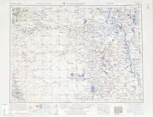
Map including Tailai (labeled as T'ai-lai (walled) 泰來) (AMS, 1956)
Tailai County
泰来县 T'ai-lai | |
|---|---|
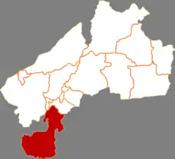 Tailai in Qiqihar | |
.png.webp) Qiqihar in Heilongjiang | |
| Coordinates: 46°23′38″N 123°25′01″E | |
| Country | People's Republic of China |
| Province | Heilongjiang |
| Prefecture-level city | Qiqihar |
| Area | |
| • Total | 4,061 km2 (1,568 sq mi) |
| Population (2010) | |
| • Total | 302,027 |
| • Density | 74/km2 (190/sq mi) |
| Time zone | UTC+8 (China Standard) |
Administrative divisions
Tailai County is divided into 7 towns, 1 ethnic town and 2 ethnic townships.[1]
- 7 towns
- Tailai (泰来镇), Pingyang (平洋镇), Tangchi (汤池镇), Tazicheng (塔子城镇), Daxing (大兴镇), Heping (和平镇), Keli (克利镇)
- 1 ethnic town
- Jiangqiao Mongol (江桥蒙古族镇)
- 2 ethnic townships
- Shengli Mongol (胜利蒙古族乡), Ningjiang Mongol (宁姜蒙古族乡)
Demographics
The population of the district was 322,562 in 1999.[2]
References
- "国家统计局 2019" (in Chinese). National Bureau of Statistics of the People's Republic of China. Retrieved 2021-12-07.
- (in English) National Population Statistics Materials by County and City - 1999 Period, in China County & City Population 1999, Harvard China Historical GIS
This article is issued from Wikipedia. The text is licensed under Creative Commons - Attribution - Sharealike. Additional terms may apply for the media files.