Sylhet District
Sylhet (Bengali: সিলেট), located in north-east Bangladesh, is the divisional capital and one of the four districts in the Sylhet Division.
Sylhet
সিলেট | |
|---|---|
| Sylhet District | |
  .JPG.webp)  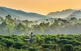 | |
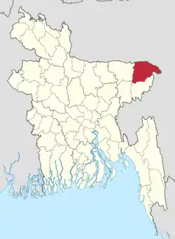 Location of Sylhet District in Bangladesh | |
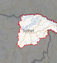 Expandable map of Sylhet District | |
| Coordinates: 24°53′N 91°52′E | |
| Country | |
| Division | Sylhet Division |
| Established | 1782 |
| Government | |
| • Deputy Commissioner | M. Kazi Emdadul Islam[1] |
| Area | |
| • Total | 3,452.07 km2 (1,332.85 sq mi) |
| Population (2011 census) | |
| • Total | 3,434,188 |
| • Density | 990/km2 (2,600/sq mi) |
| Demonym(s) | Sylheti, Siloti |
| Literacy rate | |
| • Total | 66% |
| Time zone | UTC+06:00 (BST) |
| Postal code | 3100 |
| HDI (2018) | 0.596[3] medium · 11th of 21 |
| Website | sylhet |
History
Sylhet district was established on 3 January 1782, and until 1878 it was part of Bengal province. In that year, Sylhet was included in the newly created Assam Province, and it remained as part of Assam up to 1947 (except during the brief break-up of Bengal province in 1905–11). Sylhet district was divided into five subdivisions and the current Sylhet District was known as the North Sylhet subdivision. In 1947, Sylhet became a part of East Pakistan as a result of a referendum (except 3½ thanas of Karimganj subdivision) as part of Chittagong Division.[4] It was subdivided into four districts in 1983–84 with the current Sylhet District being known as North Sylhet. It became a part of Sylhet Division after its formation in 1995. Sylhet has played a vital role in the Bangladeshi economy. Several of Bangladesh's finance ministers have been Members of Parliament from the city of Sylhet.[4]
Demographics
According to the 2011 Bangladesh census, Sylhet District had a population of 3,434,188, of which 1,726,965 were males and 1,707,223 females. Rural population was 2,680,639 (78.06%) while the urban population was 753,549 (21.94%). Sylhet district had a literacy rate of 51.18% for the population 7 years and above: 53.48% for males and 48.87% for females.[5]
Muslims make up 85.62% of the population and Christian 6.01% while Hindus are 7.23% of the population. Ethnic population is 12,781, mainly Khasi.[5]
Notable people
- Shah Jalal, Sufi saint and mystic.
- Shah Paran, Sufi saint.
- Shah Abdul Karim, Baul folk singer, composer.
- Swami Nikhilananda, Ramakrishna Math and Mission Order monk and Founder-Minister, Ramakrishna-Vivekananda Center, New York City 1933-1973
- Swami Gambhirananda, Ramakrish Math and Mission Order monk and President of the Order 1985-1988
- Nurul Islam Nahid, Former Education Minister of Bangladesh
- Govinda Chandra Dev (1 February 1907 – 26 March 1971), known as G. C. Dev, was a professor of philosophy at the University of Dhaka. He was assassinated at the onset of Bangladesh Liberation War of 1971 by the Pakistan Army.
- Abdul Malik (physician), National Professor, Brigadier (rtd.), Cardiologist, Founder and President of National Heart Foundation of Bangladesh.
- Rushanara Ali, first Bangladeshi to be elected as an MP for the British parliament.
- Ajmal Masroor, television presenter, politician and imam, Parliamentary candidate for a UK Parliament constituency.
- Lutfur Rahman (politician), the first elected mayor of the London Borough of Tower Hamlets council.
- Mukhlesur Rahman Chowdhury, former minister and adviser to the president of Bangladesh.
- Humayun Rashid Choudhury, diplomat, UN General Assembly President, Awami League leader and former speaker of National parliament.
- Dilwar Khan, poet.
- Salman Shah, film actor, model.
- Shuvro Dev, playback singer.
- Syed Ahmed (businessman), businessman, British TV personality.
- Badar Uddin Ahmed Kamran, Mayor of Sylhet since 2003, AL.
References
- pmis.mopa.gov.bd/pmis/Forms/dclist.php
- "registered through Argeweb". www.geohive.com. Archived from the original on 26 February 2014.
- "Sub-national HDI - Area Database - Global Data Lab". hdi.globaldatalab.org. Retrieved 18 March 2020.
- Ashfaq Hossain (2012). "Sylhet District". In Sirajul Islam and Ahmed A. Jamal (ed.). Banglapedia: National Encyclopedia of Bangladesh (Second ed.). Asiatic Society of Bangladesh.
- "Bangladesh Population & Housing Census 2011(Zila aeries)". Bangladesh Bureau of Statistics.
External links
![]() Media related to Sylhet District at Wikimedia Commons
Media related to Sylhet District at Wikimedia Commons
Capital: Sylhet | ||
| Upazilas | ||
| Constituencies | ||
| Attractions and sites | ||
| Rivers | ||
| Inhabited areas | ||
| Schools and colleges |
| |
| Madrasas | ||
| Universities | ||
| Transport | ||
| Organisations | ||
| History | ||
| Military | ||
| Medicine | ||
| Economy | ||
| Sports | ||