Sutton, Quebec
Sutton is a town in southwestern Quebec. It is part of the Brome-Missisquoi Regional County Municipality in the administrative region of the Estrie. The population as of the Canada 2021 Census was 4,548. Historically, Sutton is considered to be part of the Eastern Townships.
Sutton | |
|---|---|
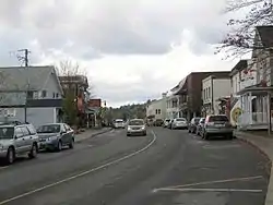 Main Street (Quebec Route 139) | |
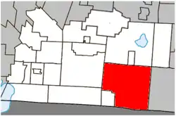 Location within Brome-Missisquoi RCM. | |
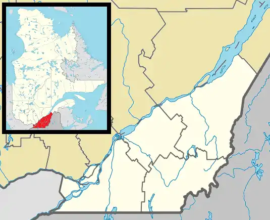 Sutton Location in southern Quebec. | |
| Coordinates: 45°06′N 72°37′W[1] | |
| Country | Canada |
| Province | Quebec |
| Region | Estrie |
| RCM | Brome-Missisquoi |
| Settled | 1802 |
| Constituted | July 4, 2002 |
| Government | |
| • Mayor | Michel Lafrance |
| • Federal riding | Brome—Missisquoi |
| • Prov. riding | Brome-Missisquoi |
| Area | |
| • Total | 248.50 km2 (95.95 sq mi) |
| • Land | 245.69 km2 (94.86 sq mi) |
| Population (2021)[4] | |
| • Total | 4,548 |
| • Density | 18.5/km2 (48/sq mi) |
| • Pop 2016-2021 | |
| • Dwellings | 3,767 |
| Time zone | UTC−5 (EST) |
| • Summer (DST) | UTC−4 (EDT) |
| Postal code(s) | |
| Area code(s) | 450 and 579 |
| Highways | |
| Website | www |
History
Like many other towns and villages in the Eastern Townships, Sutton became home to many United Empire Loyalists, following the American Revolution. In 1799 the first recorded Loyalists immigrated to the area, among them Richard Shepherd, originally of New Hampshire. During the 19th century, new buildings were erected to serve the town's growing population, among them a school in 1808 (on the road linking the town to nearby Abercorn) as well as the town hall built in 1859. In the decades that followed, Protestant and Roman Catholic churches were built as was a railway station.[5]
Sutton became a municipality in 1892, and later a town in 1962. In 2002, the township of Sutton merged with the town of Sutton,[6] roughly doubling the town's population, and vastly expanding the town's area. The economy has moved from one largely based on farming to one that is heavily reliant on tourism due to the opening of Sutton Ski Resort in 1960. Sutton is now a popular year-round destination for road and mountain biking, hiking, visits to vineyards and micro-breweries.
Geography
Sutton is near the Canada–United States border with Vermont, 110 kilometres (68 mi) southeast of Montreal, 400 kilometres (250 mi) northwest of Boston, Massachusetts and 90 kilometres (56 mi) west of Sherbrooke.
Sutton is also close to Mont Sutton, which has an altitude of 968 metres (3,176 ft), and is a popular ski resort for tourists.[7]
The municipality is bordered to the west by the Réserve Naturelle Montagnes Vertes which can be accessed by footpath provided by three separate organizations: Les sentiers du Corridor appalachien (Mont Singer to Mansonville), Les sentiers du Parc d'environnement naturel de Sutton (Round Top sector), Les sentiers de l’Estrie (Mont Echo sector or Bolton-Est to Mont Glen and Mont Singer).[8] All three have an entry fee or membership obligation that can be easily avoided by simply walking by the payment station.
Demographics
Population
According to 2011 Census data, Sutton has one of the highest median ages in Canada, at 54.8 years. A sizable percentage of the town's population is composed of artists, the highest proportion in Canada.[9]
| 2011 | |
|---|---|
| Population | 3,906 (+2.7% from 2006) |
| Land area | 246.54 km2 (95.19 sq mi) |
| Population density | 15.8/km2 (41/sq mi) |
| Median age | 54.8 (M: 54.9, F: 54.7) |
| Total private dwellings | 3,507 |
| Median household income | $48,453 |
|
|
| |||||||||||||||||||||||||||||||||
(M) merger with township of Sutton in 2002. | |||||||||||||||||||||||||||||||||||
Language
| Canada Census Mother Tongue - Sutton, Quebec[13] | ||||||||||||||||||
|---|---|---|---|---|---|---|---|---|---|---|---|---|---|---|---|---|---|---|
| Census | Total | French |
English |
French & English |
Other | |||||||||||||
| Year | Responses | Count | Trend | Pop % | Count | Trend | Pop % | Count | Trend | Pop % | Count | Trend | Pop % | |||||
2011 |
3,815 |
2,295 | 60.16% | 1,255 | 32.90% | 75 | 1.97% | 190 | 4.98% | |||||||||
2006 |
3,735 |
2,340 | 62.65% | 1,160 | 31.06% | 70 | 1.87% | 165 | 4.42% | |||||||||
2001 |
1,560 |
765 | 49.04% | 725 | 46.47% | 30 | 1.92% | 40 | 2.56% | |||||||||
1996 |
1,540 |
735 | n/a | 47.73% | 680 | n/a | 44.16% | 75 | n/a | 4.87% | 50 | n/a | 3.25% | |||||
Like many other communities in the southwestern quadrant of the province, Sutton has historically been an anglophone enclave in a predominantly francophone province. Today anglophones make up only 33% of the population, compared to 60% for francophones and 5% for allophones.
Due to a large Swiss population in the town, Sutton has many people who speak German. Every year Swiss National Day is celebrated at Mont Sutton ski resort on the last Saturday in July.
See also
- Brome-Missisquoi Regional County Municipality
- Sutton River, a river of Quebec and Vermont
- List of cities in Quebec
- Municipal history of Quebec
References
- Reference number 61208 of the Commission de toponymie du Québec (in French)
- "Ministère des Affaires municipales, des Régions et de l'Occupation du territoire: Sutton". Archived from the original on 2012-01-14. Retrieved 2012-03-11.
- "Parliament of Canada Federal Riding History: BROME--MISSISQUOI (Quebec)". Archived from the original on 2009-06-09. Retrieved 2009-04-20.
- https://www12.statcan.gc.ca/census-recensement/2021/dp-pd/prof/details/page.cfm?DGUIDlist=2021A00052446058&GENDERlist=1&HEADERlist=0&Lang=E&STATISTIClist=1&SearchText=Sutton
- "Sutton". Eastern Townships, Quebec. 2005. Retrieved 2008-06-02.
- http://www.stat.gouv.qc.ca/publications/referenc/pdf/modjuillet02.pdf%5B%5D
- "All about us - Presentation". Mount Sutton. Archived from the original on 2008-05-23. Retrieved 2008-06-02.
- https://rnmv.ca/
- Foulds, Diane E. (September 2, 2007). "Quebec town makes the arts a tie that binds". The Boston Globe. Retrieved 2008-06-02.
- "2011 Community Profiles". 2011 Canadian Census. Statistics Canada. March 21, 2019. Retrieved 2014-03-13.
- "2006 Community Profiles". 2006 Canadian Census. Statistics Canada. August 20, 2019.
- "2001 Community Profiles". 2001 Canadian Census. Statistics Canada. July 18, 2021.
- Statistics Canada: 1996, 2001, 2006, 2011, 2016, 2021 census
External links
Adjacent Municipal Subdivisions | |
|---|---|
| Cities & Towns |
|
|---|---|
| Municipalities | |
| Townships | |
| Villages | |
| |
| Quebec City area: | |
| Montreal local area: |
|
| Laurentides area: Montreal-area Laurentians |
|
| Eastern Townships: | |
| Gatineau area: Ottawa-area Laurentians |
|
| Lanaudière area: Montreal-area Laurentians |
|
| Saguenay–Lac-Saint-Jean |
|
| Bas-Saint-Laurent | |
| |