Stonehurst East, New Jersey
Stonehurst East is an unincorporated community located within the western section of Freehold Township in Monmouth County, New Jersey, United States. The area is mostly made up of a housing development bordered by U.S. Route 9, Schanck Road, Stillwells Corner Road, and County Route 524.[2] The area was farmland until it was developed into homes in the late 1960s.[3][4]
Stonehurst East, New Jersey | |
|---|---|
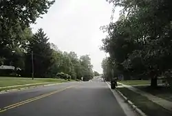 Along Schanck Road | |
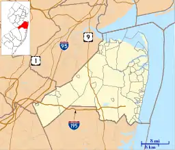 Stonehurst East Location of Stonehurst East in Monmouth County Inset: Location of county within the state of New Jersey  Stonehurst East Stonehurst East (New Jersey)  Stonehurst East Stonehurst East (the United States) | |
| Coordinates: 40°13′48″N 74°17′14″W | |
| Country | |
| State | |
| County | Monmouth |
| Township | Freehold |
| Elevation | 125 ft (38 m) |
| Time zone | UTC-5 (Eastern (EST)) |
| • Summer (DST) | UTC-4 (EDT) |
| GNIS feature ID | 883198[1] |
References
- "Stonehurst East". Geographic Names Information System. United States Geological Survey.
- Google (October 4, 2015). "Stonehurst East, New Jersey" (Map). Google Maps. Google. Retrieved October 4, 2015.
- "Aerial view of Stonehurst East, 1963". Historic Aerials. 1963. Retrieved October 4, 2015.
{{cite web}}: Check|url=value (help) - "Aerial view of Stonehurst East, 1970". Historic Aerials. 1970. Retrieved October 4, 2015.
{{cite web}}: Check|url=value (help)
This article is issued from Wikipedia. The text is licensed under Creative Commons - Attribution - Sharealike. Additional terms may apply for the media files.