Stone routes
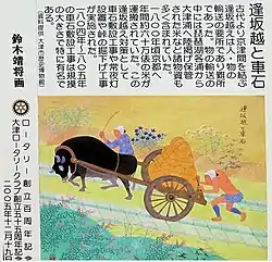
The Stone routes (Japanese: 車道 = Kuruma-michi), also called the Vehicle stones (Japanese: 車石 = Kuruma-ishi), were a pair of stone-paved "rails" that were placed on the side of the three main highways leading to Kyoto, Japan, so that the oxcarts could ride on them during the 18th–19th century latter half of the Edo period.
Overview
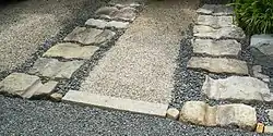
Kyoto, the traditional capital of Japan, was, unlike the other large Japanese cities such as Tokyo and Osaka, in the interior of the land, and, therefore, was a place difficult to cart materials in. During the 18th–19th century latter half of the Edo period, the stone routes were placed on the side of the three main highways leading to Kyoto, so that bullock carts could ride on them, especially useful over the mountain passes when it rained and caused muddy conditions. The three highways were: the Tokaido, Takeda-Kaido (竹田街道) and Toba-Kaido (鳥羽街道).[1][2]
A stone route was typically 2.7 meters (9 shaku) wide, with the two rows of stones of 30 cm x 60 cm × 25 cm size on both sides and a 90 cm (3 shaku) wide center for the bulls to walk. When the railways were introduced in the 19th century, the vehicle stone were dismantled and used for other purposes and, therefore, they came to mean the stone routes.
In 2013, the Association of Vehicle Stones and Stone Routes Research (Japanese: 車石・車道研究会) was established.[3]
See also
- Transport in Japan during the Edo period (ja:日本の交通#江戸時代)