Sterling, Georgia
Sterling is an unincorporated community and census-designated place (CDP) in Glynn County, Georgia, United States, located on U.S. Route 341. Sterling consists of several small churches and general stores. It is included in the Brunswick, Georgia statistical area. Its zip code is 31525.
Sterling, Georgia | |
|---|---|
 Sterling  Sterling | |
| Coordinates: 31.272°N 81.562°W | |
| Country | United States |
| State | Georgia |
| County | Glynn |
| Area | |
| • Total | 4.33 sq mi (11.21 km2) |
| • Land | 4.31 sq mi (11.15 km2) |
| • Water | 0.02 sq mi (0.06 km2) |
| Elevation | 3 ft (0.9 m) |
| Population (2020) | |
| • Total | 2,534 |
| • Density | 588.48/sq mi (227.21/km2) |
| Time zone | UTC-5 (Eastern (EST)) |
| • Summer (DST) | UTC-4 (EDT) |
| ZIP Code | 31525 |
| Area code(s) | 912 |
| FIPS code | 13-73452 |
It was first listed as a CDP in the 2020 census with a population of 2,534.[2]
Sterling formerly had a station on the Macon and Brunswick Railroad.[3]
Demographics
| Historical population | |||
|---|---|---|---|
| Census | Pop. | %± | |
| 2020 | 2,534 | — | |
| U.S. Decennial Census[4] 2020[5] | |||
2020 census
| Race / Ethnicity | Pop 2020[5] | % 2020 |
|---|---|---|
| White alone (NH) | 1,402 | 55.33% |
| Black or African American alone (NH) | 485 | 19.14% |
| Native American or Alaska Native alone (NH) | 15 | 0.59% |
| Asian alone (NH) | 54 | 2.13% |
| Pacific Islander alone (NH) | 3 | 0.12% |
| Some Other Race alone (NH) | 11 | 0.43% |
| Mixed Race/Multi-Racial (NH) | 119 | 4.70% |
| Hispanic or Latino (any race) | 445 | 17.56% |
| Total | 2,534 | 100.00% |
Note: the US Census treats Hispanic/Latino as an ethnic category. This table excludes Latinos from the racial categories and assigns them to a separate category. Hispanics/Latinos can be of any race.
Education
Glynn County's public schools are operated by Glynn County School System.
Zoned schools include:
- Sterling Elementary School (SES)[6]
- Jane Macon Middle School (JMS)[7]
- Brunswick High School (BHS)[8]
References
- "2020 U.S. Gazetteer Files". United States Census Bureau. Retrieved December 18, 2021.
- "Sterling CDP, Georgia". United States Census Bureau. Retrieved April 7, 2022.
- Legare, John Girardeau (2012). The Darien Journal of John Girardeau Legare, Ricegrower. University of Georgia Press. p. 113. ISBN 9780820343105.
- "Decennial Census of Population and Housing by Decades". US Census Bureau.
- "P2 HISPANIC OR LATINO, AND NOT HISPANIC OR LATINO BY RACE – 2020: DEC Redistricting Data (PL 94-171) – Sterling CDP, Georgia". United States Census Bureau.
- "Elementary School Zones Map." Glynn County School System. Retrieved on March 13, 2019.
- "Middle School Zones Map." Glynn County School System. Retrieved on March 13, 2019. Detail of Jane Macon MS Zone Map
- "High School Zones Map." Glynn County School System. Retrieved on March 13, 2019.
Municipalities and communities of Glynn County, Georgia, United States | ||
|---|---|---|
| City | 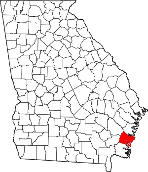 Map of Georgia highlighting Glynn County | |
| CDPs | ||
| Other unincorporated communities | ||
| Ghost towns | ||
| ||
This article is issued from Wikipedia. The text is licensed under Creative Commons - Attribution - Sharealike. Additional terms may apply for the media files.