Spiess Rocks
Spiess Rocks (54°25′S 3°29′E) is a group of submerged rocks which extend up to 0.4 nautical miles (0.7 km) northeast of Cape Lollo on the island of Bouvetøya. First charted in December 1927 by a Norwegian expedition under Captain Harald Horntvedt. Named by the Norwegians for Captain Fritz A. Spiess, leader of the German expedition which visited Bouvetoya on board the "Meteor" in 1926. [1] [2]
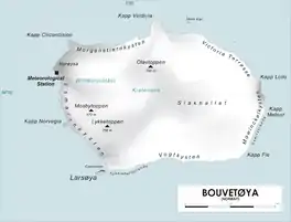
Map of Bouvetøya
References
- "Norvegia-ekspedisjonene". Store norske leksikon. Retrieved October 1, 2016.
- "Some Early German Contributions to Oceanography". hydro-international.com. Retrieved October 1, 2016.
Other sources
- Simpson-Housley, Paul (2002) Antarctica: Exploration, Perception and Metaphor (Routledge) ISBN 9781134891214
![]() This article incorporates public domain material from the United States Geological Survey document: "Spiess Rocks". (content from the Geographic Names Information System)
This article incorporates public domain material from the United States Geological Survey document: "Spiess Rocks". (content from the Geographic Names Information System)
This article is issued from Wikipedia. The text is licensed under Creative Commons - Attribution - Sharealike. Additional terms may apply for the media files.