Southland District
Southland District is a New Zealand territorial authority that covers the south of the South Island as well as Stewart Island/Rakiura.
Southland District | |
|---|---|
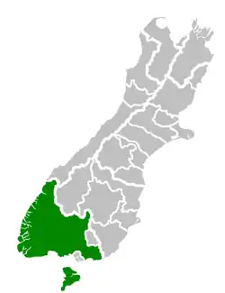 Location of the Southland District within the South Island | |
| Country | New Zealand |
| Region | Southland Region |
| Communities |
|
| Wards |
|
| Formed | 1989 |
| Seat | Invercargill |
| Government | |
| • Mayor | Gary Tong |
| • Territorial authority | Southland District Council |
| Area | |
| • Land | 29,574.53 km2 (11,418.79 sq mi) |
| Population (June 2021)[2] | |
| • Total | 32,700 |
| Time zone | UTC+12 (NZST) |
| • Summer (DST) | UTC+13 (NZDT) |
| Postcode(s) | |
| Website | Southland District Council |
History
Southland District was formed through the 1989 local government reforms.[3] Four local authorities were amalgamated at that time: Wallace County, Winton Borough, Stewart Island County and most of Southland County. John Casey, who was first elected onto Southland County Council in 1977, oversaw the amalgamation and was elected Southland District's first mayor in 1989.[4]
Geography
_-_Lake_Manapouri.jpg.webp)
Southland District covers the majority of the land area of Southland Region, although the region also covers Gore District, Invercargill City and adjacent territorial waters. It has a land area of 29,574.53 km2, excluding inland waters such as Lake Te Anau, Lake Manapouri, and Lake Hauroko.
Southland District contains the islands south of Foveaux Strait:
The seat of the District Council is Invercargill, which, however, is not part of Southland District, but a territorial authority in its own right.
Two of New Zealand's largest national parks are within the boundaries of Southland District: Fiordland National Park, and Rakiura National Park (which covers most of Stewart Island/Rakiura).
Demographics
Southland District covers 29,574.53 km2 (11,418.79 sq mi)[1] and had an estimated population of 32,700 as of June 2021,[2] with a population density of 1.1 people per km2.
| Year | Pop. | ±% p.a. |
|---|---|---|
| 2006 | 28,437 | — |
| 2013 | 29,613 | +0.58% |
| 2018 | 30,864 | +0.83% |
| Source: [5] | ||
Southland District had a population of 30,864 at the 2018 New Zealand census, an increase of 1,251 people (4.2%) since the 2013 census, and an increase of 2,427 people (8.5%) since the 2006 census. There were 11,982 households. There were 16,029 males and 14,835 females, giving a sex ratio of 1.08 males per female. The median age was 39.1 years (compared with 37.4 years nationally), with 6,534 people (21.2%) aged under 15 years, 5,262 (17.0%) aged 15 to 29, 14,436 (46.8%) aged 30 to 64, and 4,635 (15.0%) aged 65 or older.
Ethnicities were 88.1% European/Pākehā, 11.1% Māori, 1.1% Pacific peoples, 6.2% Asian, and 2.3% other ethnicities. People may identify with more than one ethnicity.
The percentage of people born overseas was 13.6, compared with 27.1% nationally.
Although some people objected to giving their religion, 51.7% had no religion, 38.4% were Christian, 0.5% were Hindu, 0.2% were Muslim, 0.3% were Buddhist and 1.7% had other religions.
Of those at least 15 years old, 3,363 (13.8%) people had a bachelor or higher degree, and 5,739 (23.6%) people had no formal qualifications. The median income was $36,300, compared with $31,800 nationally. 3,732 people (15.3%) earned over $70,000 compared to 17.2% nationally. The employment status of those at least 15 was that 13,956 (57.4%) people were employed full-time, 4,053 (16.7%) were part-time, and 519 (2.1%) were unemployed.[5]
| Name | Area (km2) | Population | Density (per km2) | Households | Median age | Median income |
|---|---|---|---|---|---|---|
| Mararoa-Waimea Ward | 17,420.86 | 7,953 | 0.46 | 3,081 | 38.8 years | $36,800 |
| Waiau-Aparima Ward | 6,381.17 | 7,908 | 1.24 | 3,153 | 40.6 years | $31,900 |
| Winton-Wallacetown Ward | 1,826.23 | 9,117 | 4.99 | 3,468 | 39.1 years | $38,600 |
| Waihopai-Toetoes Ward | 2,176.35 | 5,481 | 2.52 | 2,055 | 37.2 years | $37,900 |
| Stewart Island/Rakiura Ward | 1,747.74 | 408 | 0.22 | 222 | 49.3 years | $33,500 |
| New Zealand | 37.4 years | $31,800 |
Urban areas and settlements
The Southland District has three towns with a population over 1,000. Together they are home to 21.6% of the district's population.[2]
| Urban area | Population
(June 2021)[2] |
% of district |
|---|---|---|
| Te Anau | 2,930 | 9.0% |
| Winton | 2,450 | 7.5% |
| Riverton | 1,690 | 5.2% |
Other settlements and localities in the district include:
Mararoa Waimea Ward
|
|
Waiau Aparima Ward
Waihopai Toetoes Ward
|
|
Winton Wallacetown Ward
|
|
Stewart Island-Rakiura Ward
- Oban
- Port Pegasus (uninhabited)
- Port William (uninhabited)
Mayor
The current district mayor is Gary Tong. He has held this position since 2013.
Council
The district council is made up of twelve elected members, from various ward areas, and like any other local authority is elected every three years.
Sister cities
Current sister city
Former sister city
Southland District was a sister city to Wyong Shire in New South Wales, Australia until 2010.[7]
References
- "ArcGIS Web Application". statsnz.maps.arcgis.com. Retrieved 5 February 2022.
- "Population estimate tables - NZ.Stat". Statistics New Zealand. Retrieved 22 October 2021.
- "Role of Council". Southland District Council. Retrieved 24 April 2015.
- Veltkamp Smith, Pat (29 June 2011). "Life of community works". The Southland Times. Retrieved 25 April 2015.
- "Statistical area 1 dataset for 2018 Census". Statistics New Zealand. March 2020. Southland District (073). 2018 Census place summary: Southland District
- Cinque Terre Sister City agreement to be signed on Thursday (Southland District Council press release 24 March 2009)
- Wyong Shire Council (14 January 2010). "Councillors aren't flippant when it comes to expenses". Retrieved 21 May 2012.