South Lincoln, Vermont
South Lincoln is a census-designated place (CDP) within the town of Lincoln, Addison County, Vermont, United States. It was first listed as a CDP prior to the 2020 census.[2]
South Lincoln, Vermont | |
|---|---|
 South Lincoln  South Lincoln | |
| Coordinates: 44°4′16″N 72°58′22″W | |
| Country | United States |
| State | Vermont |
| County | Addison |
| Town | Lincoln |
| Area | |
| • Total | 2.41 sq mi (6.23 km2) |
| • Land | 2.37 sq mi (6.15 km2) |
| • Water | 0.03 sq mi (0.08 km2) |
| Elevation | 1,313 ft (400 m) |
| Time zone | UTC-5 (Eastern (EST)) |
| • Summer (DST) | UTC-4 (EDT) |
| ZIP Code | 05443 (Bristol) |
| Area code(s) | 802 |
| FIPS code | 50-67150 |
| GNIS feature ID | 2805708[2] |
It is in eastern Addison County, in the south part of the town of Lincoln, in the valley of the New Haven River, a north-flowing tributary of Otter Creek and part of the Lake Champlain watershed. It is bordered to the south and east by the Green Mountain National Forest. South Lincoln Road leads north (downriver) 3 miles (5 km) to Lincoln, and Ripton Road leads southwest 9 miles (14 km) to Ripton.
References
- "2020 U.S. Gazetteer Files – Vermont". United States Census Bureau. Retrieved October 1, 2021.
- "South Lincoln Census Designated Place". Geographic Names Information System. United States Geological Survey.
Municipalities and communities of Addison County, Vermont, United States | ||
|---|---|---|
| City | 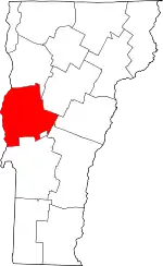 Map of Vermont highlighting Addison County | |
| Towns | ||
| CDPs | ||
| Other communities | ||
| ||
This article is issued from Wikipedia. The text is licensed under Creative Commons - Attribution - Sharealike. Additional terms may apply for the media files.