South Dakota Highway 50
South Dakota Highway 50 (SD 50) is a state route serving south central and southeast South Dakota. The current alignment begins at the junction of South Dakota Highway 34 at "Lee's Corner" east of Fort Thompson, and ends at the Iowa border near Richland, where it continues as Iowa Highway 3. It is about 212 miles (341 km) in length.
 | ||||
|---|---|---|---|---|
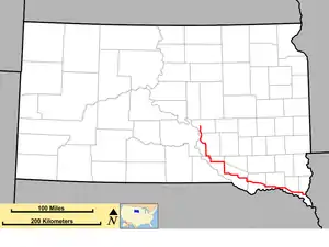 Route of SD 50 (in red) | ||||
| Route information | ||||
| Maintained by SDDOT | ||||
| Length | 212.421 mi[1] (341.858 km) | |||
| Existed | 1926–present | |||
| Tourist routes | ||||
| Major junctions | ||||
| West end | ||||
| East end | ||||
| Location | ||||
| Country | United States | |||
| State | South Dakota | |||
| Counties | Buffalo, Brule, Charles Mix, Bon Homme, Yankton, Clay, Union | |||
| Highway system | ||||
| ||||
| ||||
History
SD 50 was designated on the route known as the Sunshine Highway. When it was formed in the 1920s, it traveled the entire length of southern South Dakota, from the Wyoming state line west of Edgemont, to the Iowa state line at Sioux City.
When U.S. Route 18 (US 18) was designated in the late 1920s, it replaced the SD 50 designation from the Wyoming state line at Ravinia (east of Lake Andes). SD 50 continued in southeast South Dakota.
Around 1940, SD 50 was extended northwest of its former terminus. It assumed a portion of alignment of SD 45 through Geddes, and SD 47 through Academy; the northern terminus became US 16 near Pukwana.
Around 1950, the eastern terminus was rerouted. At US 77 (with which it had previously shared a concurrency to Sioux City), SD 50 was extended east to the Iowa state line.
In 1975, the northwestern terminus was again extended. It was routed west to Chamberlain, then assumed a segment of SD 47 (which had been realigned west) to its new northern terminus at SD 34 east of Fort Thompson.[2]
Major intersections
| County | Location | mi[1] | km | Destinations | Notes |
|---|---|---|---|---|---|
| Buffalo | Crow Creek | 0.000 | 0.000 | Western terminus | |
| Brule | Chamberlain | 20.145 | 32.420 | Western end of BL I-90 concurrency | |
| 23.331– 23.450 | 37.548– 37.739 | Eastern terminus of BL I-90, western end of I-90 concurrency, exit 265. | |||
| Red Lake Township | 29.642– 30.237 | 47.704– 48.662 | Eastern end of I-90 concurrency, exit 272. | ||
| Charles Mix | Castalia | 61.986 | 99.757 | Western end of SD 44 concurrency | |
| 64.074 | 103.117 | ||||
| Platte | 72.070 | 115.985 | Southern terminus of SD 45 | ||
| Darlington–Clark township line | 78.999 | 127.137 | Eastern end of SD 44 concurrency | ||
| Jackson Township | 93.827 | 151.000 | |||
| Lake Andes | 102.714 | 165.302 | Western end of US 18/US 281 concurrency | ||
| Plain Center–Bryan township line | 112.611 | 181.230 | Eastern end of US 18/US 281 concurrency | ||
| Wagner | 117.904 | 189.748 | Western end of SD 46 concurrency | ||
| Lone Tree–Choteau Creek township line | 126.743 | 203.973 | Eastern end of SD 46 concurrency | ||
| Bon Homme | Northwest Bon Homme | 137.056 | 220.570 | Western end of SD 37 concurrency | |
| Southwest Bon Homme | 141.175 | 227.199 | Eastern end of SD 37 concurrency | ||
| Southeast Bon Homme | 150.725 | 242.568 | Southern terminus of SD 25 | ||
| 156.817 | 252.372 | Western end of SD 52 concurrency | |||
| Yankton | West Yankton | 161.701 | 260.233 | Eastern end of SD 52 concurrency | |
| 164.738 | 265.120 | Northern terminus of SD 153 | |||
| 165.322 | 266.060 | Western terminus of SD 314 | |||
| Yankton | 169.768 | 273.215 | Northern end of US 81 concurrency | ||
| 172.435 | 277.507 | Eastern terminus of SD 52, southern end of US 81 concurrency | |||
| Clay | Vermillion Township | 194.864 | 313.603 | Western terminus of SD 50 Bus. | |
| Vermillion | 196.882 | 316.851 | Vermillion only signed eastbound; Newcastle, NE only signed westbound | ||
| Fairview Township | 197.238 | 317.424 | Eastern terminus of SD 50 Bus. | ||
| Union | Brule Township | 202.894– 203.069 | 326.526– 326.808 | I-29 Exit 26. | |
| 209.632 | 337.370 | Northern terminus of southern segment of SD 11 | |||
| Plymouth | Richland Township | 212.421 | 341.858 | Continuation into Iowa | |
1.000 mi = 1.609 km; 1.000 km = 0.621 mi
| |||||
References
- "State Highway Log: Mitchell Region" (PDF). South Dakota Department of Transportation. January 2012. Retrieved 2013-12-23.
- "Highway Division Makes Road Numbering Changes". The Sioux Falls Argus-Leader. March 20, 1975. p. 2 (32). Retrieved March 18, 2020 – via Newspapers.com.