Somalia–Somaliland border
The Somalia–Somaliland border (Somali: Xuduuda Soomaaliya iyo Soomaaliland; Arabic: الحدود بين الصومال وصوماليلاند), is the disputed border between Somalia and the self-declared sovereign state of Somaliland.[2][3][4] It is an international border that separates two countries, while the Somali government and most other countries refer to it as the "Administrative Boundary Line". The government of Somaliland regards itself as the successor itself as the successor independent State of Somaliland, united in 1960 with the Trust Territory of Somaliland.[5]
| Somaliland-Somalia border | |
|---|---|
.jpg.webp) The border between Somalia and the Somaliland | |
| Characteristics | |
| Entities | |
| Length | 402 kilometers (250 mi) |
| History | |
| Current shape | 1929 |
| Treaties | Somaliland. Anglo-Italian Boundary Treaty.[1] |
History
Anglo-Italian Boundary Treaty era (1894 and 1960)
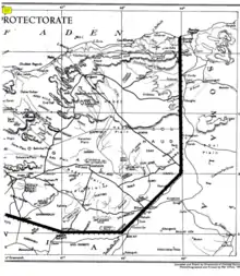
In May 1894, the border between Somaliland and Somalia was demarcated by the Anglo-Italian.[6][7][8] Officially implemented in 1929, it extends along longitude 49 (49E), from the Gulf of Aden to 9°N latitude, and then diagonally across the intersection of longitude 48 (48E) and 8N latitude. West along 8N latitude which is the beginning of the border between Somaliland and Ethiopia.[9]
The names of the villages that are close to the border:
- A1 Hills (A1 Mado)
- Bunda Ziada
- Bosaso or Bender Casim (Italian)
- Hegligab (Higle-Gab)
- Sorl Hand
- Darror
- Hauratiroh
- Marojeh
- Khumberl (E1 Gumbuhul)
- Hobat
- Dugaan
- E1 Dibr
- Galweineh
- Darado
- Wareigleh
Restoration of sovereignty (1991)
After a long war of independence with the Siad Barre regime, in 1991, Somaliland regained sovereignty from Somali Democratic Republic,[10][11][12] Which is not recognized by the Somali government.
According to the constitution voted for by the people of Somaliland, the border between Somaliland and Somalia is the border of the State of Somaliland which gained independence on May 26, 1960.[13]
dispute border
.svg.png.webp)
The Puntland state disputes the Sool and Sanaag regions, as well as parts of Togdheer.
Historical maps
Historical maps of the border from north to south in the International Map of the World.
- between Somalia Italia and State of Somaliland
- full limits
.jpg.webp)
.jpg.webp)
.jpg.webp)
.jpg.webp)
.jpg.webp)
.jpg.webp)
See also
- Somaliland
 Somaliland portal
 Somalia portal
References
- Stafford, J. H.; Collenette, C. L. (1931). "The Anglo-Italian Somaliland Boundary". The Geographical Journal. 78 (2): 102–121. doi:10.2307/1784441. JSTOR 1784441.
- https://africaoilcorp.com/site/assets/files/1267/2012_aif.pdf
- "Averting War in Northern Somalia". 27 June 2018.
- "Puntland vows to reject outcome of FGS-Somaliland talks, wants new electoral law nullified".
- Encyclopædia Britannica, The New Encyclopædia Britannica, (Encyclopædia Britannica: 2002), p.835
- https://jgs.lyellcollection.org/content/jgsleg/87/1-4/local/front-matter.pdf
- "Anglo-Italian Relations in the Middle East, 1922-1940". 13 September 0418.
- Stafford, J. H.; Collenette, C. L. (1931). "The Anglo-Italian Somaliland Boundary". The Geographical Journal. 78 (2): 102–121. doi:10.2307/1784441. JSTOR 1784441.
- "Somaliland Boundaries".
- "Somaliland: 25 years as an unrecognised state".
- "Somaliland | historical region, Africa".
- "Somaliland: 30 Years of de Facto Statehood, and No End in Sight". 7 May 2021.
- "Elections in Somaliland". africanelections.tripod.com. Retrieved 2020-06-20.