Sint-Michielsgestel (municipality)
Sint-Michielsgestel (Dutch pronunciation: [ˈsɪnt miˌxilsˈxɛstəl] (![]() listen)) is a municipality in the southern part of the Netherlands. It is named for the village of Sint-Michielsgestel located within its boundaries.
listen)) is a municipality in the southern part of the Netherlands. It is named for the village of Sint-Michielsgestel located within its boundaries.
Sint-Michielsgestel | |
|---|---|
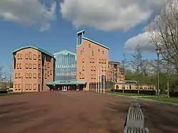 Town hall of Sint-Michielsgestel | |
 Flag Coat of arms | |
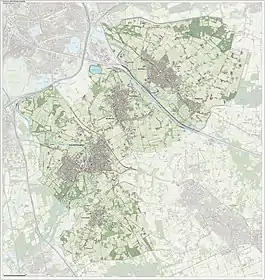
.svg.png.webp) Location in North Brabant | |
| Coordinates: 51°38′N 5°21′E | |
| Country | Netherlands |
| Province | North Brabant |
| Government | |
| • Body | Municipal council |
| • Mayor | Han Looijen (VVD) |
| Area | |
| • Total | 59.34 km2 (22.91 sq mi) |
| • Land | 58.38 km2 (22.54 sq mi) |
| • Water | 0.96 km2 (0.37 sq mi) |
| Elevation | 6 m (20 ft) |
| Population (January 2019)[4] | |
| • Total | 28,991 |
| • Density | 497/km2 (1,290/sq mi) |
| Time zone | UTC+1 (CET) |
| • Summer (DST) | UTC+2 (CEST) |
| Postcode | 5258, 5270–5275, 5290–5294 |
| Area code | 073 |
| Website | sint-michielsgestel |
Population centres
- Berlicum
- Den Dungen
- Gemonde
- Sint-Michielsgestel
Smaller townships, also part of Sint-Michielsgestel, are: Besselaar, Doornhoek, Haanwijk, Hal, Halder, De Bus, De Hogert, De Loofaart, Heikantse Hoeve, Hersend, Hezelaar, Hoek, Kerkeind, Laar, Maaskantje, Middelrode, Nijvelaar, Plein, Poeldonk, Ruimel, Tielse Hoeve, Wielsche Hoeven, Wamberg and Woud.
Contemporary Sint-Michielsgestel
The municipality consists of a number of villages and rural areas just south and south east of 's-Hertogenbosch. Most inhabitants are commuters preferring to live in these quite villages, while working elsewhere. There is little industrial activity in the villages, but the agricultural sector is certainly important.
Sint-Michielsgestel and Gemonde are in the drainage basin of the river Dommel. Den Dungen, Berlicum and Middelrode are in that of the Aa (Meuse) and the Zuid-Willemsvaart. It makes that there are very few roads connecting these two groups of settlements.
History
The current municipality Sint-Michielsgestel was created in 1996. That year the municipalities of Sint-Michielsgestel, Den Dungen (est. 1810) and Berlicum (est. 1238) were merged. The entire village of Gemonde, which had previously been part of Boxtel, Sint-Michielsgestel, Sint-Oedenrode and Schijndel, was added to the new municipality.
Local government
The municipal council of Sint-Michielsgestel consists of 21 seats, which are divided as follows after the municipal elections of March 21 2018:[5]
- Local Political Alliance (Plaatselijke Politieke Alliantie) - 7 seats
- CDA - 4 seats
- Dorpsgoed - 3 seats
- VVD - 2 seats
- De Gestelse Coalitie - 2 seats
- PvdA - 1 seat
- D66 - 1 seat
- GroenLinks - 1 seat
At the moment, the municipal board (college van burgemeester en wethouders) is formed by the Local Political Alliance, CDA and VVD.
Notable people
.jpg.webp)
- Gerrit Braks (1933–2017) a Dutch politician and agronomist
- Cas Wouters (born 1943) a Dutch sociologist who embraces figurational sociology
- Anneke van Giersbergen (born 1973) a Dutch singer, songwriter, guitarist and pianist; [6] formerly of The Gathering
Sport
- Jan van Grinsven (born 1960 in Den Dungen) a former football goalkeeper with 484 club caps
- Ronald Jansen (born 1963) a former field hockey goalkeeper, gold medallist in the 1996 and 2000 Summer Olympics
- Kees Akerboom Jr. (born 1983) a retired Dutch basketball player
- Tom van Weert (born 1990) a footballer with 230 club caps, currently playing at Volos, Greece
Gallery
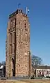 Sint-Michielsgestel, the Tower
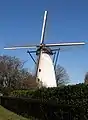 Sint-Michielsgestel, windmill: the Genenberg
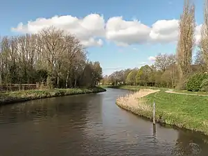 The Dommel near Sint Michielsgestel
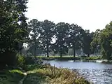 Dommel near Gemonde
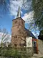 Berlicum, church
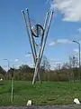 Berlicum, modern art on the street
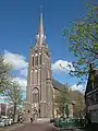 Den Dungen, church
References
- "Samenstelling College van B en W" [Members board of mayor and aldermen] (in Dutch). Gemeente Sint-Michielsgestel. Archived from the original on 6 June 2014. Retrieved 3 June 2014.
- "Kerncijfers wijken en buurten 2020" [Key figures for neighbourhoods 2020]. StatLine (in Dutch). CBS. 24 July 2020. Retrieved 19 September 2020.
- "Postcodetool for 5271GC". Actueel Hoogtebestand Nederland (in Dutch). Het Waterschapshuis. Retrieved 3 June 2014.
- "Bevolkingsontwikkeling; regio per maand" [Population growth; regions per month]. CBS Statline (in Dutch). CBS. 1 January 2019. Retrieved 1 January 2019.
- "Alle verkiezingsuitslagen voor Sint Michielsgestel (2011-2021) (Update 2021!)". 4 December 2021.
- IMDb Database retrieved 30 March 2020
External links
 Media related to Sint-Michielsgestel at Wikimedia Commons
- Official website
Places adjacent to Sint-Michielsgestel (municipality) | ||||||||||||||||
|---|---|---|---|---|---|---|---|---|---|---|---|---|---|---|---|---|
| ||||||||||||||||
