Shire of Narrogin
The Shire of Narrogin is a local government area in the Wheatbelt region of Western Australia, about 190 kilometres (118 mi) south-east of the state capital, Perth. The seat of government is in the town of Narrogin. Until 2016, when the two entities merged, the Narrogin townsite was governed by a separate local government area, the Town of Narrogin.
| Shire of Narrogin Western Australia | |||||||||||||||
|---|---|---|---|---|---|---|---|---|---|---|---|---|---|---|---|
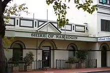
.jpg.webp) The state heritage listed Narrogin Town Hall, 2018 | |||||||||||||||
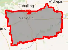
_LGA_WA.png.webp) Location in Western Australia | |||||||||||||||
 | |||||||||||||||
| Population | 5,162 (2016 census)[1] | ||||||||||||||
| • Density | 3.1888/km2 (8.2589/sq mi) | ||||||||||||||
| Established | 1892 | ||||||||||||||
| Area | 1,618.8 km2 (625.0 sq mi) | ||||||||||||||
| Shire president | Leigh Ballard | ||||||||||||||
| Council seat | Narrogin | ||||||||||||||
| Region | Wheatbelt | ||||||||||||||
| State electorate(s) | Roe | ||||||||||||||
| Federal division(s) | O'Connor | ||||||||||||||
| Website | Shire of Narrogin | ||||||||||||||
| |||||||||||||||
History
On 19 May 1892, the Narrogin Road District came into being. On 1 July 1961, it became a Shire under the Local Government Act 1960.[2] In 1999 and 2004, proposals to merge the Shire with the Town of Narrogin were defeated at referendum.[3] In 2016, on July 1, the Shire of Narrogin amalgamated with the Town of Narrogin. The new entity retained the designation of Shire.
Wards
Both the Shire and the Town of Narrogin had wards, but they have since been abolished. Nine elected members now sit at large.
Towns and localities
- Boundain
- Highbury
- Narrogin
- Nomans Lake
- Yilliminning
Population
| Year | Population |
|---|---|
| 1911 | 889 |
| 1921 | 1,117 |
| 1933 | 1,217 |
| 1947 | 844 |
| 1954 | 966 |
| 1961 | 972 |
| 1966 | 1,010 |
| 1971 | 905 |
| 1976 | 843 |
| 1981 | 813 |
| 1986 | 680 |
| 1991 | 862 |
| 1996 | 867 |
| 2001 | 843 |
| 2006 | 830 |
| 2011 | 875 |
| 2016 | 5,162 |
Heritage-listed places
As of 2021, 169 places are heritage-listed in the Shire of Narrogin,[4] of which 23 are on the State Register of Heritage Places.[5]
References
- Australian Bureau of Statistics (27 June 2017). "Narrogin (S)". 2016 Census QuickStats. Retrieved 28 October 2019.
- WA Electoral Commission, Municipality Boundary Amendments Register (release 3.0), 31 July 2007.
- ABC Online (27 February 2004). "Narrogin Shire residents make merger feelings clear". Retrieved 2 November 2006.
- "Shire of Narrogin Heritage Places". inherit.stateheritage.wa.gov.au. Heritage Council of Western Australia. Retrieved 27 March 2021.
- "Shire of Narrogin State Register of Heritage Places". inherit.stateheritage.wa.gov.au. Heritage Council of Western Australia. Retrieved 27 March 2021.