Shire of Goomalling
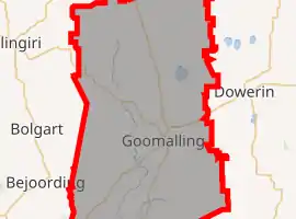
The Shire of Goomalling is a local government area in the Wheatbelt region of Western Australia, about 240 kilometres (149 mi) northeast of Perth, the state capital. The Shire covers an area of 2,836 square kilometres (1,095 sq mi) and its seat of government is the town of Goomalling.
| Shire of Goomalling Western Australia | |||||||||||||||
|---|---|---|---|---|---|---|---|---|---|---|---|---|---|---|---|
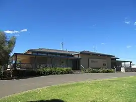 The Goomalling Shire offices | |||||||||||||||
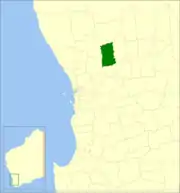 Location in Western Australia | |||||||||||||||
 | |||||||||||||||
| Population | 1,033 (2016 census)[1] | ||||||||||||||
| • Density | 0.56227/km2 (1.4563/sq mi) | ||||||||||||||
| Established | 1895 | ||||||||||||||
| Area | 1,837.2 km2 (709.3 sq mi) | ||||||||||||||
| Shire President | Barry Haywood | ||||||||||||||
| Council seat | Goomalling | ||||||||||||||
| Region | Wheatbelt | ||||||||||||||
| State electorate(s) | Electoral district of Central Wheatbelt | ||||||||||||||
| Federal division(s) | Durack | ||||||||||||||
| Website | Shire of Goomalling | ||||||||||||||
| |||||||||||||||
History
On 18 January 1895, the Goomalling Road District was created. On 1 July 1961, it became a Shire following the enactment of the Local Government Act 1960.[2]
Wards
The shire has been divided into 4 wards:
- Town Ward (4 councillors)
- North Ward (2 councillors)
- South Ward (2 councillors)
- Central Ward (1 councillor)
Towns and localities
- Cunjardine
- Goomalling
- Hulongine
- Jennacubbine
- Karranadgin
- Konnongorring
- Mumberkine
- Rossmore
- Ucarty West
- Wongamine
Population
| Year | Population |
|---|---|
| 1921 | 1,508 |
| 1933 | 1,803 |
| 1947 | 1,403 |
| 1954 | 1,721 |
| 1961 | 1,567 |
| 1966 | 1,567 |
| 1971 | 1,444 |
| 1976 | 1,254 |
| 1981 | 1,269 |
| 1986 | 1,206 |
| 1991 | 1,084 |
| 1996 | 1,035 |
| 2001 | 939 |
| 2006 | 935 |
| 2011 | 985 |
| 2016 | 1,033 |
Heritage-listed places
As of 2021, 36 places are heritage-listed in the Shire of Goomalling,[3] of which two are on the State Register of Heritage Places.[4]
| Place name | Place # | Street name | Suburb or town | Co-ordinates | Built | Stateregistered | Notes & former names | Photo |
|---|---|---|---|---|---|---|---|---|
| Goomalling Post Office & Quarters | 1114 | Railway Terrace | Goomalling | 31.298797°S 116.827049°E | 1910 | 2 June 1998 |  | |
| Slater Homestead | 3522 | Goomalling-Dowerin Road | Goomalling | 31.272924°S 116.845872°E | 1856 | 23 January 2004 |
References
- Australian Bureau of Statistics (27 June 2017). "Goomalling (S)". 2016 Census QuickStats. Retrieved 28 October 2019.
- WA Electoral Commission, Municipality Boundary Amendments Register (release 3.0), 31 July 2007.
- "Shire of Goomalling Heritage Places". inherit.stateheritage.wa.gov.au. Heritage Council of Western Australia. Retrieved 25 March 2021.
- "Shire of Goomalling State Register of Heritage Places". inherit.stateheritage.wa.gov.au. Heritage Council of Western Australia. Retrieved 25 March 2021.
External links
This article is issued from Wikipedia. The text is licensed under Creative Commons - Attribution - Sharealike. Additional terms may apply for the media files.