Cleveland County, North Carolina
Cleveland County is a county located in the foothills of the Blue Ridge Mountains and the western Piedmont, and on the southern border of the U.S. state of North Carolina. As of the 2020 census, the population was 99,519.[1] Its county seat is Shelby.[2]
Cleveland County | |
|---|---|
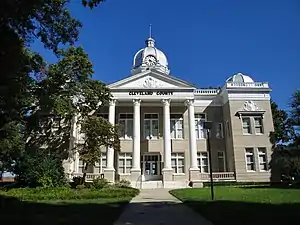 The west side of the old Cleveland County Courthouse, Shelby | |
 Seal | |
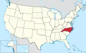
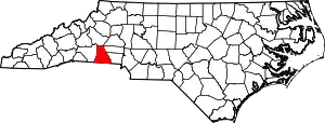 Location within the U.S. state of North Carolina | |
 North Carolina's location within the U.S. | |
| Coordinates: 35°20′N 81°34′W | |
| Country | |
| State | |
| Founded | 1841 |
| Named for | Colonel Benjamin Cleveland |
| Seat | Shelby |
| Largest city | Shelby |
| Area | |
| • Total | 468 sq mi (1,210 km2) |
| • Land | 464 sq mi (1,200 km2) |
| • Water | 4.0 sq mi (10 km2) 0.9%% |
| Population | |
| • Estimate (2021) | 100,359 |
| • Density | 216.3/sq mi (83.5/km2) |
| Time zone | UTC−5 (Eastern) |
| • Summer (DST) | UTC−4 (EDT) |
| Congressional district | 10th |
| Website | www |
Cleveland County comprises the Shelby, NC Micropolitan Statistical Area. This is included in the Charlotte-Concord, NC-SC Combined Statistical Area. In the late 19th and early 20th century, this was an area of textile mills.
History
The county was formed in 1841 from parts of Lincoln and Rutherford counties. It was named for Benjamin Cleveland, a colonel in the American Revolutionary War, who took part in the Battle of King's Mountain. From 1841 to 1887 "Cleaveland" was the spelling used; the present spelling was adopted in 1887.[3]
Geography
According to the U.S. Census Bureau, the county has a total area of 468 square miles (1,210 km2), of which 464 square miles (1,200 km2) is land and 4.0 square miles (10 km2) (0.9%) is water.[4]
Cleveland County is part of the South Mountains, a sub-range of the Blueridge Mountains that runs through the county's northwest corner. In the south east corner of the county is Crowders & Kings Mountains, part of a small narrow ridge that sits above the very near surrounding area. They are part of a very old remnant of The Appalachians and used to be much larger. Overall Cleveland County is very hilly, and even mountainous in certain parts, though not to the extreme as counties to the west or north.
State and local protected areas
- City of Shelby Hanna Park
- Crowders Mountain State Park (part)
- Fallen Heroes Memorial at Raper-Roark Park
- John H. Moss Lake Recreation Park
- Kings Mountain Gateway Trail
- Optimist Park
- Palmer Park
- Running Trail
- Springs Area
- Twin Trestle Trailhead
Adjacent counties
- Burke County - north
- Lincoln County - east
- Gaston County - east
- York County, South Carolina - south
- Cherokee County, South Carolina - south
- Rutherford County - west
Major water-bodies
- Benson Creek
- Broad River
- Buffalo Creek
- Hilton Creek
- Kings Mountain Reservoir
- Little Buffalo Creek
- Little Persimmon Creek
- Long Branch
- Nettle Branch
- Persimmon Creek
- Suck Creek
Demographics
| Historical population | |||
|---|---|---|---|
| Census | Pop. | %± | |
| 1850 | 10,396 | — | |
| 1860 | 12,348 | 18.8% | |
| 1870 | 12,696 | 2.8% | |
| 1880 | 16,571 | 30.5% | |
| 1890 | 20,394 | 23.1% | |
| 1900 | 25,078 | 23.0% | |
| 1910 | 29,494 | 17.6% | |
| 1920 | 34,272 | 16.2% | |
| 1930 | 51,914 | 51.5% | |
| 1940 | 58,055 | 11.8% | |
| 1950 | 64,357 | 10.9% | |
| 1960 | 66,048 | 2.6% | |
| 1970 | 72,556 | 9.9% | |
| 1980 | 83,435 | 15.0% | |
| 1990 | 84,714 | 1.5% | |
| 2000 | 96,287 | 13.7% | |
| 2010 | 98,078 | 1.9% | |
| 2020 | 99,519 | 1.5% | |
| 2021 (est.) | 100,359 | [5] | 2.3% |
2020 census
| Race | Number | Percentage |
|---|---|---|
| White (non-Hispanic) | 70,163 | 70.5% |
| Black or African American (non-Hispanic) | 20,034 | 20.13% |
| Native American | 222 | 0.22% |
| Asian | 854 | 0.86% |
| Pacific Islander | 23 | 0.02% |
| Other/Mixed | 4,184 | 4.2% |
| Hispanic or Latino | 4,039 | 4.06% |
As of the 2020 United States census, there were 99,519 people, 30,599 households, and 21,410 families residing in the county.
2010 census
As of the census[7] of 2010, there were 98,078 people, 37,046 households, and 27,006 families residing in the county. The population density was 207 people per square mile (80/km2). There were 40,317 housing units at an average density of 87 per square mile (34/km2). The racial makeup of the county was 74% White, 21% Black or African American, 0.15% Native American, 0.69% Asian, 0.01% Pacific Islander, 0.68% from other races, and 0.72% from two or more races. Of any race, 3% of the population were Hispanic or Latino.
There were 37,046 households, out of which 32.20% had children under the age of 18 living with them, 55.00% were married couples living together, 13.70% had a female householder with no husband present, and 27.10% were non-families. 23.60% of all households were made up of individuals, and 9.60% had someone living alone who was 65 years of age or older. The average household size was 2.53 and the average family size was 2.98.
In the county, the age distribution of the population shows 25.20% under the age of 18, 8.80% from 18 to 24, 28.80% from 25 to 44, 23.70% from 45 to 64, and 13.50% who were 65 years of age or older. The median age was 36 years. For every 100 females there were 92.60 males. For every 100 females age 18 and over, there were 88.60 males.
The median income for a household in the county was $35,283, and the median income for a family was $41,733. Males had a median income of $30,882 versus $21,995 for females. The per capita income for the county was $17,395. About 10.10% of families and 13.30% of the population were below the poverty line, including 17.90% of those under age 18 and 14.00% of those age 65 or over.
Communities
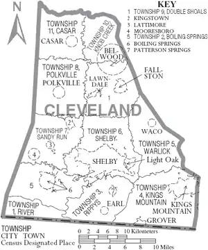
Cities
- Kings Mountain (small section is a part of Gaston County)
- Shelby (county seat and largest city)
Towns
Census-designated place
Unincorporated community
Politics, law and government
Cleveland is a typical "Solid South" county in its voting patterns. It was Democratic until 1968 when a majority voted for George Wallace. In 1972 the county voted overwhelmingly for Richard Nixon, and since then Cleveland has become strongly Republican. The last Democrat to carry Cleveland County was Jimmy Carter in 1980.
| Year | Republican | Democratic | Third party | |||
|---|---|---|---|---|---|---|
| No. | % | No. | % | No. | % | |
| 2020 | 33,798 | 65.87% | 16,955 | 33.05% | 555 | 1.08% |
| 2016 | 28,479 | 63.75% | 14,964 | 33.50% | 1,230 | 2.75% |
| 2012 | 25,793 | 59.51% | 17,062 | 39.37% | 485 | 1.12% |
| 2008 | 26,078 | 59.49% | 17,363 | 39.61% | 394 | 0.90% |
| 2004 | 22,750 | 61.36% | 14,215 | 38.34% | 114 | 0.31% |
| 2000 | 19,064 | 58.22% | 13,455 | 41.09% | 227 | 0.69% |
| 1996 | 13,474 | 47.71% | 12,728 | 45.07% | 2,039 | 7.22% |
| 1992 | 13,650 | 44.72% | 13,037 | 42.71% | 3,835 | 12.56% |
| 1988 | 14,039 | 57.54% | 10,321 | 42.30% | 37 | 0.15% |
| 1984 | 17,095 | 62.23% | 10,288 | 37.45% | 89 | 0.32% |
| 1980 | 10,828 | 46.08% | 12,219 | 52.00% | 451 | 1.92% |
| 1976 | 8,106 | 35.89% | 14,406 | 63.78% | 76 | 0.34% |
| 1972 | 13,726 | 72.06% | 4,994 | 26.22% | 328 | 1.72% |
| 1968 | 7,298 | 32.28% | 5,661 | 25.04% | 9,649 | 42.68% |
| 1964 | 7,874 | 42.08% | 10,836 | 57.92% | 0 | 0.00% |
| 1960 | 8,257 | 43.92% | 10,545 | 56.08% | 0 | 0.00% |
| 1956 | 7,076 | 45.70% | 8,408 | 54.30% | 0 | 0.00% |
| 1952 | 7,606 | 43.93% | 9,709 | 56.07% | 0 | 0.00% |
| 1948 | 1,905 | 20.57% | 6,039 | 65.21% | 1,317 | 14.22% |
| 1944 | 2,636 | 24.39% | 8,170 | 75.61% | 0 | 0.00% |
| 1940 | 1,970 | 17.41% | 9,346 | 82.59% | 0 | 0.00% |
| 1936 | 2,116 | 15.66% | 11,393 | 84.34% | 0 | 0.00% |
| 1932 | 1,904 | 19.15% | 8,016 | 80.60% | 25 | 0.25% |
| 1928 | 4,766 | 49.24% | 4,914 | 50.76% | 0 | 0.00% |
| 1924 | 1,743 | 31.52% | 3,749 | 67.81% | 37 | 0.67% |
| 1920 | 2,953 | 36.30% | 5,181 | 63.70% | 0 | 0.00% |
| 1916 | 1,497 | 35.13% | 2,764 | 64.87% | 0 | 0.00% |
| 1912 | 81 | 2.40% | 2,351 | 69.66% | 943 | 27.94% |
Cleveland County is a member of the Isothermal Planning and Development Commission[10][11] regional council of governments.
Education
Cleveland County Schools
Cleveland County Schools has 29 schools ranging from pre-kindergarten to twelfth grade, comprising five high schools, two alternative schools, four middle schools, two intermediate schools (grades 5 and 6), and sixteen elementary schools.[12] It was formed from the 2004 merger of Kings Mountain City Schools, Shelby City Schools and the former Cleveland County Schools.[13][14]
Post-secondary
- Ambassador Bible College in Lattimore, North Carolina[15]
- Cleveland Community College
- Gardner–Webb University
In popular culture
The 2000 disappearance of Asha Degree, a Shelby girl, was discussed on television shows including America's Most Wanted, The Oprah Winfrey Show, Good Morning America, and The Montel Williams Show.[16][17]
Parts of the 2012 movie The Hunger Games were filmed in Cleveland County.[18]
Notable people
- Tamara P. Barringer, former state legislator and Associate Justice of the North Carolina Supreme Court
- Bobby Bell, NFL Hall of Fame inductee
- Alicia Bridges, disco singer
- W. J. Cash, author of The Mind of the South
- Bill Champion, MLB player.[19]
- Morris Davis, Colonel in US Air Force
- Thomas Dixon Jr., minister, author
- Manny Fernandez, "The Raging Bull", professional wrestler
- David Flair, professional wrestler
- Alvin Gentry, NBA Coach
- Don Gibson, Country Music Hall of Fame inductee
- Pleasant Daniel Gold, American publisher and Baptist minister
- Kay Hagan, Senator from North Carolina.[20]
- Robert Harrill, The Fort Fisher Hermit
- Keith E. Haynes, Maryland statesman, lawyer
- Norris Hopper, MLB player
- Hatcher Hughes, Pulitzer Prize winner
- Charlie Justice, NFL player, two-time Heisman Trophy runner-up
- Doug Limerick, ABC radio newscaster
- Patty Loveless, country music singer
- Leroy McAfee – Confederate soldier, Ku Klux Klan organizer, and member of the North Carolina House of Representatives (1870–73).
- Manteo Mitchell, Olympic Silver Medalist, World Champion, US Champion, International Icon in Track & Field
- Scottie Montgomery, NFL wide receiver, Oakland Raiders, Arena Football League player
- Tim Moore (North Carolina politician), member of the General Assembly since 2003 and elected Speaker of the North Carolina State House in 2015, has lived in the county since 1997 and has his law practice there.
- Travis Padgett, Olympic athlete in track and field
- Floyd Patterson, heavyweight boxing champion, Boxing Hall Of Fame inductee
- Rodney Allen Rippy, former child actor
- Earl Scruggs, banjo player and composer, included on Hollywood Walk of Fame
- Isaac Shelby, soldier, governor
- Charlotte Smith, WNBA basketball player
- Brandon Spikes, professional football linebacker
- Billy Standridge, NASCAR driver
- Tim Steele, 3-time ARCA champion, NASCAR driver
- David Thompson, Hall of Fame college and professional basketball player
- Cliff Washburn, NFL offensive tackle, Houston Texans
- Tim Wilkison, tennis player
- Tom Wright, MLB player.[21]
- Jonathan Bullard, NFL DE, Chicago Bears. Former Crest High School and the University of Florida football great.
- A.G.Riddle, New York Times Best selling author of, “The Atlantis Gene.”
See also
References
- "U.S. Census Bureau QuickFacts: Cleveland County, North Carolina". www.census.gov. Retrieved April 30, 2022.
- "Find a County". National Association of Counties. Archived from the original on May 31, 2011. Retrieved June 7, 2011.
- "Cleaveland County, North Carolina" Archived 2012-07-19 at archive.today, Mousely.com, Retrieved 2010-12-30.
- "2010 Census Gazetteer Files". United States Census Bureau. August 22, 2012. Archived from the original on January 12, 2015. Retrieved January 13, 2015.
- "U.S. Census Bureau QuickFacts: Cleveland County, North Carolina". www.census.gov. Retrieved April 30, 2022.
- "Explore Census Data". data.census.gov. Retrieved December 21, 2021.
- "U.S. Census website". United States Census Bureau. Retrieved January 31, 2008.
- U.S. Census Bureau. "Guide to State and Local Census Geography" (PDF). Archived from the original (PDF) on December 10, 2016. (updated for 2010 Census)
- Leip, David. "Dave Leip's Atlas of U.S. Presidential Elections". uselectionatlas.org. Retrieved March 15, 2018.
- Isothermal Planning and Development Commission (regional council) Archived 2014-07-07 at archive.today
- Isothermal Planning and Development Commission (NC Tomorrow) Archived 2014-07-14 at the Wayback Machine
- "Schools". Cleveland County Schools. Archived from the original on July 29, 2012. Retrieved January 8, 2013.
- "Court affirms school merger approved by the State Board of Education". University of North Carolina School of Government. Summer 2003. Archived from the original on February 23, 2013. Retrieved January 8, 2013.
- "Moore Will Head Merged Schools, Parents Await First Changes to Cleveland County School System". The Charlotte Observer. January 14, 2004. p. 2B.
- "Contact ABC". Ambassador Bible College. Retrieved September 8, 2012.
- http://www.shelbystar.com/articles/morning-49662-degree-america.html
- EndPlay (September 9, 2010). "'Good Morning America' Profiles Local Girl's Disappearance". WSOC. Retrieved March 15, 2018.
- Pickens, Jessica. "Cleveland County, NC, a popular spot for filming movies, TV shows". Halifax Media Group. Retrieved January 30, 2014.
- "Bill Champion's career statistics". baseball-reference.com. Retrieved March 29, 2009.
- "About Kay Hagan". United States Senate. Archived from the original on May 27, 2009. Retrieved May 12, 2009.
- "Tom Wright's career statistics". retrosheet.org. Retrieved September 8, 2008.
External links
- Cleveland County government official website
- Cleveland County Online Taxes web site
- Cleveland Community College official website
Places adjacent to Cleveland County, North Carolina | ||||||||||||||||
|---|---|---|---|---|---|---|---|---|---|---|---|---|---|---|---|---|
| ||||||||||||||||
Municipalities and communities of Cleveland County, North Carolina, United States | ||
|---|---|---|
| Cities | 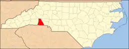 | |
| Towns | ||
| CDP | ||
| Unincorporated communities | ||
| Indian reservation | ||
| Footnotes | ‡This populated place also has portions in an adjacent county or counties | |
| ||
|  | ||||||||||||
|
| |||||||||||||