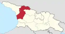
Samegrelo-Zemo Svaneti
Samegrelo-Zemo Svaneti (Georgian: სამეგრელო-ზემო სვანეთი) is a region (Mkhare) in western Georgia with a population of 308,358 (2021[3]) and a surface of 7,468 km2 (2,883 sq mi).[2] The region has Zugdidi as its administrative center, while Giorgi Guguchia is governor of the region since June 2021.[5][6] Samegrelo-Zemo Svaneti is compiled of the historical Georgian provinces of Samegrelo Mingrelia and Zemo Svaneti (i.e., Upper Svaneti).
Samegrelo-Zemo Svaneti
სამეგრელო-ზემო სვანეთი | |
|---|---|
Mkhare (region) | |
 | |
| Country | |
| Capital | Zugdidi |
| Subdivisions | 1 city, 8 municipalities[1] |
| Government | |
| • Governor | Giorgi Guguchia (2 juni 2021) |
| Area | |
| • Total | 7,468 km2 (2,883 sq mi) |
| Population (2021) | |
| • Total | 308,358[3] |
| ISO 3166 code | GE-SZ |
| HDI (2017) | 0.757[4] high · 5th |
Subdivisions
The region has one self governing city (Poti) and 8 municipalities with 143 administrative communities (temi),[2] totalling to 531 populated settlements:
- Eight cities: Abasha, Khobi, Martvili, Poti, Jvari, Zugdidi, Senaki and Tsalenjikha.
- Two dabas: Mestia, Chkhorotsku
- Villages: 521

Geography
Samegrelo-Zemo Svaneti is traversed by two sections of the northeasterly line of equal latitude and longitude.
Demographic
| Population development of the region Samegrelo-Zemo Svaneti[7] | ||||||||||||||||||
|---|---|---|---|---|---|---|---|---|---|---|---|---|---|---|---|---|---|---|
| 1959 | 1970 | 1979 | 1989 | 2002* | 2002** | 2014 | 2021 | |||||||||||
| Abasha Municipality | 30,286 | - | ||||||||||||||||
| Khobi Municipality | 31,280 | - | ||||||||||||||||
| Martvili Municipality | 47,777 | - | ||||||||||||||||
| Mestia Municipality | 16,311 | - | ||||||||||||||||
| City of Poti | 48,117 | - | ||||||||||||||||
| Senaki Municipality | 47,553 | - | ||||||||||||||||
| Tsalenjikha Municipality | 29,019 | - | ||||||||||||||||
| Chkhorotsku Municipality | 27,647 | - | ||||||||||||||||
| Zugdidi Municipality | 96,643 | - | ||||||||||||||||
| Samegrelo-Zemo Svaneti | 374,633 | 466,100 | ||||||||||||||||
| * Research after 2014 census showed the 2002 census was inflated by 8-9 percent.[8] **Corrected data based on retro-projection 1994-2014 in collaboration with UN[9] | ||||||||||||||||||
Ethnic groups
According to the Georgian census of 2014,[2] 99.37% of the population is Georgian and 0.35% is Russian. Other ethnic groups living in the region include Ukrainians, Armenians, Abkhazians and Greeks.
Languages
Georgian is spoken by the entire population of the region and by the ethnic minorities like Russians and others. Mingrelian is a Kartvelian language spoken by the Mingrels, a sub-group of Georgian people and native to Mingrelia. Svan is also a Kartvelian language, spoken by the Svans, a sub-group of Georgian people native to Svaneti.
Religion
About 99% of the population identifies as Orthodox Christians. A little minority of Armenian Christians and Roman Catholics also exist.
References
- "Regions and muncipalities of Georgia" (in Georgian). Georgian Government. Retrieved 2022-02-04.
- "Main Results of the 2014 Census (Publication)" (PDF). Census.ge, National Statistics Office of Georgia (Geostat) (in Georgian). 2016-04-28. p. 229. Retrieved 2022-02-04.
- "Population and Demography - Population as of 1 January by regions and urban-rural settlements". Retrieved 2021-11-23.
- "Sub-national HDI - Area Database - Global Data Lab". hdi.globaldatalab.org. Retrieved 2018-09-13.
- "Giorgi Guguchia Appointed Governor of Samegrelo-Zemo Svaneti". Georgia Today. 2021-06-02. Retrieved 2022-02-04.
- "State Representative of Samegrelo-Zemo Svaneti". Samegrelo-Zemo Svaneti website (in Georgian). 2021-06-02. Retrieved 2022-02-04.
- "Divisions of Georgia". Population Statistics Eastern Europe and former USSR. Retrieved 2022-02-04.
- "Population Dynamics in Georgia - An Overview Based on the 2014 General Population Census Data" (PDF). National Statistics Office of Georgia, Geostat. 2017-11-29. pp. 1–4. Retrieved 2022-02-04.
- "Retro-projection of main demographic indicators for the period 1994-2014". National Statistics Office of Georgia, Geostat. 2018-05-18. pp. 3, Table 1. Retrieved 2022-02-04.
External links
| Autonomous republics | .svg.png.webp) | |
|---|---|---|
| Regions | ||
| City with special status |
| |
| Other | ||