Sainte-Geneviève-de-Berthier, Quebec
Sainte-Geneviève-de-Berthier is a municipality in the Lanaudière region of Quebec, Canada, part of the D'Autray Regional County Municipality. It is crossed by the river La Chaloupe. The Saint-Joseph River also passes over 2.1 km in the southwestern part of the municipal territory.
Sainte-Geneviève-de-Berthier | |
|---|---|
 | |
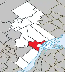 Location within D'Autray RCM | |
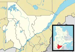 Sainte-Geneviève-de-Berthier Location in central Quebec | |
| Coordinates: 46°05′N 73°13′W[1] | |
| Country | Canada |
| Province | Quebec |
| Region | Lanaudière |
| RCM | D'Autray |
| Constituted | July 1, 1855 |
| Government | |
| • Mayor | Robert Pufahl |
| • Federal riding | Berthier—Maskinongé |
| • Prov. riding | Berthier |
| Area | |
| • Total | 73.20 km2 (28.26 sq mi) |
| • Land | 67.03 km2 (25.88 sq mi) |
| Population (2021)[3] | |
| • Total | 2,253 |
| • Density | 33.6/km2 (87/sq mi) |
| • Pop 2016-2021 | |
| • Dwellings | 977 |
| Time zone | UTC−5 (EST) |
| • Summer (DST) | UTC−4 (EDT) |
| Postal code(s) | |
| Area code(s) | 450 and 579 |
| Highways | |
| Website | municipalites-du-quebec |
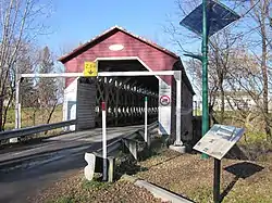
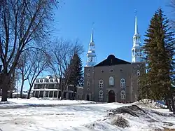
It is home to the Sainte-Geneviève church which forms an enclave within the city of Berthierville belonging to Sainte-Geneviève-de-Berthier. The church was classified as a heritage site in 2001[4] and is named in honor of Saint Genevieve. Is is also home to the Grandchamp covered bridge which is recognized as a listed heritage asset[5] and the Grande Côte Road witch is known for its large ancestral houses.
Neighborhoods
- Berthier County
- Paquin
- Rivière-Bayonne
- Ruisseau des Terres-Noires
History
Originally, the territory were Sainte-Geneviève-de-Berthier currently sit was known as Berthier, en haut. On July 1, 1849. the municipality of Berthier numéro un was created, witch consisted of most of the current D'Autray RCM. In 1852, the future town of Berthierville (then known only as Berthier) split from the municipality and on July 1, 1855, the municipality disband entirely, creating 8 new town: Saint-Antoine-de-la-Valtrie, L'Isle-du-Pads, Saint-Barthélemi, Saint-Joseph-de-Lanoraie, Saint-Gabriel-de-Brandon, Sainte-Elizabeth, Saint-Cuthbert and Berthier-en-Haut, which, on March 13, 1969, changed its name to the current Sainte-Geneviève-de-Berthier in honor of Saint Genevieve the patroness saint of Paris.[6]
Demographics
Population
| 2016 | 2011 | |
|---|---|---|
| Population | 2,280 (-3.6% from 2011) | 2,365 (+2.5% from 2006) |
| Land area | 67.62 km2 (26.11 sq mi) | 66.69 km2 (25.75 sq mi) |
| Population density | 33.7/km2 (87/sq mi) | 35.5/km2 (92/sq mi) |
| Median age | 46.1 (M: 45.5, F: 46.9) | 44.9 (M: 44.9, F: 45.0) |
| Total private dwellings | 981 | 962 |
| Median household income | $65,024 | $.N/A |
| Year | Pop. | ±% |
|---|---|---|
| 1996 | 2,402 | — |
| 2001 | 2,387 | −0.6% |
| 2006 | 2,307 | −3.4% |
| 2011 | 2,365 | +2.5% |
| 2016 | 2,280 | −3.6% |
| 2021 | 2,253 | −1.2% |
| Source: [11] | ||
Language
Mother tongue:
- English as first language: 0.7%
- French as first language: 96.7%
- English and French as first language: 0%
- Other as first language: 2.6%
Education
The Sir Wilfrid Laurier School Board operates anglophone public schools, including:
- Joliette Elementary School in Saint-Charles-Borromée[12]
- Joliette High School in Joliette[13]
See also
References
- Reference number 417963 of the Commission de toponymie du Québec (in French)
- Geographic code 52040 in the official Répertoire des municipalités (in French)
- Statistics Canada 2011 Census - Sainte-Geneviève-de-Berthier census profile
- "Église de Sainte-Geneviève - Répertoire du patrimoine culturel du Québec".
- "Pont couvert Grandchamp - Répertoire du patrimoine culturel du Québec".
- "PADREM Québec - Prosopographie Répertoire Québec".
- "2016 Community Profiles". 2016 Canadian Census. Statistics Canada. August 12, 2021. Retrieved 2022-04-20.
- "2011 Community Profiles". 2011 Canadian Census. Statistics Canada. March 21, 2019. Retrieved 2022-04-20.
- "2006 Community Profiles". 2006 Canadian Census. Statistics Canada. August 20, 2019.
- "2001 Community Profiles". 2001 Canadian Census. Statistics Canada. July 18, 2021.
- Statistics Canada: 1996, 2001, 2006, 2011, 2016, 2021 census
- "JOLIETTE ELEMENTARY ZONE." Sir Wilfrid Laurier School Board. Retrieved on September 17, 2017.
- "Joliette High School Zone Sec 1-5." Sir Wilfrid Laurier School Board. Retrieved on September 5, 2017.
External links
![]() Media related to Sainte-Geneviève-de-Berthier at Wikimedia Commons
Media related to Sainte-Geneviève-de-Berthier at Wikimedia Commons
Adjacent Municipal Subdivisions | |
|---|---|
| Cities & Towns | |
|---|---|
| Municipalities | |
| Parishes | |
| |