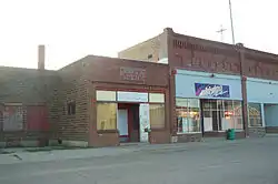
St. Thomas, North Dakota
St. Thomas is a town in Pembina County, North Dakota, United States. The town, located in the Red River Valley region, had a population of 307 as of the 2020 census.[5]
St. Thomas, North Dakota | |
|---|---|
 St. Thomas, North Dakota | |
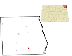 Location of St. Thomas, North Dakota | |
| Coordinates: 48°37′11″N 97°26′48″W | |
| Country | United States |
| State | North Dakota |
| County | Pembina |
| Founded | 1881 |
| Area | |
| • Total | 1.01 sq mi (2.63 km2) |
| • Land | 1.01 sq mi (2.63 km2) |
| • Water | 0.00 sq mi (0.00 km2) |
| Elevation | 840 ft (256 m) |
| Population | |
| • Total | 307 |
| • Estimate (2021)[3] | 303 |
| • Density | 298/sq mi (115/km2) |
| Time zone | UTC-6 (Central (CST)) |
| • Summer (DST) | UTC-5 (CDT) |
| ZIP codes | 58276 |
| Area code(s) | 701 |
| FIPS code | 38-70260 |
| GNIS feature ID | 1031303[4] |
History
St. Thomas was laid out in 1881.[6] The city was named after St. Thomas, Ontario.[7]
A U.S. post office has been in operation at St. Thomas since 1881 and is open weekdays.[8]
The St. Thomas Public School was established in 1882. St. Thomas Elementary School and St. Thomas High School offered classes for pre-kindergarten through 12th grade through the 2020-21 school year. The three-person class of 2021 was the last class to graduate from St. Thomas Public School. Pre-K-12th grade students from St. Thomas now attend school in Grafton, ND (in the newly consolidated Grafton School District #18).[9]
Geography
St. Thomas is located at 48°37′11″N 97°26′48″W (48.619637, -97.446704).[10]
According to the United States Census Bureau, the city has a total area of 1.06 square miles (2.75 km2), all land.[11]
Demographics
| Historical population | |||
|---|---|---|---|
| Census | Pop. | %± | |
| 1890 | 477 | — | |
| 1900 | 661 | 38.6% | |
| 1910 | 513 | −22.4% | |
| 1920 | 500 | −2.5% | |
| 1930 | 595 | 19.0% | |
| 1940 | 503 | −15.5% | |
| 1950 | 566 | 12.5% | |
| 1960 | 660 | 16.6% | |
| 1970 | 508 | −23.0% | |
| 1980 | 528 | 3.9% | |
| 1990 | 444 | −15.9% | |
| 2000 | 447 | 0.7% | |
| 2010 | 331 | −26.0% | |
| 2019 (est.) | 311 | [3] | −6.0% |
| U.S. Decennial Census[12] 2018 Estimate[13] | |||
2020 census
In 2020 307 people lived in St. Thomas.[14] Three-quarters of those residents were born in or near the town itself. It is a racially and ethnically diverse town, where 16% of residents are Latino, 8% are Indigenous, and most other residents are white. According to the census, every man who lives in the town owns his home, and 75% of women do too.
2010 census
As of the census[2] of 2010, there were 331 people, 150 households, and 107 families residing in the city. The population density was 312.3 inhabitants per square mile (120.6/km2). There were 182 housing units at an average density of 171.7 per square mile (66.3/km2). The racial makeup of the city was 94.6% White, 0.6% Native American, 4.5% from other races, and 0.3% from two or more races. Hispanic or Latino of any race were 19.6% of the population.
There were 150 households, of which 27.3% had children under the age of 18 living with them, 53.3% were married couples living together, 9.3% had a female householder with no husband present, 8.7% had a male householder with no wife present, and 28.7% were non-families. 27.3% of all households were made up of individuals, and 11.3% had someone living alone who was 65 years of age or older. The average household size was 2.21 and the average family size was 2.63.
The median age in the city was 46.1 years. 19.6% of residents were under the age of 18; 5.7% were between the ages of 18 and 24; 21.7% were from 25 to 44; 35.2% were from 45 to 64; and 17.8% were 65 years of age or older. The gender makeup of the city was 52.6% male and 47.4% female.
2000 census
As of the census of 2000, there were 447 people, 174 households, and 123 families residing in the city. The population density was 421.7 people per square mile (162.8/km2). There were 201 housing units at an average density of 189.6 per square mile (73.2/km2). The racial makeup of the city was 94.18% White, 4.25% from other races, and 1.57% from two or more races. Hispanic or Latino of any race were 19.02% of the population.
There were 174 households, out of which 32.2% had children under the age of 18 living with them, 56.3% were married couples living together, 8.0% had a female householder with no husband present, and 29.3% were non-families. 26.4% of all households were made up of individuals, and 14.9% had someone living alone who was 65 years of age or older. The average household size was 2.57 and the average family size was 3.13.
In the city, the population was spread out, with 29.8% under the age of 18, 4.0% from 18 to 24, 26.8% from 25 to 44, 23.5% from 45 to 64, and 15.9% who were 65 years of age or older. The median age was 37 years. For every 100 females, there were 103.2 males. For every 100 females age 18 and over, there were 100.0 males.
The median income for a household in the city was $31,094, and the median income for a family was $44,375. Males had a median income of $26,023 versus $22,083 for females. The per capita income for the city was $18,222. About 14.3% of families and 17.3% of the population were below the poverty line, including 23.0% of those under age 18 and 16.4% of those age 65 or over.
Notable people
- Edward K. Thompson, editor of LIFE magazine and SMITHSONIAN magazine
- Thomas Whelan, United States Ambassador to Nicaragua, 1951 to 1961
References
- "2019 U.S. Gazetteer Files". United States Census Bureau. Retrieved July 27, 2020.
- "U.S. Census website". United States Census Bureau. Retrieved June 14, 2012.
- "Population and Housing Unit Estimates". United States Census Bureau. May 24, 2020. Retrieved May 27, 2020.
- "US Board on Geographic Names". United States Geological Survey. October 25, 2007. Retrieved January 31, 2008.
- "St. Thomas, North Dakota Population 2021 (Demographics, Maps, Graphs)". worldpopulationreview.com. Retrieved 2021-09-22.
- "Cities". County of Pembina, North Dakota. Archived from the original on February 18, 2015. Retrieved October 26, 2015.
{{cite web}}: CS1 maint: unfit URL (link) - Federal Writer's Project of the Works Progress Administration for the State of North Dakota (1977). The WPA Guide To 1930s North Dakota (2nd ed.). State Historical Society of North Dakota. p. 188. ISBN 1891419145.
- "Pembina County". Jim Forte Postal History. Retrieved October 25, 2015.
- Thingelstad, Pete (2021). STHS, Final Curtain Call, Senior Graduates 1899-2021. St. Thomas, ND: self published. p. 4.
- "US Gazetteer files: 2010, 2000, and 1990". United States Census Bureau. February 12, 2011. Retrieved April 23, 2011.
- "US Gazetteer files 2010". United States Census Bureau. Archived from the original on January 12, 2012. Retrieved June 14, 2012.
- United States Census Bureau. "Census of Population and Housing". Retrieved August 30, 2013.
- "Population Estimates". United States Census Bureau. Retrieved June 18, 2019.
- "St. Thomas, North Dakota Population 2021 (Demographics, Maps, Graphs)". worldpopulationreview.com. Retrieved 2021-09-22.
External links
| Wikimedia Commons has media related to St. Thomas, North Dakota. |
- Pioneer Women's Histories : St. Thomas and Glasston from the Digital Horizons website
- A century of St. Thomas times (1980) from the Digital Horizons website
Municipalities and communities of Pembina County, North Dakota, United States | ||
|---|---|---|
| Cities | 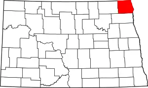 Map of North Dakota highlighting Pembina County | |
| Townships | ||
| Unincorporated communities | ||
| ||