Saint-Pierre-lès-Nemours
Saint-Pierre-lès-Nemours (French pronunciation: [sɛ̃ pjɛʁ lɛ nəmuʁ] (![]() listen), literally Saint-Pierre near Nemours) is a commune in the Seine-et-Marne department in the Île-de-France region in north-central France.
listen), literally Saint-Pierre near Nemours) is a commune in the Seine-et-Marne department in the Île-de-France region in north-central France.
Saint-Pierre-lès-Nemours | |
|---|---|
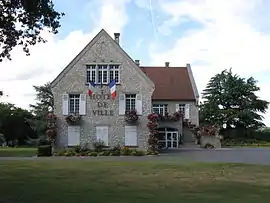 The town hall in Saint-Pierre-lès-Nemours | |
 Coat of arms | |
Location of Saint-Pierre-lès-Nemours 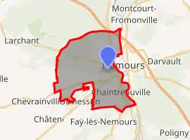 | |
 Saint-Pierre-lès-Nemours  Saint-Pierre-lès-Nemours | |
| Coordinates: 48°15′48″N 2°40′53″E | |
| Country | France |
| Region | Île-de-France |
| Department | Seine-et-Marne |
| Arrondissement | Fontainebleau |
| Canton | Nemours |
| Government | |
| • Mayor (2020–2026) | Bruno Landais[1] |
| Area 1 | 21.62 km2 (8.35 sq mi) |
| Population | 5,394 |
| • Density | 250/km2 (650/sq mi) |
| Time zone | UTC+01:00 (CET) |
| • Summer (DST) | UTC+02:00 (CEST) |
| INSEE/Postal code | 77431 /77140 |
| Elevation | 57–123 m (187–404 ft) |
| 1 French Land Register data, which excludes lakes, ponds, glaciers > 1 km2 (0.386 sq mi or 247 acres) and river estuaries. | |
Demographics
Inhabitants of Saint-Pierre-lès-Nemours are called Saint-Pierrois.
Economy
References
- "Répertoire national des élus: les maires". data.gouv.fr, Plateforme ouverte des données publiques françaises (in French). 9 August 2021.
- "Populations légales 2019". The National Institute of Statistics and Economic Studies. 29 December 2021.
External links
| Wikimedia Commons has media related to Saint-Pierre-lès-Nemours. |
- 1999 Land Use, from IAURIF (Institute for Urban Planning and Development of the Paris-Île-de-France région) (in English)
- Base Mérimée: Search for heritage in the commune, Ministère français de la Culture. (in French)
This article is issued from Wikipedia. The text is licensed under Creative Commons - Attribution - Sharealike. Additional terms may apply for the media files.