Saint-Léger-lès-Paray
Saint-Léger-lès-Paray (French pronunciation: [sɛ̃.leʒe.lɛ.paʁɛ]) is a commune in the Saône-et-Loire department in the region of Bourgogne-Franche-Comté in eastern France.
Saint-Léger-lès-Paray | |
|---|---|
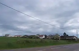 A general view of Saint-Léger-lès-Paray | |
 Coat of arms | |
Location of Saint-Léger-lès-Paray 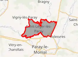 | |
 Saint-Léger-lès-Paray  Saint-Léger-lès-Paray | |
| Coordinates: 46°28′28″N 4°05′23″E | |
| Country | France |
| Region | Bourgogne-Franche-Comté |
| Department | Saône-et-Loire |
| Arrondissement | Charolles |
| Canton | Paray-le-Monial |
| Government | |
| • Mayor (2020–2026) | Éric Bourdais |
| Area 1 | 13.37 km2 (5.16 sq mi) |
| Population | 748 |
| • Density | 56/km2 (140/sq mi) |
| Time zone | UTC+01:00 (CET) |
| • Summer (DST) | UTC+02:00 (CEST) |
| INSEE/Postal code | 71439 /71600 |
| Elevation | 234–303 m (768–994 ft) (avg. 240 m or 790 ft) |
| 1 French Land Register data, which excludes lakes, ponds, glaciers > 1 km2 (0.386 sq mi or 247 acres) and river estuaries. | |
Geography
The Bourbince forms the commune's southwestern border.
References
- "Populations légales 2019". The National Institute of Statistics and Economic Studies. 29 December 2021.
| Wikimedia Commons has media related to Saint-Léger-lès-Paray. |
This article is issued from Wikipedia. The text is licensed under Creative Commons - Attribution - Sharealike. Additional terms may apply for the media files.