Saint-Jean-lès-Longuyon
Saint-Jean-lès-Longuyon (French pronunciation: [sɛ̃ ʒɑ̃ lɛ lɔ̃ɡɥijɔ̃], literally Saint-Jean near Longuyon) is a commune in the Meurthe-et-Moselle department in north-eastern France.[2]
Saint-Jean-lès-Longuyon | |
|---|---|
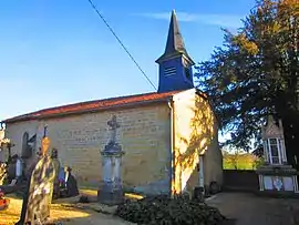 The church in Saint-Jean-lès-Longuyon | |
 Coat of arms | |
Location of Saint-Jean-lès-Longuyon 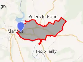 | |
 Saint-Jean-lès-Longuyon  Saint-Jean-lès-Longuyon | |
| Coordinates: 49°27′16″N 5°27′56″E | |
| Country | France |
| Region | Grand Est |
| Department | Meurthe-et-Moselle |
| Arrondissement | Briey |
| Canton | Mont-Saint-Martin |
| Government | |
| • Mayor (2020–2026) | Alain Sirot |
| Area 1 | 4.21 km2 (1.63 sq mi) |
| Population | 416 |
| • Density | 99/km2 (260/sq mi) |
| Time zone | UTC+01:00 (CET) |
| • Summer (DST) | UTC+02:00 (CEST) |
| INSEE/Postal code | 54476 /54260 |
| Elevation | 198–313 m (650–1,027 ft) (avg. 210 m or 690 ft) |
| 1 French Land Register data, which excludes lakes, ponds, glaciers > 1 km2 (0.386 sq mi or 247 acres) and river estuaries. | |
Geography
The village lies on the right bank of the Othain, which forms all of the commune's western border.
References
| Wikimedia Commons has media related to Saint-Jean-lès-Longuyon. |
This article is issued from Wikipedia. The text is licensed under Creative Commons - Attribution - Sharealike. Additional terms may apply for the media files.