Saint-Hilaire-de-Brens
Saint-Hilaire-de-Brens is a commune in the Isère department in southeastern France.[3]
Saint-Hilaire-de-Brens | |
|---|---|
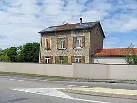 Former train station | |
Location of Saint-Hilaire-de-Brens 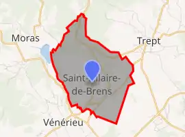 | |
 Saint-Hilaire-de-Brens  Saint-Hilaire-de-Brens | |
| Coordinates: 45°40′22″N 5°17′30″E | |
| Country | France |
| Region | Auvergne-Rhône-Alpes |
| Department | Isère |
| Arrondissement | La Tour-du-Pin |
| Canton | Charvieu-Chavagneux |
| Government | |
| • Mayor (2020–2026) | Laurent Guillet[1] |
| Area 1 | 7.52 km2 (2.90 sq mi) |
| Population | 615 |
| • Density | 82/km2 (210/sq mi) |
| Time zone | UTC+01:00 (CET) |
| • Summer (DST) | UTC+02:00 (CEST) |
| INSEE/Postal code | 38392 /38460 |
| Elevation | 218–387 m (715–1,270 ft) (avg. 367 m or 1,204 ft) |
| 1 French Land Register data, which excludes lakes, ponds, glaciers > 1 km2 (0.386 sq mi or 247 acres) and river estuaries. | |
Population
|
|
See also
References
- "Répertoire national des élus: les maires". data.gouv.fr, Plateforme ouverte des données publiques françaises (in French). 2 December 2020.
- "Populations légales 2019". The National Institute of Statistics and Economic Studies. 29 December 2021.
- INSEE commune file
| Wikimedia Commons has media related to Saint-Hilaire-de-Brens. |
This article is issued from Wikipedia. The text is licensed under Creative Commons - Attribution - Sharealike. Additional terms may apply for the media files.