Saint-Baudille-de-la-Tour
Saint-Baudille-de-la-Tour (French pronunciation: [sɛ̃ bodij də la tuʁ], literally Saint-Baudille of La Tour) is a commune in the Isère department in southeastern France.[3]
Saint-Baudille-de-la-Tour | |
|---|---|
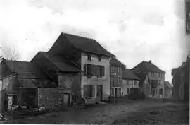 Saint-Baudille de-la-Tour in 1907 | |
Location of Saint-Baudille-de-la-Tour 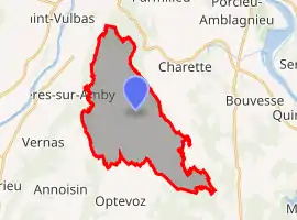 | |
 Saint-Baudille-de-la-Tour  Saint-Baudille-de-la-Tour | |
| Coordinates: 45°47′26″N 5°20′21″E | |
| Country | France |
| Region | Auvergne-Rhône-Alpes |
| Department | Isère |
| Arrondissement | La Tour-du-Pin |
| Canton | Charvieu-Chavagneux |
| Government | |
| • Mayor (2020–2026) | Denis Thollon[1] |
| Area 1 | 21.76 km2 (8.40 sq mi) |
| Population | 814 |
| • Density | 37/km2 (97/sq mi) |
| Time zone | UTC+01:00 (CET) |
| • Summer (DST) | UTC+02:00 (CEST) |
| INSEE/Postal code | 38365 /38118 |
| Elevation | 230–404 m (755–1,325 ft) (avg. 354 m or 1,161 ft) |
| 1 French Land Register data, which excludes lakes, ponds, glaciers > 1 km2 (0.386 sq mi or 247 acres) and river estuaries. | |
Population
|
|
See also
References
| Wikimedia Commons has media related to Saint-Baudille-de-la-Tour. |
- "Répertoire national des élus: les maires". data.gouv.fr, Plateforme ouverte des données publiques françaises (in French). 2 December 2020.
- "Populations légales 2019". The National Institute of Statistics and Economic Studies. 29 December 2021.
- INSEE commune file
This article is issued from Wikipedia. The text is licensed under Creative Commons - Attribution - Sharealike. Additional terms may apply for the media files.