Saint-Appolinard, Isère
Saint-Appolinard (French pronunciation: [sɛ̃.t‿apɔlinaʁ]) is a commune in the Isère department in southeastern France.[3]
Saint-Appolinard | |
|---|---|
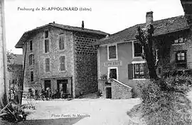 Saint-Appolinard in the early 20th century | |
Location of Saint-Appolinard 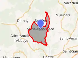 | |
 Saint-Appolinard  Saint-Appolinard | |
| Coordinates: 45°11′23″N 5°15′47″E | |
| Country | France |
| Region | Auvergne-Rhône-Alpes |
| Department | Isère |
| Arrondissement | Grenoble |
| Canton | Le Sud Grésivaudan |
| Government | |
| • Mayor (2020–2026) | Daniel Ferlay[1] |
| Area 1 | 10.76 km2 (4.15 sq mi) |
| Population | 414 |
| • Density | 38/km2 (100/sq mi) |
| Time zone | UTC+01:00 (CET) |
| • Summer (DST) | UTC+02:00 (CEST) |
| INSEE/Postal code | 38360 /38160 |
| Elevation | 329–643 m (1,079–2,110 ft) (avg. 380 m or 1,250 ft) |
| 1 French Land Register data, which excludes lakes, ponds, glaciers > 1 km2 (0.386 sq mi or 247 acres) and river estuaries. | |
Population
|
|
See also
References
- "Répertoire national des élus: les maires". data.gouv.fr, Plateforme ouverte des données publiques françaises (in French). 2 December 2020.
- "Populations légales 2019". The National Institute of Statistics and Economic Studies. 29 December 2021.
- INSEE commune file
| Wikimedia Commons has media related to Saint-Appolinard (Isère). |
This article is issued from Wikipedia. The text is licensed under Creative Commons - Attribution - Sharealike. Additional terms may apply for the media files.