Sage Creek Colony, Montana
Sage Creek Colony is a Hutterite community[3] and census-designated place (CDP) in Liberty County, Montana, United States. It is in the northern part of the county, 33 miles (53 km) north of Chester, the county seat, and 5 miles (8 km) south of the Canadian border.
Sage Creek Colony, Montana | |
|---|---|
 Sage Creek Colony  Sage Creek Colony | |
| Coordinates: 48°55′45″N 110°58′23″W | |
| Country | United States |
| State | Montana |
| County | Liberty |
| Area | |
| • Total | 0.24 sq mi (0.61 km2) |
| • Land | 0.24 sq mi (0.61 km2) |
| • Water | 0.0 sq mi (0.0 km2) |
| Elevation | 3,455 ft (1,053 m) |
| Time zone | UTC-7 (Mountain (MST)) |
| • Summer (DST) | UTC-6 (MDT) |
| ZIP Code | 59522 (Chester) |
| Area code(s) | 406 |
| FIPS code | 30-65160 |
| GNIS feature ID | 2804309[2] |
The community was first listed as a CDP prior to the 2020 census.[2]
References
- "2020 U.S. Gazetteer Files – Montana". United States Census Bureau. Retrieved June 11, 2021.
- "Sage Creek Colony Census Designated Place". Geographic Names Information System. United States Geological Survey.
- Morton, Claudette, ed. (2010). Essential Understandings of Montana Hutterites: A Resource for Educators and Students (PDF). Montana Office of Public Instruction. p. 2. Retrieved June 11, 2021.
Municipalities and communities of Liberty County, Montana, United States | ||
|---|---|---|
| Town | 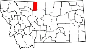 Liberty County map | |
| CDPs | ||
| Unincorporated communities | ||
| Indian reservation | ||
| Footnotes | ‡This populated place also has portions in an adjacent county or counties | |
| ||
This article is issued from Wikipedia. The text is licensed under Creative Commons - Attribution - Sharealike. Additional terms may apply for the media files.