Roquebrune-sur-Argens
Roquebrune-sur-Argens (French pronunciation: [ʁɔkəbʁyn syʁ‿aʁʒɛ̃s]; Occitan: Ròcabruna d'Argenç) is a commune in the Var department and the Provence-Alpes-Côte d'Azur region, southeastern France.
Roquebrune-sur-Argens | |
|---|---|
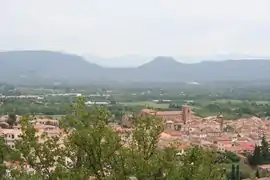 A view of Roquebrune-sur-Argens, from the south-west | |
.svg.png.webp) Coat of arms | |
Location of Roquebrune-sur-Argens 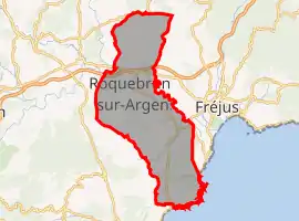 | |
 Roquebrune-sur-Argens  Roquebrune-sur-Argens | |
| Coordinates: 43°26′N 6°38′E | |
| Country | France |
| Region | Provence-Alpes-Côte d'Azur |
| Department | Var |
| Arrondissement | Draguignan |
| Canton | Roquebrune-sur-Argens |
| Intercommunality | Estérel Côte d'Azur Agglomération |
| Government | |
| • Mayor (2020–2026) | Jean Cayron[1] |
| Area 1 | 106.10 km2 (40.97 sq mi) |
| Population | 14,937 |
| • Density | 140/km2 (360/sq mi) |
| Time zone | UTC+01:00 (CET) |
| • Summer (DST) | UTC+02:00 (CEST) |
| INSEE/Postal code | 83107 /83520 |
| Elevation | 1–373 m (3.3–1,223.8 ft) (avg. 13 m or 43 ft) |
| 1 French Land Register data, which excludes lakes, ponds, glaciers > 1 km2 (0.386 sq mi or 247 acres) and river estuaries. | |
It lies not far from the cities of Draguignan and Fréjus. It consists of three smaller villages: the village of Roquebrune-sur-Argens, La Bouverie and Les Issambres. It is home to the French National Water Ski Training Site.
History
The history of the oldest part of the village of Roquebrune sur Argens began around 983. However, signs of human beings, from the "Bouverian culture", dating from pre-history, were found in caves near La Bouverie.
Economy
- Tourism
- Vineyards and horticulture
- Harbour (with a maritime link to Saint-Tropez harbour)
- Two industrial areas
- National Water Skiing Centre
Sites
- The 1000-old village, with many chapels.
- A 2000-year-old fishpond
- Local museum of history
- Le Blavet gorge
Notable people
- Xavier Dupont de Ligonnès, suspected murderer of a family in Nantes
References
- "Municipales à Roquebrune-sur-Argens dans le Var : Jean Cayron (DVC) élu maire" (in French). FranceInfo. 28 June 2020. Retrieved 16 August 2020.
- "Populations légales 2019". The National Institute of Statistics and Economic Studies. 29 December 2021.
External links
Localisation on Var's map
| Wikimedia Commons has media related to Roquebrune-sur-Argens. |
This article is issued from Wikipedia. The text is licensed under Creative Commons - Attribution - Sharealike. Additional terms may apply for the media files.