Rodney ward
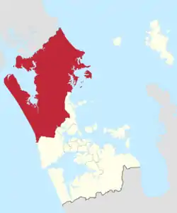
Rodney Ward is a local government area in the northernmost part of New Zealand's Auckland Region, created along with the Auckland Council in 2010.[3] The area was previously part of Rodney District; it does not include the Hibiscus Coast, which was also part of Rodney District but is now in Albany ward. The Rodney Local Board area has the same boundaries as Rodney Ward.
Rodney Ward | |
|---|---|
 | |
| Country | New Zealand |
| Island | North Island |
| Region | Auckland Region |
| Area | |
| • Land | 2,275.08 km2 (878.41 sq mi) |
| Population (June 2021)[2] | |
| • Total | 76,700 |
| Extent | Muriwai Beach to the Kowhai Coast; Helensville and Kumeu to Wellsford and Kawau Island |
Location
Rodney stretches from the spectacular black volcanic sand beaches of Muriwai in the west to the white sands and islands of the Kowhai Coast in the east. The area includes a number of regional parks or areas of special interest. North of Orewa are the coastal Wenderholm, Mahurangi and Tawharanui Regional Parks. Cape Rodney-Okakari Point Marine Reserve, which surrounds Te Hāwere-a-Maki / Goat Island, was New Zealand's first marine reserve, officially opened in 1977. It covers a coastline of about 5 km (3 mi), extends out in sea by 800 m, and encompasses 5 km2 (2 sq mi), inside which all marine life is protected.
Towns in the south of the ward are becoming dormitory districts for Auckland, enjoying improved access by motorway. Further north, communities are more rural. Some have become famous for particular activities such as Puhoi and its cheese factory. Warkworth is a good base to explore the Kowhai Coast, which includes historic Kawau Island, the home of New Zealand's former Governor Sir George Grey, where Mansion House is now a museum.
The dominant feature of the western side of Rodney is Kaipara Harbour, the largest enclosed harbour in the Southern Hemisphere, with a perimeter of about 3,000 km (1,864 mi). The area was once famous for its kauri timber mills.
Kumeu, Matakana and Huapai are becoming well known for their wineries, a number of which provide sampling, cellar-door sales, and restaurants.
Population
Rodney ward covers 2,275.08 km2 (878.41 sq mi)[1] and had an estimated population of 76,700 as of June 2021,[2] with a population density of 34 people per km2.
| Year | Pop. | ±% p.a. |
|---|---|---|
| 2006 | 49,359 | — |
| 2013 | 54,882 | +1.53% |
| 2018 | 66,417 | +3.89% |
| Source: [4] | ||
Rodney ward had a population of 66,417 at the 2018 New Zealand census, an increase of 11,535 people (21.0%) since the 2013 census, and an increase of 17,058 people (34.6%) since the 2006 census. There were 22,761 households. There were 33,123 males and 33,294 females, giving a sex ratio of 0.99 males per female. The median age was 42.2 years (compared with 37.4 years nationally), with 13,251 people (20.0%) aged under 15 years, 10,746 (16.2%) aged 15 to 29, 31,323 (47.2%) aged 30 to 64, and 11,094 (16.7%) aged 65 or older.
Ethnicities were 88.9% European/Pākehā, 11.4% Māori, 3.5% Pacific peoples, 5.7% Asian, and 1.9% other ethnicities (totals add to more than 100% since people could identify with multiple ethnicities).
The proportion of people born overseas was 23.3%, compared with 27.1% nationally.
Although some people objected to giving their religion, 57.7% had no religion, 31.2% were Christian, 0.8% were Hindu, 0.2% were Muslim, 0.5% were Buddhist and 2.6% had other religions.
Of those at least 15 years old, 11,238 (21.1%) people had a bachelor or higher degree, and 8,058 (15.2%) people had no formal qualifications. The median income was $36,500, compared with $31,800 nationally. 12,027 people (22.6%) earned over $70,000 compared to 17.2% nationally. The employment status of those at least 15 was that 27,102 (51.0%) people were employed full-time, 8,988 (16.9%) were part-time, and 1,296 (2.4%) were unemployed.[4]
Governance
| Rodney Ward councillors of Auckland | |
|---|---|
Incumbent Greg Sayers | |
| Term length | Three years |
| Inaugural holder | Penny Webster |
| Formation | 1 November 2010 |
| Website | www.aucklandcouncil.govt.nz |
Rodney Ward is one of the 13 wards of Auckland Council and is governed by the Mayor of Auckland. It has one directly elected councillor who sits on the Auckland Council. The councillor has oversight over Rodney Local Board.
| Election | Councillor elected | Affiliation | Votes | Notes |
|---|---|---|---|---|
| 2010 | Penny Webster | Independent | 8645 | |
| 2013 | Penny Webster | Independent | 8587 | |
| 2016[5] | Greg Sayers | Independent | 9252[6] | |
| 2019[7] | Greg Sayers | Independent | - | Re-elected unopposed |
References
- "ArcGIS Web Application". statsnz.maps.arcgis.com. Retrieved 24 February 2022.
- "Population estimate tables - NZ.Stat". Statistics New Zealand. Retrieved 22 October 2021.
- "Idiot's guide to the Super City". The New Zealand Herald. 14 May 2010. Retrieved 5 November 2011.
- "Statistical area 1 dataset for 2018 Census". Statistics New Zealand. March 2020. Rodney Ward (07601).
- "Local body election nominations close". Radio New Zealand. 2016-08-12. Retrieved 6 December 2017.
- "Ward councillors – North Shore Ward confirmed" (PDF). Auckland Council. 2016. Retrieved 6 December 2017.
- "Auckland local board election results: Some wards too close to call". Stuff.co.nz. 12 October 2019. Retrieved 18 October 2019.