Rivière-Mouchalagane, Quebec
Rivière-Mouchalagane is an unorganized territory in the Côte-Nord region of Quebec, Canada, part of Caniapiscau Regional County Municipality.
Rivière-Mouchalagane | |
|---|---|
 | |
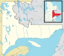
 Rivière-Mouchalagane Location in Côte-Nord Region of Quebec. | |
| Coordinates: 52°20′N 68°30′W[1] | |
| Country | |
| Province | |
| Region | Côte-Nord |
| RCM | Caniapiscau |
| Constituted | January 1, 1986 |
| Government | |
| • Federal riding | Manicouagan |
| • Prov. riding | Duplessis |
| Area | |
| • Total | 34,645.10 km2 (13,376.55 sq mi) |
| • Land | 30,999.10 km2 (11,968.82 sq mi) |
| Population (2021)[3] | |
| • Total | 15 |
| • Density | 0.0/km2 (0/sq mi) |
| • Pop 2016-2021 | |
| • Dwellings | 40 |
| Time zone | UTC-5 (EST) |
| • Summer (DST) | UTC-4 (EDT) |
| Highways | |
The ghost town of Gagnon is located in the territory along Quebec Route 389 which also provides access to Fermont and Labrador City.
The eponymous Mouchalagane River has its source in Sommet and Itomamis Lakes, and flows for 132 kilometres (82 mi) to the south, after which it drains into the Manicouagan Reservoir. Before the formation of this reservoir, the river would flow into Lake Mouchalagane.[4]
References
- Reference number 149768 of the Commission de toponymie du Québec (in French)
- "Rivière-Mouchalagane". Répertoire des municipalités (in French). Ministère des Affaires municipales, des Régions et de l'Occupation du territoire. Retrieved 2012-05-11.
- "Rivière-Mouchalagane census profile". 2021 Census of Population. Statistics Canada. Retrieved 2022-03-22.
- "Rivière Mouchalagane" (in French). Commission de toponymie du Québec. Retrieved 2009-10-06.
This article is issued from Wikipedia. The text is licensed under Creative Commons - Attribution - Sharealike. Additional terms may apply for the media files.