Regnière-Écluse
Regnière-Écluse is a commune in the Somme department in Hauts-de-France in northern France.
Regnière-Écluse | |
|---|---|
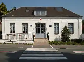 Town hall. | |
Location of Regnière-Écluse 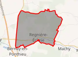 | |
 Regnière-Écluse  Regnière-Écluse | |
| Coordinates: 50°16′54″N 1°46′05″E | |
| Country | France |
| Region | Hauts-de-France |
| Department | Somme |
| Arrondissement | Abbeville |
| Canton | Rue |
| Intercommunality | CC Ponthieu-Marquenterre |
| Government | |
| • Mayor (2020–2026) | Patrick Bost |
| Area 1 | 9.54 km2 (3.68 sq mi) |
| Population | 123 |
| • Density | 13/km2 (33/sq mi) |
| Time zone | UTC+01:00 (CET) |
| • Summer (DST) | UTC+02:00 (CEST) |
| INSEE/Postal code | 80665 /80120 |
| Elevation | 5–60 m (16–197 ft) (avg. 17 m or 56 ft) |
| 1 French Land Register data, which excludes lakes, ponds, glaciers > 1 km2 (0.386 sq mi or 247 acres) and river estuaries. | |
Geography
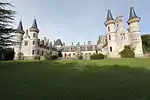
Castle in Regnière.
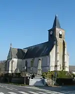
Church in Regnière and world war memorial.
The commune is situated some 14 miles (23 km) north of Abbeville, on the D938 road and surrounded by the forest of Crécy-en-Ponthieu.
Population
| Year | Pop. | ±% p.a. |
|---|---|---|
| 1968 | 157 | — |
| 1975 | 154 | −0.28% |
| 1982 | 120 | −3.50% |
| 1990 | 125 | +0.51% |
| 1999 | 122 | −0.27% |
| 2007 | 136 | +1.37% |
| 2012 | 133 | −0.45% |
| 2017 | 126 | −1.08% |
| Source: INSEE[2] | ||
See also
This article is issued from Wikipedia. The text is licensed under Creative Commons - Attribution - Sharealike. Additional terms may apply for the media files.