Recife metropolitan area
Recife Metropolitan Area, officially the Metropolitan Region of Recife (Brazilian Portuguese: Região Metropolitana do Recife (RMR), or Grande Recife) is a major metropolitan area in Northeast Brazil with a population of 4.02 million as of 2020,[1] centered on the state capital of Recife, Pernambuco. In 2017, it was ranked as the 8th largest Metropolitan Region nationally.[2]
Grande Recife
Região Metropolitana do Recife (RMR) | |
|---|---|
Metro Area | |
| Metropolitan Region of Recife | |
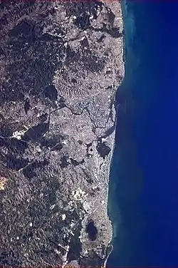 The RMR seen from the International Space Station | |
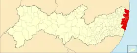 The Metropolitan Region in Pernambuco (including the former member of Goiana) | |
| Country | |
| Region | Northeast |
| State | |
| Metropolitan Area established | June 8, 1973 |
| Recife as Capital | 1827 |
| Area | |
| • Metro | 2,764.26 km2 (1,067.29 sq mi) |
| Population (2010) | |
| • Metro Area | 3,690,547 |
| • Estimate (2020) | 4,023,725 |
| Time zone | UTC-3 (BRT) |
| HDI (2000) | 0.734 – high |
The Brazilian Institute of Geography and Statistics (IBGE) defines the region as a "metropolis" in its Area of Influence surveys, in terms of economic and social importance.[3] The region's area of influence covers a large part of Northeast Brazil, including the entire states of Alagoas, Paraíba, and Pernambuco, in addition to portions of Bahia, Ceará, Maranhão, Piauí, Rio Grande do Norte, and Sergipe. Within this area of influence are the smaller cities of Natal, João Pessoa, Maceió, and Aracaju.
Municipalities
The Metropolitan Region is defined in federal[4] and state[5] legislation as consisting of 14 municipalities. Goiana was formerly a part, but left in March 2020.[6][7] The Immediate Geographic Region (formerly termed microregion) around Recife defined by the IBGE[8] encompasses additional outlying municipalities.
| Municipality | Area as of 2020 (km²)[9] | Population (2010 census)[10] | Population (2020 estimate)[1] | GDP (2017)[11] in thousand R$ | GDP per capita (2017)[11] in R$ |
|---|---|---|---|---|---|
| Abreu e Lima | 126.384 | 94 429 | 100 346 | 2 003 665 | 20 164.90 |
| Araçoiaba | 96.360 | 18 156 | 20 733 | 139 026 | 6 859.40 |
| Cabo de Santo Agostinho | 445.343 | 185 025 | 208 944 | 9 964 401 | 46 689.25 |
| Camaragibe | 51.321 | 144 466 | 158 899 | 1 757 192 | 11 238.05 |
| Igarassu | 306.879 | 102 021 | 118 370 | 2 479 117 | 21 483.19 |
| Ilha de Itamaracá | 66.146 | 21 884 | 26 672 | 239 399 | 9 289.99 |
| Ipojuca | 521.801 | 80 637 | 97 669 | 10 879 739 | 115 089.32 |
| Itapissuma | 73.968 | 23 769 | 26 900 | 1 398 050 | 53 081.09 |
| Jaboatão dos Guararapes | 258.724 | 644 620 | 706 867 | 13 545 569 | 19 463.25 |
| Moreno | 196.073 | 56 696 | 63 294 | 682 663 | 10 989.60 |
| Olinda | 41.300 | 377 779 | 393 115 | 5 438 691 | 13 917.85 |
| Paulista | 96.932 | 300 466 | 334 376 | 4 019 150 | 12 240.33 |
| Recife | 218.843 | 1 537 704 | 1 653 461 | 51 859 618 | 31 743.72 |
| São Lourenço da Mata | 264.190 | 102 895 | 114 079 | 1 107 308 | 9 877.95 |
| Total | 2 764.26 | 3 690 547 | 4 023 725 | 105 513 588 | - |
Transport
Airport
Guararapes – Gilberto Freyre International Airport serves the area, and has domestic and international flights.

Metro
Since 1998, an extension to the Recife Metro is being built. When ready, it will become the second largest in Brazil, after São Paulo.[14]
This system also integrates with several bus lines connected to the bus/metro[15] integration terminals, such as Barro and Joana Bezerra stations. It is possible to ride the metro and the connected bus line by purchasing one ticket only. Since March 2009, Recife Metro has finished one more phase of expansion. The system counts now has 28 stations (11 integrated with buses) and is 39.5 kilometers long.
Bus
Buses transport almost two million passengers daily.[16]
References
- "Population Estimates | IBGE". www.ibge.gov.br. Brazilian Institute of Geography and Statistics. Retrieved 2021-04-01.
{{cite web}}: CS1 maint: url-status (link) - ""Tabela 4: POPULAÇÃO DAS REGIÕES METROPOLITANAS, REGIÕES INTEGRADAS DE DESENVOLVIMENTO E AGLOMERAÇÕES URBANAS COM MAIS DE UM MILHÃO DE HABITANTES"". IBGE. Brazilian Institute of Geography and Statistics.
{{cite web}}: CS1 maint: url-status (link) - "Areas of Influence of Cities | IBGE". www.ibge.gov.br. Brazilian Institute of Geography and Statistics. Retrieved 2021-04-01.
{{cite web}}: CS1 maint: url-status (link) - "Lei Complementar Federal do Brasil 14 de 1973 - Wikisource". pt.wikisource.org (in Portuguese). Retrieved 2021-04-01.
- "Alepe Legis - Portal da Legislação Estadual de Pernambuco". Alepe Legis - Portal da Legislação Estadual (Legislative Assembly of the State of Pernambuco) (in Brazilian Portuguese). Retrieved 2021-04-01.
{{cite web}}: CS1 maint: url-status (link) - "Saída de Goiana da RMR é aprovada pela Alepe". www.folhape.com.br (in Brazilian Portuguese). Retrieved 2021-04-01.
- "IBGE reintegra município de Goiana à Zona da Mata de Pernambuco". G1 (in Brazilian Portuguese). Retrieved 2021-04-01.
- "Regiões Geográficas". www.ibge.gov.br. Brazilian Institute of Geography and Statistics. Geographic Regions in the State of Pernambuco. Retrieved 2021-04-01.
{{cite web}}: CS1 maint: url-status (link) - "Territorial Areas | IBGE". www.ibge.gov.br. Brazilian Institute of Geography and Statistics. Retrieved 2021-04-01.
{{cite web}}: CS1 maint: url-status (link) - "Population Census | IBGE". www.ibge.gov.br. Brazilian Institute of Geography and Statistics. Table 3.1. Retrieved 2021-04-01.
{{cite web}}: CS1 maint: url-status (link) - "Gross Domestic Product of Municipalities | IBGE". www.ibge.gov.br. Brazilian Institute of Geography and Statistics. 2010-2018 base. Retrieved 2021-04-01.
{{cite web}}: CS1 maint: url-status (link) - Rafael. "O que fazer em Recife? Dicas Para Você Aproveitar Recife" (in European Portuguese). Retrieved 2021-04-05.
- Qual é o maior metrô do Brasil? (in Portuguese)
- Recife Metro (in Portuguese). Recife, Brazil: Diário de Pernambuco. 2006. ISBN 85-240-3919-1. Archived from the original (PDF) on 2008-02-02. Retrieved 2007-07-18.
- Recife Metro (in Portuguese). Recife, Brazil: CBTU. 2006. ISBN 85-240-3919-1. Archived from the original (PDF) on 2008-02-02. Retrieved 2007-07-18.
- http://jc.uol.com.br/2008/06/27/not_172583.php%5B%5D