Rajsamand district
Rajsamand District is a district of the state of Rajasthan in western India. The town of Rajnagar is the district headquarters. The district was constituted on 10 April 1991 from Udaipur district by carving out 7 entire tehsils - Bhim, Deogarh, Amet, Kumbhalgarh, Rajsamand, Nathdwara, and Railmagra.[1]
Rajsamand district | |
|---|---|
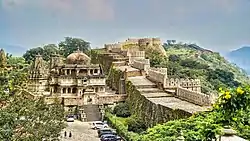  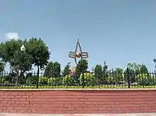 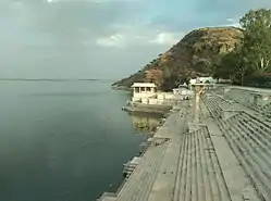 From top left to right: Wall at Kumbalgarh Fort, Statue of Maharana Pratap at Haldighati, Third Eye Circle in Nathdwara, Rajsamand Lake | |
.svg.png.webp) | |
| Coordinates: 25°04′N 73°52′E | |
| Country | |
| State | Rajasthan |
| Division | Udaipur |
| Established | 10 April 1991 |
| Founded by | Rana Raj Singh |
| Named for | Rajsamand lake |
| Area | |
| • Total | 4,550.93 km2 (1,757.12 sq mi) |
| • Rank | 19 |
| Population (2011) | |
| • Total | 1,156,597 |
| • Density | 217/km2 (560/sq mi) |
| Languages | |
| • Official | Hindi |
| • Regional | Mewari |
| Time zone | UTC+5:30 (IST) |
| PIN | 313324/26 |
| Telephone code | 02952 |
| Vehicle registration | RJ-30 |
| Lok Sabha constituency | Rajsamand (Lok Sabha constituency) |
| Nearest city | Udaipur, Chittorgarh, Bhilwara, Ajmer |
| Avg. annual temperature | 22.5 °C (72.5 °F) |
| Avg. summer temperature | 45 °C (113 °F) |
| Avg. winter temperature | 00 °C (32 °F) |
| Website | rajsamand |
Geography
The district has an area of 4,768 km2. The Aravalli Range forms the northwestern boundary of the district, across which lies Pali District. Ajmer District lies to the north, Bhilwara District to the northeast and east, Chittorgarh District to the southeast, and Udaipur District to the south. The district lies in the watershed of the Banas River and its tributaries. Some other rivers are: Ari, Gomati, Chandra and Bhoga.
Demographics
According to the 2011 census Rajsamand district has a population of 1,156,597,[3] roughly equal to the nation of Timor-Leste[4] or the US state of Rhode Island.[5] This gives it a ranking of 405th in India (out of a total of 640).[3] The district has a population density of 302 inhabitants per square kilometre (780/sq mi) .[3] Its population growth rate over the decade 2001-2011 was 17.35%.[3] Rajsamand has a sex ratio of 988 females for every 1000 males,[3] and a literacy rate of 63.93%. Scheduled Castes and Scheduled Tribes make up 12.8% and 13.9% of the population respectively.[3]
Languages
Mewari, Rajasthani, Hindi.
Languages in Rajsamand District (2011)[6]
| Year | Pop. | ±% p.a. |
|---|---|---|
| 1901 | 187,692 | — |
| 1911 | 232,110 | +2.15% |
| 1921 | 246,483 | +0.60% |
| 1931 | 282,066 | +1.36% |
| 1941 | 336,384 | +1.78% |
| 1951 | 395,465 | +1.63% |
| 1961 | 470,115 | +1.74% |
| 1971 | 553,189 | +1.64% |
| 1981 | 693,358 | +2.28% |
| 1991 | 819,014 | +1.68% |
| 2001 | 982,523 | +1.84% |
| 2011 | 1,156,597 | +1.64% |
| source:[7] | ||
Places to interest
Rajsamand district had lot of natural and historical places to visit.
References
- District Census Handbook Rajsamand PART XII-A (PDF). Directorate of Census Operations. 2011. Retrieved 30 March 2019.
- "C-1 Population By Religious Community (Rajasthan)". Census India.
- "District Census 2011". Census2011.co.in. 2011. Retrieved 30 September 2011.
- US Directorate of Intelligence. "Country Comparison:Population". Retrieved 1 October 2011.
Timor-Leste 1,177,834, July 2011 est.
- "2010 Resident Population Data". U. S. Census Bureau. Retrieved 30 September 2011.
Rhode Island 1,052,567
- "Archived copy". Archived from the original on 15 August 2018. Retrieved 26 April 2019.
{{cite web}}: CS1 maint: archived copy as title (link) - Decadal Variation In Population Since 1901
External links
| Wikimedia Commons has media related to Rajsamand district. |
Places adjacent to Rajsamand district | ||||||||||||||||
|---|---|---|---|---|---|---|---|---|---|---|---|---|---|---|---|---|
| ||||||||||||||||
| Outline |  | ||||||||||||||
|---|---|---|---|---|---|---|---|---|---|---|---|---|---|---|---|
| Governance | |||||||||||||||
| Divisions and districts |
| ||||||||||||||
| Major cities | |||||||||||||||
| Related templates |
| ||||||||||||||