R328 (South Africa)
The R328 is a Regional Route in South Africa that connects Mossel Bay in the south to Prince Albert Road in the north via Prince Albert, and Oudtshoorn.[1]
 | ||||
|---|---|---|---|---|
| Route information | ||||
| Length | 74.5 km (46.3 mi) | |||
| Location | ||||
| Country | South Africa | |||
| Highway system | ||||
| ||||
Route
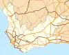
Its northern origin at the N1 at Prince Albert Road. It heads south-east to Prince Albert. Just before the town, it intersects with the southern origin of the R353. Leaving Prince Albert, it heads south. It intersects with the west origin of the R407 as it approaches the Swartberg Mountains. After the intersection it enters the Swartberg Pass. On the other side, it veers east-south-east. Just before it again heads south, it gives off a short northern road to the Cango Caves. It then heads south into the Schoemanspoort Pass. On the other side, it continues south to Oudtshoorn. At Oudtshoorn, it meets an intersection with the N12 and R62. Along with the R62, it is then signed as the western road (the southern becomes the N12/R62 and the eastern the N12). Just outside the town, the route diverges from the R62 and continues in a direction just west of south. It crosses the Outeniqua mountains at Robinson Pass to reach its terminus at the N2.
External links
References
- "RDDA SOUTH AFRICAN NUMBERED ROUTE DESCRIPTION AND DESTINATION ANALYSIS". NATIONAL DEPARTMENT OF TRANSPORT. May 2012. Retrieved 25 March 2021.
{{cite web}}: CS1 maint: url-status (link)