Queensborough Bridge
Queensborough Bridge is a highway bridge in New Westminster, British Columbia. It was built in 1960 by John Laing and Son (Canada) for the City of New Westminster and cost $4 million (equivalent to $37.5 million in 2022). The bridge spans the north arm of the Fraser River for road access from the main part of New Westminster to the suburb of Queensborough at the east end of Lulu Island, giving the bridge its name.
Queensborough Bridge | |
|---|---|
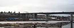 The Queensborough Bridge seen from the south side | |
| Coordinates | 49.196415°N 122.947183°W |
| Carries | Four lanes of British Columbia Highway 91A, pedestrians and bicycles |
| Crosses | North Arm Fraser River |
| Locale | New Westminster |
| Maintained by | British Columbia Ministry of Transportation and Infrastructure |
| Characteristics | |
| Design | Arch bridge |
| Total length | 924 m |
| History | |
| Designer | Phillips Barrat and Partners |
| Constructed by | John Laing and Son (Canada Ltd.) |
| Construction cost | $4 Million ($37.5 million in 2022) |
| Opened | 26 August, 1960 [1] |
| Statistics | |
| Daily traffic | 81,000 (July 2021)[2] |
| Location | |
 | |
It has since become a part of Highway 91A feeder to Highway 91 to the south. The Queensborough was a toll bridge costing 25 cents to cross until the bridge was bought by the provincial government in November 1966. In 2009, the interchange with Marine Way and Stewardson Way saw improving, including the trumpet loop being flipped to its current rotation. [3] [4] [5]
See also
| Wikimedia Commons has media related to Queensborough Bridge. |
References
- "New Bridge Queensborough Replaces 51 Year-Old Span". Vancouver Sun. New Westminster. 26 August 1960. Retrieved 19 Feb 2022.
- B.C. Ministry of Transportation and Infrastructure (13 Oct 2021). "Monthly Volume Calender - Queensborough South P-16-287NS - NY" (PDF).
- B.C. Ministry of Transportation (3 April 2009). "BORDER INFRASTRUCTURE PROJECTS COMPLETE". Retrieved 19 Feb 2022.
- B.C. Ministry of Transportation (3 April 2009). "OVERVIEW OF THE CANADA-BC BORDER INFRASTRUCTURE PROGRAM". Retrieved 19 Feb 2022.
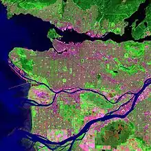
- MAXAR Technologies (2 July 2004). Queensborough Bridge, New Westminster, B.C. (Interactive Satellite Photography) (Satellite Photography). New Westminster, British Columbia: Google via Google Earth Pro. Retrieved 19 Feb 2022.