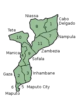
Provinces of Mozambique
Mozambique is divided into 10 provinces (províncias) and 1 capital city (cidade) with provincial status:
| Map Key | Province | Capital | Area (km2) [1] |
Population (2007 census) |
Population (2017 census) |
Population approximately equal | Region |
|---|---|---|---|---|---|---|---|
| 1 | Cabo Delgado | Pemba | 86,625 | 1,606,568 | 2,333,278 | North | |
| 2 | Gaza | Xai-Xai | 75,709 | 1,228,514 | 1,446,654 | South | |
| 3 | Inhambane | Inhambane | 68,615 | 1,271,818 | 1,496,824 | South | |
| 4 | Manica | Chimoio | 61,661 | 1,412,248 | 1,911,237 | Central | |
| 5 | Maputo City | - | 347 | 1,094,628 | 1,101,170 | South | |
| 6 | Maputo | Matola | 26,011 | 1,205,709 | 2,507,098 | South | |
| 7 | Nampula | Nampula | 81,606 | 3,985,613 | 6,102,867 | North | |
| 8 | Niassa | Lichinga | 129,056 | 1,170,783 | 1,865,976 | North | |
| 9 | Sofala | Beira | 68,018 | 1,642,920 | 2,221,803 | Central | |
| 10 | Tete | Tete | 100,724 | 1,783,967 | 2,764,169 | Central | |
| 11 | Zambezia | Quelimane | 105,008 | 3,849,455 | 5,110,787 | North | |
| Provinces of Mozambique Províncias de Moçambique (Portuguese) | |
|---|---|
 | |
| Category | Unitary state |
| Location | Mozambique |
| Number | 11 Provinces |
| Populations | 1,446,654 (Gaza) – 6,102,867 (Nampula) |
| Areas | 347 km2 (134 sq mi) (Maputo City) – 129,056 km2 (49,829 sq mi) (Niassa) |
| Government |
|
| Subdivisions | |
 |
|---|
|
|
See also
External links
- Provinces of Mozambique, Statoids.com
References
- Mozambique at GeoHive Archived 2014-09-24 at the Wayback Machine
This article is issued from Wikipedia. The text is licensed under Creative Commons - Attribution - Sharealike. Additional terms may apply for the media files.