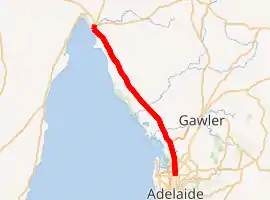
Port Wakefield Road
Port Wakefield Road and Port Wakefield Highway are an important South Australian highway. They connect Adelaide to the Yorke Peninsula, Port Augusta, northern and western South Australia, the Northern Territory and Western Australia. They are designated National Highway A1 and a part of the National Highway. They are named after Port Wakefield, the first government town north of Adelaide. Historically, the whole route was named Port Wakefield Road, however following the opening of the Northern Expressway, the route north of that junction was named Port Wakefield Highway.
Port Wakefield Road | |
|---|---|
 | |
| Coordinates |
|
| General information | |
| Type | Highway |
| Length | 92 km (57 mi) |
| Route number(s) | |
| Former route number |
|
| Major junctions | |
| North end | Port Wakefield, South Australia |
| South end | Gepps Cross, Adelaide |
| Location(s) | |
| Major settlements | Two Wells, Virginia, Cavan, Gepps Cross |
| Highway system | |
Location
Port Wakefield Road branches off of Main North Road at Gepps Cross in the northern suburbs of Adelaide. The route is dual-carriageway for its entire length to Port Wakefield and bypasses all of the small towns along its former route. The original bypass of Port Wakefield is now built up with roadhouses and other businesses, leading to calls to build a new bypass further east.[1]
History
The four-span bridge opened in 1926 over the Gawler railway line at Cavan was replaced with two dual carriageway bridges in 1980.[2] At the same time Virginia and Two Wells were bypassed.[3]
In 2011 an upgrade including road widening of nine kilometres of Port Wakefield Road between Salisbury Highway and Waterloo Corner Road was completed as part of the Northern Expressway project.[4]
In February 2020, the northbound ramp from Port Wakefield Road to the Northern Expressway was closed permanently as part of the final stages of opening the Northern Connector, the project name for the northernmost part of the North–South Motorway, a new freeway west of Port Wakefield Road, connecting the southern end of the Northern Expressway to the northern end of the South Road Superway. Northbound traffic to the Northern Expressway needs to use an earlier entrance to the North–South Motorway or join the Northern Expressway later via Waterloo Corner Road and Heaslip Road.[5]
The contract for detailed design and construction of duplication of the highway through Port Wakefield and grade-separated intersection with the Copper Coast Highway was let in March 2020 to the Port Wakefield to Port Augusta Alliance, a consortium of CPB Contractors, Aurecon and GHD Group. This consortium is also responsible for the duplication of Joy Baluch AM Bridge in Port Augusta.[6][7]
In 2021, the government announced that they'd build an overpass at a notorious traffic spot. [8]
Major intersections
| LGA | Location[9] | km[10] | mi | Destinations | Notes |
|---|---|---|---|---|---|
| Port Adelaide Enfield | Blair Athol–Enfield–Gepps Cross tripoint | 0 | 0.0 | Southern terminus of Port Wakefield Road; continues south as Five-way traffic light intersection | |
| Gepps Cross–Dry Creek boundary | 1.2 | 0.75 | |||
| Salisbury | Cavan | 2.3 | 1.4 | Churchill Road North (west) – Dry Creek Montague Road (east) – Pooraka, Para Vista | |
| Dry Creek–Mawson Lakes boundary | 4.0 | 2.5 | Diamond interchange | ||
| Bolivar–Paralowie | 9.4 | 5.8 | |||
| Waterloo Corner | 13.0 | 8.1 | Waterloo Corner Road – Salisbury, St Kilda | ||
| Playford | 15.7– 17.0 | 9.8– 10.6 | Partial interchange: southbound entrances to Northern Expressway and Northern Connector, no northbound entrances to either | ||
| Virginia, Waterloo Corner | 17.6 | 10.9 | Old Port Wakefield Road – Virginia | ||
| Virginia, Buckland Park | 23 | 14 | Angle Vale Road – Virginia, Angle Vale, Gawler | ||
| Adelaide Plains | Two Wells | 30 | 19 | ||
| Wakefield | Port Wakefield | 87.3 | 54.2 | North Street (west) – Port Wakefield | Northern terminus of Port Wakefield Road; continues north as |
1.000 mi = 1.609 km; 1.000 km = 0.621 mi
| |||||
Towns
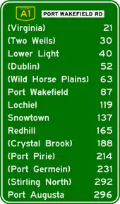
Port Wakefield Road passes through the northern Adelaide Plains. To the west of the road is the coastal fringe of upper Gulf St Vincent, including a number of fishing and holiday villages. To the east is rich cropping and farming land.
The list of towns on or near the road include:
See also
![]() Australian Roads portal
Australian Roads portal
References
- "Mid North and Yorke Peninsula" (PDF). Strategic Infrastructure Plan. Government of South Australia. April 2005. Archived from the original (PDF) on 11 May 2006. Retrieved 3 August 2006.
- Port Wakefield Road Closed The News 4 September 1926 page 8
- Upgrading for Adelaide's northern outlets Australian Transport March 1980 page 19
- "AusLink Projects: Northern Expressway". AusLink. Government of Australia. 14 July 2006. Archived from the original on 7 November 2007. Retrieved 3 August 2006.
- "Northern Expressway on-ramp – closure and detour" (PDF). North-South Corridor Northern Connector Project notification. Department of Planning, Transport & Infrastructure. February 2020. Archived (PDF) from the original on 29 February 2020. Retrieved 29 February 2020.
- "Port Wakefield Overpass and Highway Duplication". Department of Planning, Transport & Infrastructure. Retrieved 9 May 2020.
- McCormack, Michael (1 March 2020). "PORT WAKEFIELD AND JOY BALUCH UPGRADES ARE SIGNED, SEALED AND SOON TO BE DELIVERED" (PDF) (Press release). Retrieved 9 May 2020 – via Department of Planning, Transport & Infrastructure.
- https://m.youtube.com/watch?v=p1CrVPEpeuc
- A.J.Miazzo (16 December 2013). "Naming of State Rural Roads - Mid North" (PDF). Government of South Australia. Rack Plan 869. Archived from the original (PDF) on 4 September 2014. Retrieved 17 November 2016.
- Google (12 June 2014). "Port Wakefield Road" (Map). Google Maps. Google. Retrieved 12 June 2014.
Road infrastructure in South Australia | ||
|---|---|---|
| Expressways |
| |
| Interstate highways | ||
| State highways | ||
| Arterial roads |
| |
| Outback tracks | ||