Port Area, Manila
The Port Area is a district of the city of Manila, Philippines. Post-war developments at the Manila South Harbor eventually paved the way for the migration of people from the different provinces, making it one of the largest urban poor community in the Philippines.
Port Area | |
|---|---|
District of Manila | |
.jpg.webp) Aerial view of Port Area with Customs House | |
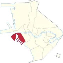 Map of Manila showing the location of Port Area | |
 | |
| Coordinates: 14.588726°N 120.968597°E | |
| Country | Philippines |
| Region | National Capital Region |
| City | Manila |
| District | Part of the 5th district of Manila |
| Population (2020)[1] | |
| • Total | 72,605 |
Barangays
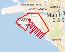
Port Area, Manila is made up of 5 barangays, numbered 649, 650, 651, 652 and 653. Barangay 649 contains the Engineer's Island, now informally known as the Baseco Compound. The Island is regarded as one of the biggest urban poor community in the Philippines.
| Barangay | Population (2020)[1] |
|---|---|
| Barangay 649 | 64,750 |
| Barangay 650 | 5,202 |
| Barangay 651 | 2,556 |
| Barangay 652 | 39 |
| Barangay 653 | 58 |
References
- "Highlights of the Philippine Population 2015 Census of Population". Philippine Statistics Authority. Retrieved July 11, 2017.
External links
 Media related to Port Area, Manila at Wikimedia Commons
 Geographic data related to Port Area, Manila at OpenStreetMap
| Topics |  | |
|---|---|---|
| Government |
| |
| Districts | ||
| Mixed-use developments | ||
| Beaches | ||
| Legislative districts | ||
| ||
This article is issued from Wikipedia. The text is licensed under Creative Commons - Attribution - Sharealike. Additional terms may apply for the media files.