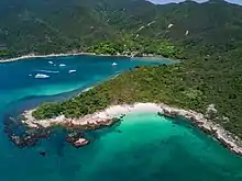
High Island (Hong Kong)
High Island or Leung Shuen Wan Chau (Chinese: 糧船灣洲) is a former island located in the southeast of Sai Kung Peninsula, east of Port Shelter, Kau Sai Chau, Jin Island, Tai Tau Chau, and Bay Islet, north of Town Island, Bluff Island, Basalt Island, Wang Chau, Wong Nai Chau, and Kong Tau Pai, as well as west of Po Pin Chau and Conic Island. High Island historically had an area of 8.511 km² and was the 4th largest island of Hong Kong in 1960.[1] The body of water to the southwest of the former island is called Rocky Harbour or Leung Shuen Wan Hoi (糧船灣海; 'grain ship bay sea').The island is under the jurisdiction of the Sai Kung District.
_02.jpg.webp)

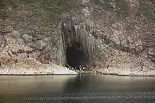
The island is now connected to the peninsula by two dams that enclosed the Kwun Mun Channel (官門海峽), thereby forming the High Island Reservoir. The dams were constructed between 1969 and 1979. The area is part of the Sai Kung East Country Park.[2] The eastern part of High Island is part of the Sai Kung Volcanic Rock Region of the Hong Kong Geopark.
The water body near Leung Shuen Wan is a designated fish culture zone and its shores features several seafood restaurants.[3]
Etymology
Geologically, high islands are islands of volcanic origin. The term can be used to distinguish such islands from low islands, which are formed from sedimentation or the uplifting of coral reefs (which have often formed on sunken volcanos).[4]
Population
There are four villages on High Island, namely: Pak A (北丫), Tung A (東丫), Sha Kiu (沙橋) and Pak Lap (白腊). They are all located along the west coast.[1] In 2006, a few dozen people lived in these four villages, and about 100 people lived in designated fish culture zones.[1] Another settlement, Tai She Wan (大蛇灣) is located further west along the coast.
Geology
High Island features columnar-jointed volcanic tuff. Most of the columns are sub-vertical, straight-sided and parallel. This type of volcanic rock covers a large area around Sai Kung Peninsula in the eastern part of Hong Kong, including High Island Reservoir and Tai Long Wan.
Locations
Tin Hau Temple
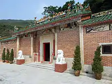
There is a Tin Hau Temple (糧船灣天后宮) on High Island, located between Pak A and Tung A. Built in 1741, it is one of the two temples which have a marine parade to celebrate the Tin Hau Festival (天后誕). The other is the Tin Hau Temple in Tap Mun which has it once every ten years.[5] The Tin Hau Festival at High Island takes place every two years. The religious ceremony lasts six days and the marine parade is held on the eve of Tin Hau's birthday.[1] Other deities including Kwan Tai and Kwun Yam are also worshipped at the temple.[5] The temple was listed as a Grade II historic building in 1996, and as a Grade III historic building in 2010.[6]
Refugee camp
The High Island Detention Centre was a refugee camp built near West Dam of the reservoir for hosting refugees and boat people from Vietnam. The area is now a flat piece of grassland that is grazed by cows. It has a pavilion that leads out of the strip of land.
Transportation
There are public piers in Pak A, Tung A and Sha Kiu, but there is no public ferry service to High Island.[7] Sai Kung Man Yee Road (西貢萬宜路) runs through the northern part of High Island, roughly along High Island Reservoir, from West Dam to East Dam. The 9A minibus route is the only public transportation that can reach the East Dam of the High Island Reservoir, meanwhile urban taxis and new territories taxis are also allowed in Sai Kung Man Yee Road.
References
- Chan, Tin-kuen, Anthony (September 2006). Parade for the queen: safeguarding the intangible heritage of the Tin Hau Sea Ritual in Leung Shuen Wan, Sai Kung (Postgraduate thesis, Master of Science in Conservation). University of Hong Kong.
- "Sai Kung East Country Park". Agriculture, Fisheries and Conservation Department. Retrieved 18 July 2016.
- "Leung Shuen Wan Tin Hau Temple", travelinsaikung.org.hk (archive)
- 《香港九龍兼新界形勢圖》,香港中華書局,1940年
- Antiquities Advisory Board. Historic Building Appraisal. Tin Hau Temple, Leung Shuen Wan
- Antiquities and Monuments Office. List of the Historic Buildings in Building Assessment Archived 2011-12-15 at the Wayback Machine
- Griffiths, Nigel (22 May 2014). "Ultimate guide to High Island". Sai Kung & Clearwater Bay Magazine.
External links
| Wikimedia Commons has media related to High Island, Hong Kong. |
- Delineation of area of existing village Pak A (Sai Kung) for election of resident representative (2019 to 2022)
- Delineation of area of existing village Pak Lap (Sai Kung) for election of resident representative (2019 to 2022)
- Delineation of area of existing village Tai She Wan (Sai Kung) for election of resident representative (2019 to 2022)
- Delineation of area of existing village Tung A (Sai Kung) for election of resident representative (2019 to 2022) (includes Sha Kiu)
- High Island: Internationally rare acidic polygonal volcanic rock columns
- Antiquities Advisory Board. Pictures of Tin Hau Temple, Leung Shuen Wan