Ombai Strait
Ombai Strait (Indonesian: Selat Ombai, Portuguese: Estreito de Ombai, Tetum: Estreitu Ombai) is an international strait in Southeast Asia. It separates the Alor Archipelago from the islands of Wetar, Atauro, and Timor in the Lesser Sunda Islands. The strait is also the western portion of a pair of international straits, the other one being Wetar Strait; the two straits combine to link the Pacific Ocean with the Indian Ocean.
| Ombai Strait | |
|---|---|
.jpg.webp) Ombai Strait from Ai Pelo, East Timor, in 2018 | |
 Ombai Strait | |
 | |
| Location | Southeast Asia |
| Coordinates | 8°30′00″S 125°00′00″E |
| Type | Strait |
| Native name |
|
| Etymology | Alor (Ombai) Island |
| Part of | Banda Sea |
| Basin countries | |
| Min. width | 27 km (17 mi) |
| Settlements | Dili |
| References | Ombai Strait: Timor-Leste National Geospatial-Intelligence Agency, Bethesda, MD, USA |
Etymology
Ombai is an alternative name for the island of Alor, in the Alor Archipelago on the other side of the strait's north, north western and western coastline.[1]
In Tetum, the expression tasi feto (lit. transl. 'female sea') is often used to refer to the 'Ombai-Wetar Strait', which extends along most of Timor's northern shores. The counterpart of that body of water, the Timor Sea, which has larger waves, is more turbid, and washes the whole of Timor's southern coastline, is commonly referred to in Tetum as tasi mane (lit. transl. 'male sea').[2]
Geography
.jpg.webp)
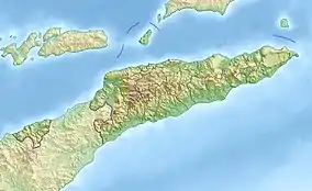
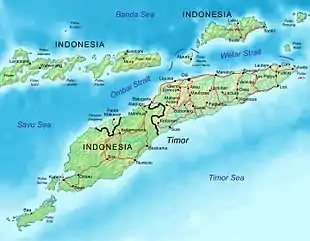
The strait is relatively narrow and deep, and has complex bathymetry.[3] It separates the Alor Archipelago from the islands of Wetar, Atauro, and Timor in the Lesser Sunda Islands.[4] It also straddles the boundary between the Banda Sea (in its north east) and the Savu Sea (in its south west).[3][5][6]
The Alor Archipelago, and the western part of Timor except the coastal exclave of Oecusse, which is on the north coast of western Timor, are part of the province of East Nusa Tenggara, Indonesia. Wetar is part of the Maluku Province of Indonesia. Atauro, Oecusse, and the eastern part of Timor comprise the nation of East Timor.[4]
The southern limit of the Banda Sea runs along the southern edge of the strait from the eastern extremity of Timor along its north coast as far south west as longitude 125° East. From that point, the Banda Sea's western limit heads north to Alor Island, where it starts a further run, east, along Alor's south coast, around its east point, and beyond.[5]
Meanwhile, the Ombai Strait continues to run from longitude 125° East in a south westerly direction, now within the limits of the Savu Sea. It extends, as part of that sea, at least as far south west as Batek Island, at the north western tip of Oecusse.[5][6]
As such, the strait is one of two deep water passages in the Indonesian archipelago that link the waters of the Pacific and Indian Oceans. The archipelago is the only interocean connection on earth at low latitudes, and the exchange of water between the two oceans is known as the Indonesian Throughflow (ITF).[3]
The ITF flows in a generally north east to south west direction. Its main pathway runs from the Pacific Ocean into the Banda Sea via the Celebes Sea, Makassar Strait and the Java and Flores Seas. Some of the ITF then passes directly into Ombai Strait, and some of it flows there indirectly, around Wetar Island's eastern end, and then via the Wetar Strait.[7]
From the Ombai Strait's south western, Savu Sea, end, the strait heads in a generally north eastern direction, while gradually narrowing.[3][4] At its narrowest point between the Alor Archipelago and Timor, it is 27 km (17 mi) wide, and its navigable waters are 26 km (16 mi) across.[8]
Beyond the end of the channel at the strait's north eastern extremity, between the islands of Alor and Atauro, is the Flores Sea to the north west and north, and the Banda Sea to the north east. That channel is 35 km (22 mi) wide at its narrowest point, where the navigable waters are 34 km (21 mi) across.[4][8] To the east of the strait, and linking with it south of Atauro, is the Wetar Strait. To the east of the latter strait are the south eastern reaches of the Banda Sea, and the southernmost of the Maluku Islands.[4][8][9]
Ecology
Flora
.jpg.webp)
In parts of the Ombai Strait, and especially close to the coast of Alor Island, elevated phytoplankton blooms or concentrations (and therefore availability of food for other species) have been observed, particularly during the dry south-east monsoon.[2][3] The physical structure of the strait makes it likely that such concentrations are driven by fronts and vertical flows caused by some combination of tidal currents or topographic effects.[3]
A study published in 2002 noted persistent flow-induced upwelling and frontal features in the strait, together with subjective evidence of extremely strong tides. The study concluded that the upwelling and frontal features coincided with large phytoplankton blooms and significantly affected the concentration and distribution of chlorophyll in the Savu Sea. According to the study report, it is likely that the mean flow associated with the ITF also plays a role in causing the blooms.[3]
Along the northern littoral of East Timor, including the strait, the shallow coastal waters are dominated by a seagrass bed about 2,200 ha (5,400 acres) in total area.[10]: 2-29–2-30 Seagrass beds protect coral reefs from sedimentation and are feeding grounds for dugong (Dugong dugon), an endangered species.[11]: 82 Seven genera of seagrass are known to exist off East Timor's coastline as a whole.[10]: 2-29
East Timor's coastal waters have also traditionally hosted mangrove forests. Together with seagrasses and coral reefs, they are the primary breeding grounds for many species of fish and shellfish. However, the country's mangrove cover has very substantially declined since 1940, and in the Ombai Strait is now confined to the coastline and hinterland between Tibar and the Bay of Dili.[11]: xvi, xvii, 3–5, 81, 82 [12]: 3
A survey of Tibar Bay carried out in 2016 found three mangrove species, namely Sonneratia alba, which was the dominant species, Avicennia marina and Rhizophora stylosa.[13]: 2, 8 The report of another survey, carried out in 2017, stated that the dominant species in the area was Sonneratia albia, and that there were some clusters of Rhizophora apiculata, Ceriops tagal, and Lumnitzera.[12]: 14
The 2016 survey report estimated the total area of mangrove in the bay to be 14 ha (35 acres);[13]: 2, 8 the 2017 survey report's estimate was 22 ha (54 acres). According to the latter report, tree density was relatively low, at around 100–400 trees per hectare, and the mangrove cluster was heavily degraded, due to direct and indirect human activities. The former activities included fish pond and salt pan development, mangrove cutting, and cattle grazing. The latter activities were sea level rise, and siltation due to erosion in the hills on the landward side of the mangroves.[12]: 7, 13–14, 22–23
Fauna
The Ombai-Wetar corridor is heavily used by whales, dolphins, whale sharks (Rhincodon typus) and manta rays. The two straits combine to form a major migratory route for them between the Pacific and Indian Oceans.[14] The Ombai Strait has been identified as a critical habitat for sperm whales (Physeter macrocephalus), blue whales (Balaenoptera musculus), giant oceanic manta rays (Manta birostris) and sea turtles (Cheloniidae), amongst other endangered, threatened and protected species.[15] East Timor, on the south side of the two straits, is a recognized ‘global hotspot’ for whales and dolphins.[16]
The report of a 2013 survey of Tibar Bay, on Ombai Strait's southern shore not far west of Dili, East Timor, noted that a local dive tourism operator had made frequent sightings of dugong along the coast immediately east of the bay, and that there were also anecdotal reports of saltwater crocodiles in the bay.[14]
.jpg.webp)
A short distance further east, at Tasitolu, dugongs are often observed, although as of 2019 detailed information regarding their habitat location, size, and characteristics in the area was not available.[10]: 2-29 The other sea life at Tasitolu includes cephalopods, crustaceans, frogfish, harlequin ghost pipefish, small octopuses, rhinopias, sea horses, and soft coral crabs.[17]
Ombai Strait is also part of the Coral Triangle, which is recognised as a global centre of marine biodiversity.[18] The coastal zones of East Timor have important areas of coral reef ecosystems, such as the ones at Tasitolu and in the Bay of Dili. At Tasitolu, the reefs west of Dili Rock are live, healthy and diverse, but those to the east of the rock have lower coverage and more reef rubble. At the Port of Dili inside the Bay of Dili, there are at least four different species of coral.[10]: 2-29–2-30
The Dili area, on the southern edge of the strait, is a recognised nesting ground for sea turtles, of three different species: hawksbill sea turtle (Eretmochelys imbricata; Critically Endangered (CR), according to the International Union for Conservation of Nature (IUCN) Red List), olive ridley sea turtle (Lepidochelys olivacea; Vulnerable (VU)), and green sea turtle (Chelonia mydas; Endangered (EN)). On both the Tasi Tolu Beach and the Beto Tasi Beach near Dili's international airport, there is regular hatching of sea turtles.[10]: 2-29 However, in most parts of East Timor sea turtles are overharvested for their eggs, skin, meat and carapace for handicraft making.[11]: xviii
The northern edge of the strait abuts two Important Bird Areas (IBAs), Gunung Muna (on Alor Island, Indonesia),[19] and Atauro Island (East Timor).[20] The southern edge of the strait is also the northern shore of four East Timorese IBAs. From west to east, they are Be Malae (just to the west of the Loes River), Maubara (a short distance east of the village of Maubara), Tasitolu (just to the west of Dili), and Areia Branca no Dolok Oan (on the eastern side of the Bay of Dili).[21]
Navigation
Commercial
.jpg.webp)
Under the United Nations Convention on the Law of the Sea, a commercial vessel or aircraft has freedom of navigation or overflight solely for the purpose of continuous and expeditious transit of a strait between one part of the high seas or exclusive economic zone and another.[22] That transit passage principle applies to the Ombai Strait and Wetar Strait, as they combine to link two oceans.[23][24]
The Ombai-Wetar route is longer in distance than its Strait of Malacca-Singapore Strait counterpart. The former route is therefore not really a preferred alternative path for west to east commercial traffic.[23] However, it is sometimes used, and is considered the safest route, for the largest oil tankers transiting between the Persian Gulf and Japan, and is also used by vessels transiting between Australia and the Java Sea or East Asia.[24]
The two straits are always critical for East Timor, both in relation to its own international trade and as routes for internal transport.[24] In the Ombai Strait, internal East Timorese ferry services operate regularly between Dili and both Atauro and Oecusse.[25] If there were any disruption in the flow of commercial shipping on the Malacca-Singapore route, the Ombai-Wetar route would also have a crucial role to play in global trade, especially for the Asia-Pacific region.[24]
Military
The ships and aircraft of all nations, including warships, auxiliaries, and military aircraft, enjoy the right of unimpeded transit passage through straits such as the Ombai-Wetar route and their approaches. Submarines are free to transit the route submerged, as that is their normal mode of operation.[26]
The channels of the Ombai-Wetar route are extremely deep.[23] East Timor has refused advances by China seeking off-shore oil rights and permission to set up radar arrays ostensibly to counter illegal fishing.[24]
The two straits therefore provide a route for undetected access by nuclear-powered submarines between the two oceans they connect.[23][24] In particular, they are an alternative deep water route for submerged U.S. submarines moving between Guam and stations in the Indian Ocean via the Molucca Passage, Indonesia, which separates Sulawesi from Halmahera.[8] Although the Ombai-Wetar route is a less direct link between Guam and the Indian Ocean than the Lombok-Makassar route, it is useful because it has limited traffic and very little surveillance, with the consequence that passing submarines are less likely to be tracked.[8]
By the mid-1970s, the Ombai-Wetar route had been identified as one of five international straits essential for passage by U.S. ballistic missile submarines, the others being Gibraltar, Malacca-Singapore, Lombok and Sunda.[24][27] In 1977, a paper published by the International Institute for Strategic Studies, based in London, ranked the Ombai-Wetar route as the second-most-important strait in the world to U.S. defense interests, after the Strait of Gibraltar.[28] The two straits are now also considered by China to be strategically significant.[24]
Economy
Annual migrations of whales and dolphins along the Ombai-Wetar route provide some of the best and most accessible whale watching in the world. In East Timor, the whale watching industry has been growing rapidly since the 2010s. Cetaceans migrating along the route are often very close to shore; networks of local residents record their movements and behaviour, and then report it in 'real time' to researchers and Dili-based whale watching tour operators.[16]
References
- Gazeteer of Indonesia. Vol. II (N–Z) (3rd ed.). Washington, DC: Defense Mapping Agency. September 1982. p. 880.
- Hunnam, Kimberley; Carlos, Imelda; Hammer, Michael P.; Dos Reis Lopes, Joctan; Mills, David J.; Stacey, Natasha (2021). "Untangling Tales of Tropical Sardines: Local Knowledge From Fisheries in Timor-Leste". Frontiers in Marine Science. 8. doi:10.3389/fmars.2021.673173/full. ISSN 2296-7745. Retrieved 15 April 2022.
- Moore, Thomas; Marra, John (27 February 2002). "Satellite observations of bloom events in the Strait of Ombai: Relationships to monsoons and ENSO". Geochemistry Geophysics Geosystems. 3 (2): 2. doi:10.1029/2001GC000174. ISSN 1525-2027. Retrieved 26 April 2022.
- Molcard, R.; Fieux, M.; Syamsudin, F. (2001). "The throughflow within Ombai Strait". Deep Sea Research Part I: Oceanographic Research Papers. 48 (5): 1237. doi:10.1016/S0967-0637(00)00084-4.
- "Limits of Oceans and Seas, 3rd edition" (PDF). International Hydrographic Organization. 1953. pp. 27, 30. Archived from the original (PDF) on 8 October 2011. Retrieved 28 December 2020.
- Arsana, I. Made Andi; Rizos, C.; Schofield, Clive H. (2006). "The application of GIS in maritime boundary delimitation: a case study on the Indonesia-East Timor maritime boundary delimitation". In Abdul-Rahman, A.; Zlatanova, S.; Coors, V. (eds.). Innovations in 3D Geo Information Systems. Lecture Notes in Geoinformation and Cartography series. Berlin: Springer. pp. 695–719. doi:10.1007/978-3-540-36998-1_53. Retrieved 19 April 2022.
- Susanto, R. Dwi; Song, Y. Tony (April 2015). "Indonesian throughflow proxy from satellite altimeters and gravimeters". Journal of Geophysical Research: Oceans. 120 (4): 2844–2855. doi:10.1002/2014JC010382. ISSN 2169-9275. Retrieved 27 April 2022.
- Leifer, Michael (1978). Malacca, Singapore, and Indonesia. International Straits of the World, Volume 2. Alphen aan den Rijn: Sijthoff & Noordhoff. pp. 83–85. ISBN 9028607781.
- Sailing Directions for Java: Lesser Sundas; South, Southeast, and East Coasts of Borneo; and Celebes. Publication - Defense Mapping Agency, Hydrographic Center, no. 72 (revised 5th (1962) ed.). Washington, DC: U.S. Dept. of Defense, Defense Mapping Agency, Hydrographic Center. 1976. p. 267. ISBN 1038099951.
- Nippon Koei Co (November 2019). Democratic Republic of Timor-Leste: Preliminary Assessment for Dili Airport Runway Upgrading Project (Financed by the Technical Assistance Special Fund) (PDF) (Report). Asian Development Bank (ADB). Project Number:52320-001. Retrieved 9 April 2022.
- The National Biodiversity Strategy and Action Plan of Timor-Leste (2011 – 2020) (PDF) (Report) (rev. ed.). Democratic Republic of Timor-Leste. 2015. Retrieved 16 April 2022.
- Ilman, Muhammed (2017). Assessment Report of the Biophysical, Ecological and Socio-Economic Conditions of Mangroves Ecosystem of Timor Leste (Report). UNDP/MAF. Retrieved 6 March 2022.
- Trainor, Colin R. (December 2016). Vegetation and Fauna of the proposed Tibar Bay Port (Report). Trainor Ecological Solutions. Retrieved 6 March 2022.
- Tibar Bay Port: Summary of Environment and Social Scoping Study (PDF) (Report). Government of Timor-Leste. November 2013. p. 12. Retrieved 4 March 2022.
- Kahn, Benjamin (2015). "Towards conservation of the Ombai Strait in the Indo-Pacific migration corridor". In Vasilijevic, Maja; Zunckel, Kevan; McKinney, Matthew; Erg, Boris; Schoon, Michael L.; Michel, Tatjana Rosen; Groves, Craig; Phillips, Adrian (eds.). Transboundary Conservation: A systematic and integrated approach. Gland, Switzerland: International Union for Conservation of Nature. ISBN 9782831717227.
- Edyvane, Karen (9 December 2021). "From fishing to 'whale spotting' in Subaun: Citizen science, local knowledge and partnerships combine to make unique whale watching in Timor-Leste". Tourism Timor-Leste. Retrieved 11 April 2022.
- "Tasi Tolu". Wanna Dive. Retrieved 21 July 2012.
- Allen, G. R. 2007 Conservation hotspots of biodiversity and endemism for Indo-Pacific coral reef fishes. Aquatic Conserv: Mar. Freshw. Ecosyst. doi:10.1002/aqc.880
- BirdLife International (2022). "Gunung Muna". BirdLife International. Retrieved 21 April 2022.
- BirdLife International (2022). "Atauro Island". BirdLife International. Retrieved 21 April 2022.
- BirdLife International (2022). "Important Bird Areas – Timor-Leste". BirdLife International. Retrieved 15 April 2022.
- "United Nations Convention on the Law of the Sea", Part III, Article 38.
{{cite web}}: CS1 maint: postscript (link) - Mohd Rusli, Mohd Hazmi bin (10 February 2012). "Maritime Highways of Southeast Asia: Alternative Straits?" (PDF). RSIS Commentaries. S. Rajaratnam School of International Studies (024/2012): 2. Retrieved 30 March 2022.
- Borges, Duarte (2021). "A maritime strategy for Timor-Leste" (PDF). Sea Power Soundings. Royal Australian Navy (20). Retrieved 2 April 2022.
- "Transport: By Boat". Tourism Timor-Leste. 8 August 2016. Retrieved 2 April 2022.
- Van Dyke, Jon M. (2 October 2008). "Transit Passage Through International Straits" (PDF). The Future of Ocean Regime-Building. University of Hawaii. pp. 178, 179, 186–187, 194–197. doi:10.1163/ej.9789004172678.i-786.50. ISBN 9789004172678. Retrieved 6 July 2019.
- Osgood, Robert E.; Hollick, Ann L.; Pearson, Charles S.; Orr, James C. (1976). Toward A National Ocean Policy, 1976 and Beyond. Washington, DC: Ocean Policy Project, Johns Hopkins University. p. 4.
- Jolliffe, Jill (29 April 1986). "The war Indonesia denies. Documents suggest fighting in East Timor continues". The Christian Science Monitor. Retrieved 2 April 2022.
External links
![]() Media related to Ombai Strait at Wikimedia Commons
Media related to Ombai Strait at Wikimedia Commons
Indonesian seas | |
|---|---|
| Ocean | |
| Sea | |
| Strait |
|
| Gulf | |