North Morowali Regency
North Morowali Regency is a regency in the province of Central Sulawesi, Indonesia. The regency was established on 12 April 2013, partitioned from the northwestern districts of Morowali Regency.[2] It covers an area of 10,004.28 km2 and the component districts had a combined population of 104,094 at the 2010 Census.[3] The new regency had 120,789 inhabitants at the 2020 Census - comprising 62,965 male and 57,824 female.[4] The principal town lies at Kolonodale.
North Morowali Regency
Kabupaten Morowali Utara | |
|---|---|
 Coat of arms | |
| Motto(s): Tepo Asa Aroa | |
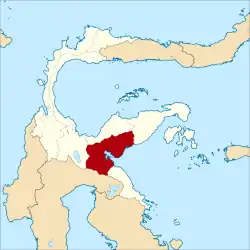 Location within Central Sulawesi | |
| Coordinates: 1.9870°S 121.3390°E | |
| Country | Indonesia |
| Region | Sulawesi |
| Province | Central Sulawesi |
| Capital | Kolonodale |
| Government | |
| • Regent | Aptripel Tumimomor |
| • Vice Regent | Moh. Asrar Abd. Samad |
| Area | |
| • Total | 3,862.67 sq mi (10,004.28 km2) |
| Population (2020 Census)[1] | |
| • Total | 120,789 |
| • Density | 31/sq mi (12/km2) |
| Time zone | UTC+8 (ICST) |
| Area code | (+62) 465 |
| Website | morowaliutarakab |
Administrative Districts
The North Morowali Regency was divided (following its separation from Morowali Regency in 2013) into seven districts (kecamatan), but three further districts (Lembo Raya, Petasia Timur and Petasia Barat) were created. These are all tabulated below with their areas and their populations at the 2010 Census[5] and the 2020 Census.[6] The table also includes the location of the district headquarters, the numbers of administrative villages (rural desa and urban kelurahan) in each district, and its postal codes.
| District Name | Area in km2 | Population Census 2010 | Population Census 2020 | Admin centre | Number of villages | Post codes |
|---|---|---|---|---|---|---|
| Mori Atas | 1,508.81 | 10,418 | 12,510 | Tomata | 14 | 94965 |
| Lembo | 675.23 | 20,300 | 14,396 | Beteleme | 10 | 94966 |
| Lembo Raya | 657.61 | (a) | 8,241 | Petumbea | 10 | 94967 |
| Petasia Timur (East Petasia) | 509.77 | (b) | 16,428 | Bungintimbe | 12 | 94963 |
| Petasia (c) | 646.34 | 33,705 | 17,997 | Kolonodale | 10 | 94971 |
| Petasia Barat (West Petasia) | 480.30 | (b) | 7,711 | Tiu | 10 | 94970 |
| Mori Utara (North Mori) | 1,048.93 | 6,819 | 8,023 | Mayumba | 8 | 94964 |
| Soyojaya | 605.51 | 7,884 | 8,821 | Lembah Sumara | 10 | 94969 |
| Bungku Utara (d) (North Bungku) | 2,406.79 | 14,699 | 15,853 | Beturube | 23 | 94972 |
| Mamosalato | 1,464.99 | 10,269 | 10,809 | Tanasumpu | 14 | 94968 |
| Totals | 10,004.28 | 104,094 | 120,789 | 125 |
Notes: (a) the 2010 population of Lembo Raya District is included in the figure for Lembo District from which it was cut out in 2013. (b) the 2010 populations of Petasia Timur District and Petasia Barat District are included in the figure for Petasia District from which they were cut out in 2013. (c) including 44 offshore islands. (d) including 15 offshore islands.
References
- Badan Pusat Statistik, Jakarta, 2021.
- "Mendagri resmikan 3 kabupaten baru". Sindo News. Archived from the original on 25 March 2014. Retrieved 25 March 2014.
- Biro Pusat Statistik, Jakarta, 2011.
- Badan Pusat Statistik, Jakarta, 2021.
- Biro Pusat Statistik, Jakarta, 2011.
- Badan Pusat Statistik, Jakarta, 2021.
External links
Regencies and cities of Central Sulawesi | ||
|---|---|---|
Capital: Palu | ||
| Regencies | ||
| Cities | ||